Local hunter (Khanty people) with hand-made hunting bow using for small game killing. Yamal Penisula, Yamalo-Nenets Autonomous Okrug, July 11, 2012. Photo credit © by Konstantin Klokov.
Wilderness as Nature Conservation Indicator for Regional Policy Making in Russia
International Perspectives
August 2021 | Volume 27, Number 2
PEER REVIEWED
ABSTRACT
Wilderness has etymologically multiple meanings that results in a wide variety of corresponding approaches for study and interpretations. In this research, pieces of wild nature were considered as spatial units of terrestrial wilderness. Areas of wilderness were evaluated using GIS-based technologies within 45 Russian regions, where territories of wild nature still exist. Three wilderness-related traits were estimated for each federal subject: proportion of wilderness areas, proportion of protected areas, and proportion of protected wilderness. Then structural relationships between the subjects and variability among them were analyzed using standard and recently developed tools of community ecology (metrics of functional trait dispersion and singularity) to establish groups of closely related regions and evaluate specificity (singularity) of each region. Such classification of wilderness status in different regions is a highly important issue for policy makers to clearly determine objectives of nature protection, to shape proper feasible ways of reaching those objectives, and to efficiently manage sites of biodiversity conservation. New tools of wilderness data analysis used in this study can facilitate development of problem-oriented solutions of nature preservation. Specially protected territories are a traditional and highly effective form of nature and environment preservation in Russia. However, the internationally accepted ‘wilderness’ category should also be put into official use in Russia to form a legislative basis for preserving large territories in Siberia, the Far East and Arctic, and still existing patches of wild nature in other regions, mainly in the European part of Russia.
The concept of wilderness is an environmental philosophy that emerged and has been primarily developed in North America. Moreover, many central topics and approaches of wilderness clearly reflect a North American perspective and environmental issues (Drenthen and Keulartz 2014). An intensive constantly growing anthropogenic pressure on wilderness persisted since the second half of the 20th century all around the world. Huge territories of wilderness have been destroyed and continuously replaced by industrial, urban, and rural areas. These processes of land transformation have also been accompanied by numerous conflicts between economic and social issues, industrial development and need in biodiversity conservation and maintenance of ecosystem services with a special emphasis on the role of wilderness (Sanderson et al. 2002). Russian landscapes provide significant impact on worldwide biodiversity of boreal and arctic ecosystems, support services of those ecosystems, and thus, are critically important wilderness areas on the globe (Bukvareva et al. 2019; Bocharnikov and Huettmann 2019). Unfortunately, recent analyses of the structure of environmental landscapes in Russian regions revealed that since the industrial development in the former USSR, considerable contrasts still remain between developed and wilderness areas. In particular, deployment of industrial complexes and settlements is frequently planned without a comprehensive analysis and deep understanding of demands of nature preservation that results in conflict between economic development and protection of natural resources (Bityukova 2019).
Our current research is aimed at the presentation of integral approaches and metrics to assess anthropogenic effects on wilderness in different regions of Russia. We employ recently developed techniques to study functional variability of ecological communities (Scheiner et al. 2017; Kosman et al. 2019) with the idea to evaluate the extent of wilderness in Russia at a regional scale and to determine areas with similar features of nature preservation. The suggested approaches are based on a proper assessment of dissimilarity between different regions and evenness of distribution of those dissimilarities. Mapping and differentiation of Russian regions are especially important due to the huge territory of Russia and high heterogeneity of natural conditions, ecological systems, distribution of human resources and activities, and social and cultural attributes (Bocharnikov 2017). In this study, landscapes are considered as geosystems (Sochava 1978), with a hierarchical physical-geographic taxonomic order, that need a system-scale research methodology for their analyses (Mateo et al. 2019). We intend to suggest basic tools that can facilitate making decisions of nature conservation that account for a wide range of economic, human, social, cultural, environmental and wilderness factors, and avoid land use conflicts (Bocharnikov 2016).
Methods
The Russian Federation consists of republics, krais, oblasts, cities of federal importance, an autonomous oblast and autonomous okrugs, all of which are equal subjects of the Russian Federation. There are eighty-five federal subjects in Russia, which are grouped into eight federal districts (Figure 1). Each subject of the Russian Federation has its own government and budget, determines regional policy and responsible for industrial development and environment and nature protection in the corresponding region (status of the Russian subjects is rather similar to that of separate states in the USA). Since one of the central objectives of our study is to demonstrate a way of providing information and practical recommendations to persons in charge for both economy and wilderness protection in generally independent subjects, size of the corresponding regional territories does not play any role in making decision how to reach a balance between economic development and nature conservation in a given region.
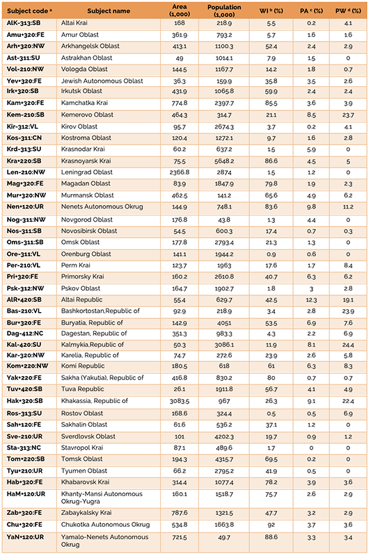
Table 1 – Attributes and basic parameters of federal subjects of Russia
a – subject code consists of four parts in the following order: (1) the first three letters designate a subject name; (2) signs ‘+’ or ‘-’ indicate ‘positive’ or ‘negative’ singularity, respectively; (3) three digits label subject typology* (see below); (4) the last two letters designate a name of federal district** the subject belongs to (see below);
b – wilderness index;
c – proportion of officially protected areas of federal importance;
d – proportion of protected wilderness.
* Typology of federal subjects according to the Social Atlas of Russian regions: 1.1. Federal City; 1.2.0. Oil and gas producing regions; 2.1.0. Developed zone with relatively high income; 2.2.0. Weakly developed zone with relatively high income; 3.1.1. Moderately developed urban industrial region; 3.1.2. Moderately depressed industrial region; 3.1.3. Rural regions. 3.2.0. Weakly developed zone; 4.1.1. Depressed area. 4.1.2. Underdeveloped republics of the South; 4.2.0. Outsiders, poorly developed zone.
** Names of eight federal districts are encoded as follows: Far Eastern (FE), Volga (VL), Siberian (SB), North Caucasian (NC), Northwestern (NW), Central (CN), Ural (UR), Southern (SU).
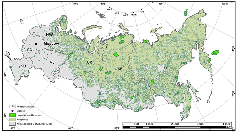
Figure 1 – Anthropogenic landscape and large federal protected areas within federal districts of Russian territory. Distribution of terrestrial wilderness, protected, urban and rural areas.
Original data characterization.
Only terrestrial wilderness was considered in the current research initiated in 2015. The research has been focused on a monitoring of wilderness disturbance in Russia due to anthropogenic activity. Forty-five different administrative units (federal subjects) in Russia with still existing patches of wilderness were analyzed (for details see Table 1). Using Geographic Information Systems (GIS) data, we were able to get rather precise quantitative estimates of all off-road and uninhabited (or nearly uninhabited) and anthropogenically disturbed areas with a resolution of 50 thousand hectares (500 square km). Due to a huge territory of Russia, much larger resolution of wilderness (Figure 1) was used comparing with the commonly accepted approaches for smaller countries, where the minimum area of wilderness is assumed to be 5000 acres or 20.2 square km (Carver and Fitz 2016).
The GIS data allowed calculation of a wilderness index (Bocharnikov and Egidarev 2015; Bocharnikov and Huetmann 2019), which is further designated as WI. The WI metric expresses a wilderness proportion of total area and was selected as the leading indicator of wilderness in the current study. In parallel, we also determined a metric of anthropogenic disturbance (AD) as a proportion of total area ‘occupied’ by a human. Since WI+AD=1, an accurate evaluation of territories harmed by anthropogenic activity (AD index) allows for assessment of wilderness. Thus, there is a need in clear definition and proper measuring of all human activities that are assumed to destroy wilderness. The following are human-made objects we accounted for calculating AD index (i.e. objects that reduce areas of wilderness): populated areas (city, town, village, settlement etc.), industrial zones and infrastructure in their vicinity, agricultural areas, detached units (factory, farm, railway station, port etc.) transportation routes (land roads, railway, waterway, pipeline, power transmission lines etc.), lands adjacent to a water basin (ocean, sea, navigable lake, river etc.).
Wilderness borders were mainly determined using topographic maps Digital Chart of the World Data (DCW) with 1:1000000 scale that were updated from time to time during the period of 2002 – 2015 by Russian company DATA+. The obtained information was much more accurate than that provided by a global map of roadless areas (Ibisch et al. 2016).
Areas covered by the objects and/or their buffers are shown in Table 2; an extent of wilderness reduction by every object depends on its type. The index of anthropogenic disturbance is determined as follows:
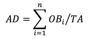
where n is a total number of objects specified in Table 2 in a given region, OBi is an area affected by one of those objects (Table 2), and TA is a total area of that region. Then the wilderness index equals
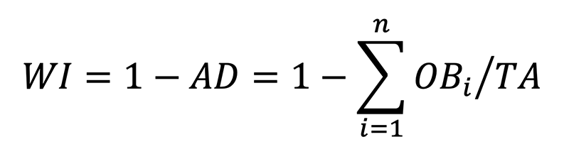
This transparent descriptive parameter provides basic assessments of wilderness in different regions. Much more complicated analysis was performed with two additional parameters along with the index of wilderness.
The second parameter is proportion of officially protected areas (PA) of federal importance in a given administrative unit. The only protected areas in Russia (“Specially Protected Natural Areas”) are territories of nature preservation according to the corresponding 1995 law of the Russian Federation. Under the law, the specially protected natural territories (biosphere reserves, national parks etc.) represent the areas of land, water and aerial space over them containing the natural complexes and facilities of a special conservation, scientific, cultural, esthetic, recreational and health-improving significance. The basic element of protection of this type of territories is the limitation or the absolute prohibition of economic activities on them.
The third parameter is proportion of protected wilderness (PW; includes zapovedniks and national parks), which is calculated as ratio of wilderness area within protected territories of federal importance (see previous paragraph) and total area of wilderness in a given administrative unit.
Data analysis
Original data included the following three characteristics (n=3) of every subject among 45 considered (k=45): proportions of wilderness (X_1=WI), protected areas (X_2=PA), and protected wilderness (X_3=PW) in a given subject (Table 1). To equally weigh effects of each of the traits X_1, X_2 and X_3, the data were standardized in order to range in [0,1] interval using transformation X_i (→(X_i-min〖X_i 〗 ))⁄((max〖X_i 〗-min〖X_i 〗 ) ), so that min〖X_i 〗 and max〖X_i 〗 (i=1,2,3) were transformed to 0 and 1, respectively.
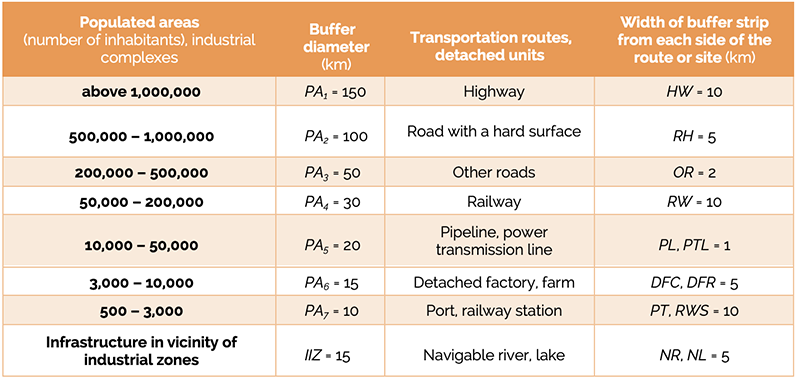
Table 2 – Objects with negative anthropogenic effect on wilderness and their buffer zones (parameters of AD- and WI-indices of anthropogenic disturbance and wilderness, respectively)
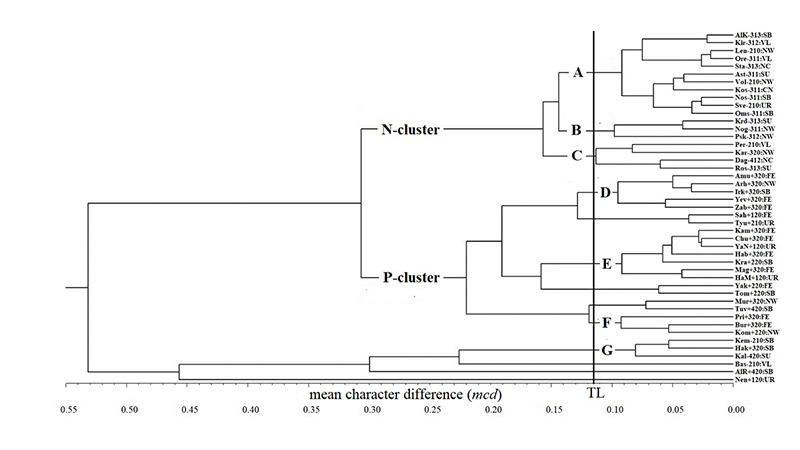
Figure 2– UPGMA dendrogram of relationships between 45 federal subjects of Russia (subjects are encoded as in Table 1). All tips of N- and P-cluster branches are of ‘negative’ and ‘positive’ singularity. TL is a threshold level that results in division of all subjects into 13 groups (including singletons) of closely related ones according to the effective number of different subjects (13.26). Seven such groups (A – G), each consisting of at least 3 subjects (tips of the corresponding branches), are shown.
Standard and recently developed tools for study functional variation and biodiversity preservation in community ecology (Scheiner et al. 2017; Kosman et al. 2019) were applied to analysis of wilderness variability in Russia. Three types of data analysis were performed in order (a) to separate all subjects into relatively homogeneous groups based on the UPGMA dendrogram for clustering; (b) to estimate an effective number of different subjects (Scheiner et al. 2017) that is usually much smaller than the actual number of different subjects because some subjects are rather similar and thus can be considered nearly indistinguishable; and (c) to evaluate uniqueness of each subject among all subjects by determining its singularity (Kosman et al. 2019). All analyses were based on pairwise distances between subjects S_i and S_j (i,j=1,2,…,45) calculated with the mean character difference (Manhattan distance normalized by the number of traits):
![]()
with n=3 in our case. Values of the mcd distance range between 0 and 1.
A dendrogram of relationships between the subjects were constructed using unweighted pair group method with arithmetic mean (UPGMA dendrogram) with regard to the mcd distance (Figure 2). It generated groups of similar subjects and reflected the structure present in the matrix of mcd distances between the subjects. The UPGMA dendrogram was derived using the SAHN program of the NTSYSpc package, version 2.2 (Exeter Software, Setauket, NY).
Effective number of different subjects among the 45 original ones was estimated with the metric of functional trait dispersion, derived from Scheiner et al.’s (2017) equations 5 and 6 which measured functional trait dispersion determined by the dispersion of species in trait space and measures the effective number of functionally distinct species If k original subjects are compared, then the effective number ranges from 1 to k when all subjects are ‘identical’ and absolutely different, respectively. Thus, this indicator expresses an extent of variability among the subjects.
Singularity of every subject was evaluated relative to all other subjects (k-1=44) according to Kosman et al. (2019). This estimate is aimed at determining an extent of uniqueness of each subject in the given set. However, two subjects with very distinct trait profiles can be equally distant from all other subjects, and thus, equally unique, like two ends of an interval from its center. Therefore, two types of singularity, ‘positive’ and ‘negative’, can be defined with regard to a selected criterion (e.g. an estimate of a leading parameter). The proportion of wilderness in total area (X_1=WI, wilderness index) was chosen as the leading indicator due to its foremost significance comparing with other two features. We assumed that a level of wilderness less than 25% in a given subject is insufficient, and immediate intervention of local policy makers is needed to increase financing and to improve management of nature conservation in the corresponding region. Therefore, a threshold level of WI=0.25 was selected, so that the singularity of a given subject was considered ‘positive’ or ‘negative’, if the singularity of that subject was above or below the threshold level, respectively. The performed analyses of 45 federal subjects revealed huge differences among them. Effective number of different subjects was 13 among the 45 original ones. This means that a separation of all 45 federal subjects into 13 groups of closely related ones (including singletons) could be well justified. Such division into clusters was obtained by grouping subjects at the threshold level of mcd distance around 0.11 – 0.12 at the UPGMA dendrogram (Figure 2).
Results
The analyses revealed large differences between the 45 federal subjects of Russia. The wilderness index (WI, proportion of wilderness) ranged from 0.5% in Rostov Oblast to 92% in Chukotka Autonomous Okrug; protected areas did not exist in Stavropol Krai, whereas the largest proportion of protected areas (PA) was in Altai Republic (12.3%); maximum proportion of protected wilderness (PW) was in Republic of Kalmykia (24.4%), but wilderness was not protected in 10 federal subjects from 7 federal districts (Table 1).
Clear separation of the set of 45 federal subjects into several groups with strong hierarchical structure results from the UPGMA dendrogram (Figure 2). Each group consists of subjects with closely related trait profiles (similar values of most parameters). There are two large clusters that consist of subjects with proportion of wilderness in total area either below or above 25% (N-cluster with WI<0.25, and P-cluster with WI≥0.25, respectively). There are also six outliers in the bottom of the dendrogram. At the lower hierarchical level, the two major clusters of subjects are subdivided into smaller groups, each of which can be characterized by a specific range of either of the three features of the group constituents. Groups consisting of three federal subjects at least and their features are show in Table 3.
For example, group A in N-cluster is characterized by WI values from 0.9 to 21.3, PA – from 0 to 1.8, and PW – from 0 to 4.1, whereas group C has those parameters in ranges 0.5 – 23.9, 0.5 – 2.6, and 5.8 – 8.4, respectively. Thus, these two groups of federal subjects are mainly distinguished by the proportion of protected wilderness PW, [0,4.1] versus [5.8,8.4]. For P-cluster, group D differs considerably from group E by the proportion of wilderness with WI values from 5.7 to 59.9 and from 75.7 to 92.0, respectively, while all three parameters WI, PA and PW distinguish subjects from groups E and F (Table 3). The highest values of proportion of protected wilderness (PW) strongly distinguished federal subjects in group G (as well as all six outliers) from all other subjects (Table 3).
Importantly, the grouping of federal subjects based on the selected criteria does not necessarily mean that those subjects have similar geographic, climatic or any other environmental conditions. Moreover, their geography and climate could be very different, and they could be far away from each other. For example, group C includes mountainous Republic of Dagestan in the south-east of the European part of Russia and plain Republic of Karelia with much cooler climate in the north-west of the European part; distance between these subjects is about 2,800 km. Two other federal subjects from this cluster are Rostov Oblast from the steppe zone in the south of the European part of Russia and Perm Krai from the boreal forest zone in the northern part of Ural Mountains (north-east of the European part).
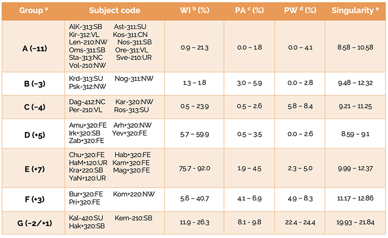
Table 3 – Groups of federal subjects and ranges of the subject parameters within them.
a – groups were determined according to the UPGMA dendrogram (Fig. 2); number of subjects of ‘positive’ (+) or ‘negative’ (−) singularity within a group are shown in parentheses;
b – range of wilderness index for subjects within a group;
c – range of proportion of officially protected areas of federal importance for subjects within a group;
d – range of proportion of protected wilderness for subjects within a group;
e – range of absolute value of singularity for subjects within a group.
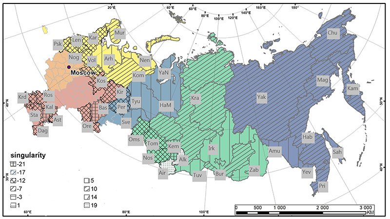
Figure 3– Map of singularity of federal subjects of Russia.

Figure 4– Federal subjects of Russia with negative and positive singularity
The extent of specificity of every subject estimated with the singularity measure is shown in Figure 3. Separate clusters of closely related subjects were characterized by a narrow range of either positive or negative singularity values. The most positively singular federal subjects were Altai Republic (23.7), Republic of Khakassia (21.3), and Nenets Autonomous Okrug (19.9), whereas the worst situation with wilderness was indicated by foremost negative singularity in Republic of Kalmykia (-21.8), Kemerovo Oblast (-21.4), and Republic of Bashkortostan (-19). All these extremely singular subjects belong to the branch of outliers in the bottom of the dendrogram (Figure 2).
Discussion
Protection and maintenance of all natural resources is one of the central issues considered by policy makers all around the world. One of such resources is ‘wilderness’ that denotes specificity and format of territorial protection of landscapes, ecosystems, and certain areas identified in accordance with national criteria in various regions of the world. Despite ‘wilderness’ as an international category, Russian environmental standards are based on different categories such as ‘biosphere reserves’, ‘national parks’ etc. that have strict protection regimes. We considered elements of wilderness in Russian regions, including within protected areas, in order to partially adjust the Russian data to the international standards that can facilitate comparison of various aspects of environment preservation and wildlife conservation in different countries (Figures 5, 6).
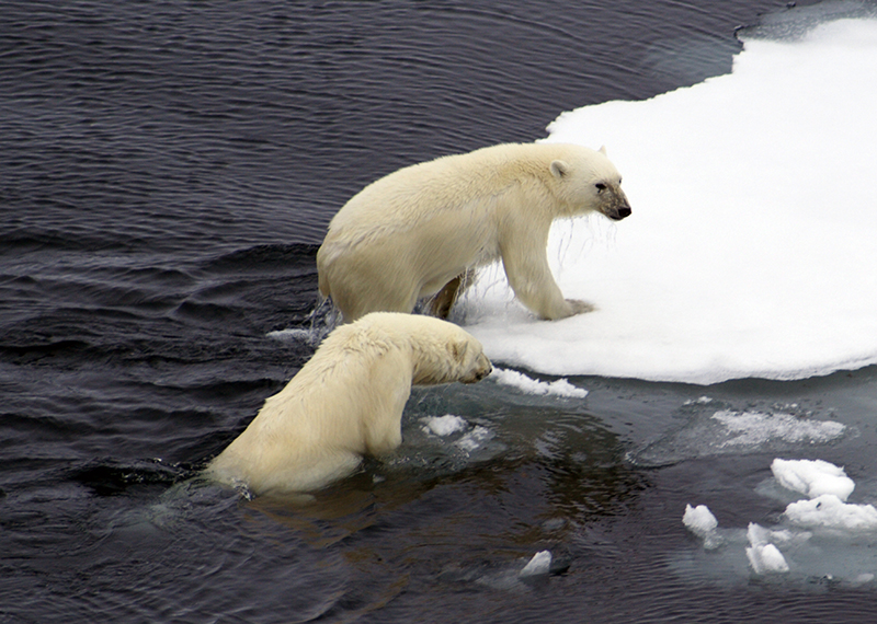
Figure 5 – Polar Bear Urcus arctos on Arctic sea cost close to Novosibirsk Islands, Aug. 17, 2005. Credit by Victoria Kshesinskaya
Russia is the world’s largest country by total area (land and water), the first by land and the second after Canada by water area. The country is very heterogeneous by most economic, social, cultural, environmental, geographic and climatic parameters, so that tools and approaches to govern and develop different regions should be adjusted to a regional specificity. The need to maintain the ecological stability of natural ecosystems and preserve biodiversity is an important task of the state, the practical implementation of which is carried out on the territory of the Russian Federation (Bocharnikov and Egidarev 2017).
…..amid highly variable regional structure of Russia, the policy and tools of environment protection needs regional adjustments or even completely different approaches based on local specificity and requirements.
Obviously, amid highly variable regional structure of Russia, the policy and tools of environment protection needs regional adjustments or even completely different approaches based on local specificity and requirements. In our study, we selected three fundamental wilderness features and evaluated a state of wilderness in different federal subjects. The idea was to divide a highly heterogeneous set of subjects into homogeneous groups, whereas the groups themselves are well-distinguished from each other. Such grouping of regions may allow similar approaches to wilderness preservation for closely related federal subjects. For example, values of the wilderness index (WI) ranged in a very narrow interval from 8.6 to 9.1 for five federal subjects in cluster D (Amur Oblast, Arkhangelsk Oblast, Jewish Autonomous Oblast, Irkutsk Oblast and Zabaykalsky Krai), though the corresponding regions are very distant with distances of about 8,000 kms from Arkhangelsk Oblast in the north-west of the European part of Russia to Amur Oblast and Jewish Autonomous Oblast in the Russian Far East. Therefore, urgent decisions and similar efforts of policy makers have to be undertaken in all these federal subjects to protect still remaining patches of wilderness (Figure 4).
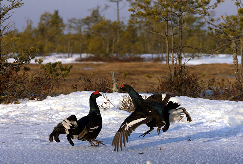
Figure 6– Common Grouse Lyrurus tetrix at spring nesting time bird games. Yugan State Nature Reserve. Western Siberia, March 12, 2016. Credit by Eugene Strelnikov.
We applied recently developed approaches to biodiversity preservation (Scheiner et al. 2017; Kosman et al. 2019) to the regions of Russia considered as separate elements that can be compared with each other based on the indicators of wilderness. One of such indicators was the singularity metric (Kosman et al. 2019), so that an extent of wilderness in terms of singularity was estimated for each region under consideration (Figure 4).
The map in Figure 7 shows the borders of 13 major economic macro-regions of the Russian Federation. Distribution of the regional singularity can be an alternative description of wilderness status on the entire Russia territory (see Bocharnikov and Egidarev 2016).
Our findings demonstrate the usefulness of the suggested techniques to comparative analysis of nature preservation in different regions, especially in the eastern part of Russia (Siberia and Far East; Figure 8). In particular, the singularity metric seems a suitable indicator of extent of wilderness status in a given region with respect to all other regions in question. Nevertheless, we intend to continue testing appropriateness of these approaches with larger sets of wilderness-related traits that allow more comprehensive characterization and evaluation of different aspects of nature conservation.
It can be noted that the economic space of Russia is represented by geographically oriented sectors: North and North-West of the European part of Russia, Central and Southern Russia, the Ural-Volga region, and huge territory of Siberia and Far East in the Asian part of Russia. The latter areas located to the east of the Ural Mountains are generally sparsely populated and the least economically developed territories of Russia with about 50% of saved wild nature. Most Russian wilderness (91.4%) is concentrated in its Asian part, mostly covered by tundra, boreal and mountain landscapes (Bocharnikov 2019). In the European part of Russia, still existing spots of wild nature are extremely limited except the North and North-Eastern regions with wilderness up to 50% (Figure 7).
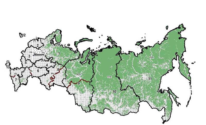
Figure 7– Economic regions of Russia: 1 – Northern; 2 – Northwestern; 3 – Central; 4 – Volga-Vyatka economic region; 5 – Central Black Earth economic region; 6 – Volga economic region; 7 – North Caucasus economic region; 8 – Ural economic region; 9 – West Siberian economic region; 10 – East Siberian economic region; 11 – Far Eastern economic region; 12 – Kaliningrad economic region; 13 – Crimea economic region. Proportion (%) of wilderness area (if exists) within a region is also shown.

Figure 8– Map of Eastern Russia demonstrates the most wilderness within Ural, Siberia, and Far East regions, where traditional life and activity of indigenous peoples are still supported.
A special consideration is needed in study of wilderness and its protection along borders between different countries (for example, the thousand kilometers of border between China and Russia). Comparison of existing protected areas in China and Russia demonstrated considerable differences between these two countries due to, perhaps, natural distinctions in social and economic activities as well as in interior policy of the neighboring countries (Bocharnikov et al. 2020). A proper evaluation and effective management of wilderness at adjacent areas of different countries need also universal or at least compatible tools and methodology; a few such new approaches were suggested in our study.
Conclusions
Specially protected territories are a traditional and highly effective form of nature and environment preservation in Russia. However, the internationally accepted ‘wilderness’ category should also be put into official use in Russia to form a legislative basis for preserving large territories in Siberia, Far East and Arctic, and still existing patches of wild nature in other regions. Classification of wilderness status in different regions is a highly important issue for policy makers to clearly determine objectives of nature protection, to shape proper feasible ways of reaching those objectives, and to efficiently manage sites of biodiversity conservation. New tools of wilderness data analysis used in this study can facilitate development of problem-oriented solutions of nature preservation.
About the Authors
VLADIMIR BOCHARNIKOV is the leading researcher at the lab for wildlife ecology and conservation of the Pacific Institute of Geography Far Eastern Branch of the Russian Academy of Sciences; email: vbocharnikov@mail.ru
EVSEY KOSMAN is a professor at the Institute for Cereal Crops Improvement, School of Plant Sciences and Food Security at Tel Aviv University; email: kosman@tauex.tau.ac.il
References
Bituykova V. 2019. Assessing of the Ecological Status in Regions of Russia and Neighboring Countries In: Current Trends in Landscape Research. Muller Lothar and Frank Eulenstein (Eds.) Springer Innovations in Landscape Research. P. 253 – 285.
Bocharnikov V. N., and E. G. Egidarev. 2015. “Dikaya priroda” – novyy prirodookhrannyy indeks dlya territorii Rossii (Wilderness is new indicator for the assessment of the existing anthropogenic transformation on the territory of Russia ). Problemy regional’noy ekologii Problems of Regional Ecology 5:75-80. (In Rus).
Bocharnikov V. N. 2016.Geoprostranstvo “dikoy prirody” Rossii (Wild Russia Geospace). ARGO Bulletin 5: 165-175. (In Rus.).
Bocharnikov V. N. and E. G. Egidarev. 2016. Ecologo-geographicheskoye kartographirovaniye ekonomicheskogo prostranstva Rossii na osnove technology GIS (Ecological and Geographical mapping of Russian economic regions based on GIS technologies). Vestnik Volgogrskogo gos. un-ta. Ser. 3, Ekon. Ekol. (Bulletin of Volgograd State University. Series 3, Economy. Ecology) 3:163-176. (In Rus).
Bocharnikov V. N. 2016. Dikaya priroda i antropogennyy landshaft: integral’nyy opyt geoinformatsionnogo kartografirovaniya territorii Rossii (Wilderness and anthropogenic landscape: an integral experience of geoinformation mapping of the territory of Russia)// Geograficheskiy vestnik, 2: 161-173 (In Rus).
Bocharnikov V. N. 2017. Dikaya priroda I osobo okhranyaemyye prirodnye teterritorii (OOPT) Sibiri (Wilderness and nature protected areas (PA) of Siberia). In: V.M. Kotlyakov, A.A. Chibilev and Tishkov, A.A. (eds) Voprosy geografii. Sb. 143. Geograficheskiyeosnovyzapovednogodela (k 100-letiyu zapovednoy sistemy Rossii) (Questions of geography. Collection of papers. 143. Geographical bases of the nature reserve management (to the 100th anniversary of the Russian Nature reserve system). Moscow: Kodeks Publ. House. 106-133. (In Rus).
Bocharnikov, V. N, and E. G. Egidarev. 2017. Dikaya priroda v landshaftakh I ekoregionakh Rossii (Wilderness in landscapes and ecoregions of Russia). Geografiya I prirodnyye resursy (Geography and Natural Resources) 4:38-49. (In Rus).
Bocharnikov V. N. and F. Huettmann. 2019. Wilderness Condition as a Status Indicator of Russian Flora and Fauna: Implications for Future Protection Initiatives. International Journal of Wilderness 25(1): 26-39.
Bocharnikov V. 2019. Concepts and measures for maintaining wilderness and landscape biodiversity in the Anthropocene. In Current trends in landscape research. L. Mueller, F. Eulenstein (eds). Cham, Switzerland: Springer.
Bocharnikov V. N., S. Dong, M. Zhao, and L. Zehong. 2020. Reconstruction Of A System Of National Parks And Protected Areas In China And Russia According To New Demands And Challenges Facing Implementation Of The Belt And Road Project. Geography, Environment, Sustainability 13(3) 76-84. https://DOI-10.24057/2071-9388-2018-56
Bukvareva E., D. Zamolodchikov, and K. Grunewald. 2019. Ecosystem Services of Russian Landscapes. In: Current Trends in Landscape Research. M. Lothar and F. Eulenstein (Eds.) New York: Springer.
Carver S., and S. Fritz. 2016. Mapping wilderness: concepts, techniques and applications. New York: Springer.
Drenthen, M. and Keulartz, J. (Eds.). 2014 Old World and New World Perspectives in Environmental Philosophy. Transatlantic Conversations. In: The International Library of Environmental, Agricultural and Food Ethics. Vol. 21. New York: Springer.
Ibish P. L., M. T. Hoffman, S. Kreft, G. Pe’er, V. Kati., L. Biber-Freudenberger , V. M. Dellasala, P. R. Hobson, and N. Selva. 2016. A global map of roadless areas and their conservation status. Science 354(6318): 1423-1427.
Kosman E., K. R. Burgio, S. J. Presley, M. R. Willig, and S. M. Scheiner. 2019. Conservation prioritization involving trait-based metrics illustrated with global parrot distributions. Diversity and Distributions 25: 1156–1165.
Mateo J.M., E.V. da Silva and M.B. Burgui. 2019. The Legacy of Sochava: The Theory of Geosystems. Open Access Journal of Environmental and Soil Sciences. DOI: 10.32474/OAJESS.2019.02.000147
Sanderson E.W, M. Jaiteh, M. A. Levy, K. H. Redford, A. V. Wannebo, and G. Woolmer. 2002. The human footprint and the last of the wild. Bioscience 52(10):891-904.
Scheiner S. M., E. Kosman, S. J. Presley, and M. R. Willig. 2017. Decomposing functional diversity. Methods of Ecological Evolution 8: 809–820.
Sochava V. B. 1978. An Introduction to the Theory of Geosystems, Novosibirsk: Nauka, 319 p. [in Rus.]
Read Next

Ambition: The Power of a Big Idea and Sticking to it
Protecting Half of Earth’s land and seas requires the power of persistence, truth and relationships.
Preserving the Wildness of Wilderness in the Anthropocene
Wildness: What is this evocative and elusive, primal and unquantifiable quality of Wilderness? Why is it so threatened in the non-analogue future we face? Why and how should we perpetuate it?
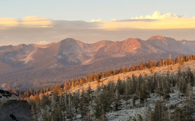
The Evolution Of Management Science To Inform Carrying Capacity Of Overnight Visitor Use In The Yosemite Wilderness
To avert overcrowding, mitigate biophysical impacts, and ensure quality wilderness experiences, managers utilize a suite of management tools, including inventories and assessments of wilderness campsite and social conditions, to evaluate changes to use and condition over time.