The Aldan “Golden” River in the Yakutia. Photo by Vladimir Bocharnikov
Wilderness Condition as a Status Indicator of Russian Flora and Fauna: Implications for Future Protection Initiatives
Science & Research
April 2019 | Volume 25, Number 1
PEER REVIEWED
ABSTRACT In Russia, three large federal districts in the Asian part of the country hold the majority of the remaining large areas of undisturbed contiguous flora and fauna, totaling more than 9 million square kilometers (3,474,919 sq. miles; 54.6% of Russia). Wilderness is largely perceived as areas of untouched, or so-called virgin, nature, which in ecological terms contains relatively undisturbed natural animal and plant populations where ancient ecological processes prevail. In areas where urban lifestyles now dominate in Russia, there is a reduced likelihood of daily interactions with such nature, and this increases the need and necessity to experience such interactions.
Wilderness can be a place that only exists in our imagination. It’s usually a place that is truly experienced by only a small fraction of society who either can afford to travel to undeveloped places, or who live there in isolated conditions (Figure 1). Although wilderness is thought of as a place, or places, today it is also a legal or zoning designation (i.e., a sociopolitical overlay) of a biophysical space. It can be recognized and legislatively protected by governments. The few remaining wilderness places of the world are increasingly sought after.
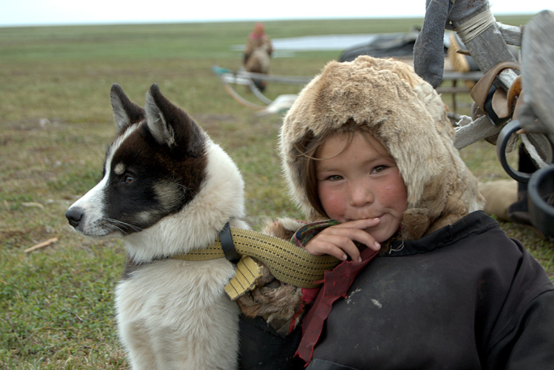
Figure 1 –Young nenets girl with dog in the Yamal peninsula. Photo by Victor Slodkevich.
Wilderness is often idealized as an undisturbed, pristine space in “harmony”, a place where we can escape the pressures and spaces otherwise dominated by humans and their actions. In Western philosophical literature, concern about wilderness infringement and loss appeared almost two centuries ago in North America, when the scale of the extermination of wild animals and the transformation of their habitats by European settlers and colonists became rather obvious and of concern (Kormos et al. 2015). However, it took more than a century and a half before this concept really became ingrained in the world’s environmental community and became accepted as one of the strictest forms of protected natural areas. To protect something for wilderness character suggests maintaining the area relatively free from significant anthropogenic impact but also protected for human experiences of high-integrity nature and its ancient but ongoing and globally important ecological processes.
Although protection efforts are increasing, there is a decreasing trend in the area of such natural places on the planet. In these protected places, the unknown is protected as being more valuable than what is already familiar. Throughout the world – and to a very large extent in Russia – the Arctic, the taiga, and the high mountains and deserts are often perceived by the “Western world” as the most pristine wilderness areas on Earth (Huettmann 2012). That is usually due to their remoteness and subsequently very low level of anthropogenic influence (cf, Klein and Magomedova 2003). In this study we investigate and illustrate the low level of human influence on wilderness character of a large part of Russia, with special consideration of the Arctic (Spiridonov et al. 2012) as high priorities for additional protection.
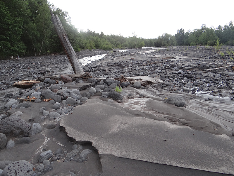
Figure 2 – The cold and muddy Studenya River is the only river flowing west of the volcanic Tolbachik. Tolbachik is a “volcanic complex on the Kamchatka Peninsula in the far east of Russia. It consists of two volcanoes, Plosky (flat) Tolbachik (3,085 m) and Ostry (sharp) Tolbachik (3,682 m), which as the names suggest are respectively a flat-topped shield volcano and a peaked volcano. Photo by Vladimir Bocharnikov.
A Spatial Assessment of Wilderness Character Based on Ecosystem Integrity
Around the world, wilderness is commonly defined by the absence of permanent habitation and roads, and, most importantly, by lack of modern economic activity, which otherwise causes large-scale transformations, injury, and violation of natural ecosystems (Casson et al. 2016). There have been several global, continental, and national wilderness assessments (cf, Lesslie at el. 1988; Cao et al. 2017), but the criteria for these large-scale mapping exercises varies.
Wilderness represents areas shaped largely by natural forces in contrast to areas shaped by humans, although most areas of the world are now believed to be affected by climate-induced disturbance, as well as contaminations, noise, and invasive species and diseases, many of those are moving across borders. The traditional wilderness concept views wilderness as an objective place separate from humans, primarily shaped by natural forces and free from human inhabitants and structures (e.g., McCloskey 1966) (Figure 2). The reason for such a view is probably the modern dominating Western culture that has been built as a human-nature (culture-nature) dichotomy; alternatives to this model exist, however. Roderick Nash (2001), for instance, suggests instead that wilderness is best understood using the conception of a spectrum of conditions or environment, ranging from the purely wild on the one end to the civilized or industrial-urban-rural surroundings on the other.
Because the modern concept of wilderness has been primarily a cultural or political one, the scientific foundation for wilderness is still being established, and is often lacking. The first step proposed here is to understand it as one part of larger landscapes of inhabitation. Wilderness instantiates a unique form of human-land relations, and wilderness “boundaries” reveal their permeable and fluid nature; it is usually a wilderness gradient. A geospatial analysis of Russian wilderness suggests that these areas are “empty,” as judged by a modern economic point of view. Wildland preservation, however, tends to be motivated by a variety of ethical, biological, cultural, and recreational concerns. Rarely are efforts to protect wildlands motivated by an interest in promoting economic growth (Huettmann 2014). Those working on wildland preservation issues have often been forced to consider the issue of local economic impacts, but that’s because those supporting commercial development of those wild natural landscapes emphatically assert that wildland preservation damages the local and national economies by restricting access to valuable natural resources and constraining commercial economic activity. A great deal of research in North America suggests otherwise (Christensen 2011).
Efforts described in this investigation focused on obtaining a highly generalized but realistic representation of the current degree of anthropogenic disturbance in the Russian Federation. We focus on original results from assessing the degree of anthropogenic disturbance to landscapes of the Russian Federation on the basis of geographic information systems (GIS) technology. We acknowledge that wilderness and wilderness definitions are complex and somewhat problematic across cultures, certainly on a global scale. Therefore, it may present particular difficulties for mapping and GIS, both of which depend on carefully defined attributes and discrete criteria (Carver et al. 2012).
Methods
Using GIS software (ESRI ArcGIS10.2) and data, this assessment conducted for Russia starts with the recognition of a unified spatiotemporal continuum: one pole of which is represented by a virgin (immune from human management and impact) natural environment (wilderness), while the other pole of geographical space is considered as the cultural landscape, developed territories, and urbanized areas.
We then used widely applied geoinformation standard quantitative analyses showing (in absolute terms and as a percentage) large tracts of off-road and uninhabited (or nearly uninhabited) areas, as well as anthropogenically disturbed areas.
A “wilderness index” was calculated by the simple formula (Bocharnikov and Egidarev 2015):
- Rast = ΣΣ(SPrdor + ΣSPlpos) * + ΣΣZnbf + ΣΣSPlpin / OPtre, where:
- Rast = the current state of the remaining large wilderness areas of the Russian Federation;
- ΣSPrdor is the total area of the Russian “roadless areas”;
- ΣSPlpos is the total area of the settlement of all types;
- ΣZnbf is buffer zone, created by GIS standard buffer procedure, and ranging from 1 to 60 kilometers (.62 to 37 miles) (see Bocharnikov and Egidarev 2015);
- ΣSPlpin is the total area of all types of industrial infrastructure and linear industrial facilities (power lines, pipelines, etc.); and
- OPtre is the total area of the administrative territorial unit subject or physiographic country or landscape ecological macroregion.
The working scale of our research is based on vector topographic maps of Digital Chart of the World Data (DCW) 1:1,000,000 scale pixel resolution, which was upgraded by the Russian company DATA+ in 2002. The methodological approach of work in US and European wilderness assessments has been based on the identification of five main features that are considered to be most characteristic of wilderness: (1) off-road territories, (2) officially existing protected areas, (3) spatially contiguous across our analysis area to serve as ecologically based indicators of biodiversity and/or landscape connectivity, (4) indigenous lands, and (5) recreational areas used for “primitive” recreation. For Russia, we were able to apply most of these features.
The first component of the analysis consists of the calculation of integral sites, permanently uninhabited and virtually unused by humans. Settlements, industrial areas, and infrastructure, including all forms of human development (land and inland water transport, communications of all types, power lines, pipelines, etc.) are excluded. The parameters for the calculation of the areas of obvious human influence – a buffer of the contact zones of the major transforming environment – shapes human interaction and is the prime directive. The algorithm of approximate calculation (the application of the “coarse filter” of display of the “unpopulated” territory) shows land plots within which exist no permanent settlements and lack industrial enterprises (including extracting and processing), transport, or communication infrastructure of any kind (e.g., highways and railways, power lines, oil and gas pipelines, and other large objects indicating economic activity).
The second component of the analysis is the identification of areas that have a high level of preservation of natural features. Mostly this means an area has an official federal, regional, and local protected area status. The overwhelming evidence from many case studies and reviews around the country demonstrates that wildlands and biodiversity protection is an overall positive net economic benefit to communities and to regional economies as well as contributing to an enhanced quality of life.
We are not including in our wilderness inventory of Russia some other possible criteria, such as known high biodiversity or best wildlife habitat areas, as well as indigenous lands and wilderness tourism areas. That is because such accounting asks for more detailed information than was available. But more attention was given to what a wilderness area means for Russian ecosystem services and natural capital. We also consider that correct visualization of the actual socioeconomic situation of the country on the basis of the proposed integral indicator allows for a new “look” at the specifics of spatial distribution of resources, labor, services, and culture. It will help us understand the real role of Russian regions in the development of economic and ecological space (Figure 3).
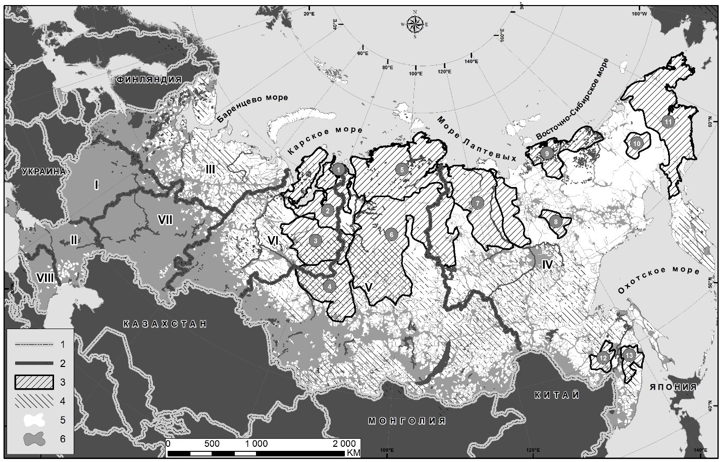
Figure 3 – The current distribution of human influence, federal districts (okrug), and large natural Russian roadless areas. Legend: 1 – border of the Russian Federation; 2 – Russia Federal District (okrugs) borders (Roman numerals); 3 – large areas of wilderness (Arabic numbers in circles); 4 – high-integrity roadless areas; 5 – low-integrity human-influenced areas; 6 – hard anthropogenic-changed (human-influenced) areas.
For a minimal, noneconomic impact of the territory, this information comes from plots of not less than 50,000 hectares (123,553 acres), which made it possible to show a very detailed picture of economic “development” of the whole territory of Russia. The calculation of areas and drawing of contours was carried out through the use of standard software GIS functions (see Figure 3). We calculated wilderness conditions within the boundaries of official “net” administrative-territorial divisions.
Results
Our small-scale cartographic analysis of the territory of Russia was able to describe the levels of intact landscapes and their protection. Figure 1 shows the result of our index and filter application to wilderness regions in Russia.
When mapping very large areas of wilderness, along with the impacts of the consequences of economic development, strong patterns quickly become evident. Dominating areas are found for southern Siberia and the south of the Far East, but also in central Siberia and the northeast of Russia.
The idea of protecting wilderness character in Russian areas, to meet IUCN (International Union for the Conservation of Nature) Protected Area Category 1b requirements (Casson et al. 2016) has been expressed before. It has a long history. However, the wilderness idea has not found much popularity in Russia itself, remaining little known in most Russian scientific and conservation circles (Bocharnikov 2017). Major conservation gains could still be made, however, by effectively protecting these remote and widely unrecognized zones. Protecting these remote areas presents both unique challenges and promising opportunities. Russia has an opportunity to preserve and study the standards of nature and ecological processes, requiring minimum intervention by humans (Lavrenko et al. 1958; Zapovedniki Sovetskogo Soyuza 1977; Shtilmark 2001).
Discussion
Our results, as shown in Figure 3, show convincingly that human influence within Russia is far from uniform: the largest area of dense settlement is located in the European part of Russia (from 60 degrees north to the southern borders of the country), to the east (the band of intense settlement somewhat narrows toward the Urals and beyond, and widens again with more intense settlement from Novosibirsk to Tomsk, Kuzbass, and Altai, and further narrowing along the Trans-Siberian, and those industrial zones created in the last centuries). There is an obvious east–west gradient, and the Russian Far East (Huettmann and Gerasimov 2006; Huettmann 2008 for the Sea of Okhotsk), and the Arctic offers large areas of wilderness, although development corridors can be found, for example, roads and the Siberian railways (see Huettmann et al. 2011, 2012; Spiridonov et al. 2012) for Arctic shipping.
These characteristics are not commonly understood in ordinary general education maps, in educational atlases, on many thematic maps, or in reference books. We consider most important, in our calculations of Russia wilderness, the still-existing wild areas. Attention must be drawn to the fact that large wilderness areas (10,000 sq. km/3,861 sq. miles and more) exist. But mostly they are just found in the territory of Asian or “Eastern” Russia, with other very fragmented natural landscapes within the “northern territories” of the European part (Bocharnikov and Egidarev 2017).
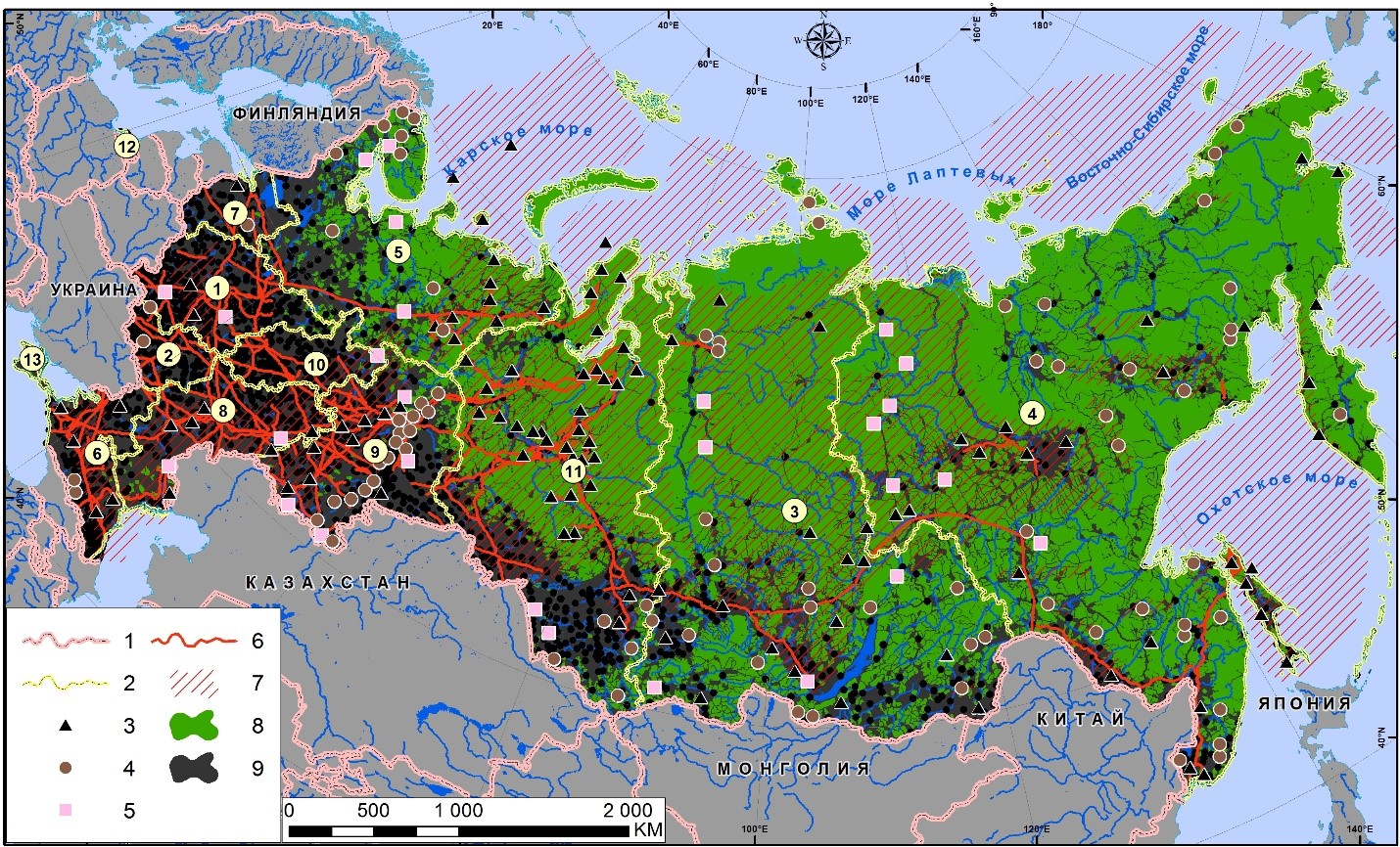
Figure 4 – Map of Russia illustrating differences between European and south Siberian areas with high population density and “prosperous” industrial areas. Legend: 1 – country borders; 2 – federal district (ocrug) borders; 3 – large coal deposits; 4–5 – gold and other metal deposits; 6 – main oil and gas pipelines; 7 oil and gas deposits; 8 – off-road areas; 9 – anthropogenic areas with high levels of landscape conversion. All sources for our mapping are public and can be found on site of Russian Geology Service. Map created by Vladimir Bocharnikov, GIS-specialist Eugene Egidarev
This pattern becomes obvious even from this quick assessment and comparison of the territories that we are considering here in the wider grid of the administrative and territorial division in the federal districts. In the European part of Russia, the area of wild nature that is significant and comparable to the Asian part of the country is only located in the Northwest administrative district (Figure 4). This district has preserved almost half of its territory in a low anthropogenic impact state (48.1% of the total area), including the last large old- growth forests in the European part of the Russian Federation. In contrast, in the Central, Southern, and Privolzhsky districts – situated in the western part of Russia – only 3% remains as wilderness. In southern Russia are situated the North Caucasian and Southern Federal districts. Those – such as in the recent past a special Crimean region – contain only small biodiversity hot-spot areas with intact wilderness patches (some generally preserved in remote mountain areas) with a total of only about 1.9% and 6.7% of the total area, respectively.
Certainly this situation deserves a more accurate assessment in the near future, especially to separate remote historically populated areas from lands under agriculture during the last two centuries. We must take into account Russia as a whole as well as its federal district differences. That’s because under modern economic conditions we need to know what the real value of wilderness for Russian governance with global repercussions is. For example, according to our accounts among Russian Arctic residents, the differences in the relationships and ratios between people and high-integrity nature can differ by many orders of magnitude. In Karelia there are 8.5 hectares (21 acres) of wilderness per person (in Arkhangelsk oblast, 15 ha/37 acres; Murmansk oblast, 29 acres ha; Komi Republic has 33 ha/81 acres per person). But in contrast with such levels, on Chukotka, this ratio of wilderness per person reaches many times higher (e.g. 1,351 ha/3,338 acres per person).
We should mention here specifically that the Nenets Autonomous District is also among the Arctic leaders in intact wilderness. Accordingly, we found that each resident has 540 hectares (1,334 acres) of wilderness, whereas Yakutia has about half of that with 269 hectares (665 acres) (Figure 5), but which is still twice that in the Yamal-Nenets district, where it is only 114 hectares (282 acres) per person. And if we consider the large “middle Russia region” referred to as the Krasnoyarsk oblast, there are about 87 hectares (214 acres) of wilderness found per person (Bocharnikov and Egidarev 2016).
With a historical perspective in mind, we need to emphasize the major conservation gains achieved by the Soviet Union by effectively protecting nature reserve systems within inhabited areas. But that is not the case in these remote zones; only a few exceptions exist. The recent analysis of the existing Russian network of protected areas (Prisyazhnaya et al. 2016) shows that, despite all its undisputed merits and dignity, this network is very unevenly distributed across the country; it is also very uneven in terms of the size of the protected areas, and most have with poor infrastructure.
One should probably highlight that the protected areas (PA) system in Russia was designed by convenience and with a stark historic legacy, but not with modern principles and tools of strategic conservation planning. It therefore offers itself to improvements, which is an international characteristic of most PAs worldwide, oceans included. However, besides lack of a sustainable funding scheme, the biggest flaw in Russia’s existing PA system is probably its insufficient representation in both geographical representation and in regard to specific types of landscapes and soils. The preservation of nature and eternal inviolability of the territory of nature reserves were laid out and defined with a strong foundation by the Soviet Russia government decrees of 1920–1924. By 1950 there were 128 strict nature reserves in Russia; the total area was then approximately 0.56% of the country (Sokolov 2006).

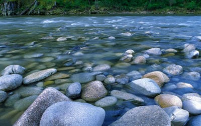
Figure 5 – The Aldan “Golden” River in the Yakutia. Photo by Vladimir Bocharnikov.
However, a network of nature reserves continued to grow, and additional land areas were essentially protected simply by remoteness and lack of access, as seen in the eastern parts of Russia. But the eternal inviolability of the territories of nature reserves became gradually under pressure, and we should say that with increasingly neoliberal economic conditions many of the pragmatic environmental ideas have lost their original Russian protected-areas principles and foundation. It is important to stress here the differences between existing wilderness conditions and the extent of the official PA system (see Figure 6).
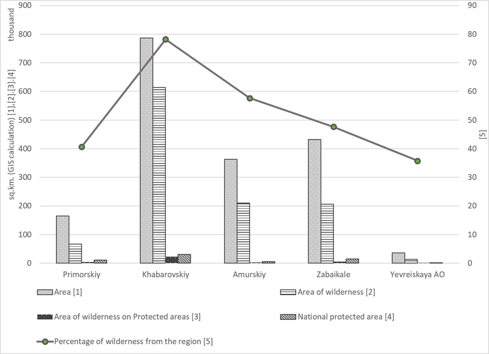
Figure 6 – Wilderness areas and level of protection in the Russian part of the Amur River basin.
We should mention here that strict nature reserves (zapovednik) became a reality and justified for their limited use for the protection in the reserves of economically useful species. Obviously, further development of the network of reserves and national parks in Russia – arguably one of the largest and last wilderness areas in the world – needs a serious adjustment. That’s because it serves not only Russian national interests but also global interests (Figure 7).
Figure 7 – Siberian moose of western Siberia in the Yugansky Nature Reserve. Photo by Olga Strelnikova.
Another important point of our findings from Russia’s wilderness assessment lies in the context of transboundary issues, which have great geopolitical importance. This is especially true in the south of the Russian Far East (see Figure 6 for details), such as within the Amur River basin. Along this great river basin (it ranks third when based on its total river length for Asia), there are state borders with four countries, including North Korea. There are no science-based comparisons yet between wilderness areas for each country, but the first step for Russia has been made, and it shows important wilderness areas in the far eastern transboundary Russian districts.
In conclusion, we have presented the first modern accounting of Russian wilderness for conservation planning, with all of Russia included. Within large regions there are many benefits from all types of nature use, including hunting, fishing, and harvesting of wild plants, as well as recreational activities and tourism. We can state that in contrast to many other countries, in Russia we can still find large wilderness areas not only in their “naturalness” state but also wildlife habitats that have been maintained without special government efforts. Really large wilderness areas, in total about 4.8 million square kilometers (1,853,290 sq. miles) of the Far Eastern Federal okrug remains relatively intact, where the share of natural areas is 78.3% (an incredibly high number, globally speaking). Russia hosts many of the world’s wilderness assets.
“We can state that in contrast to many countries elsewhere, in Russia we can still find large wilderness areas not only in their ‘naturalness’ state but also wildlife habitats that have been maintained without special government efforts.”
The vast territories of wild nature that are preserved in Russia for the whole planet are not so rich in resources. But they play a vital role in maintaining global ecological balance, and it’s not yet recognized by Russia or the world community to its full potential. Put in context, we need to remember that the three poles concept (where the majority of ice and snow is located in the world, providing for the world’s heat balance) (Huettmann 2012) suggests the globally important Arctic, Antarctic, and Himalayan Mountain areas all support the ecological balance of Eurasia and the world at large.
VLADIMIR BOCHARNIKOV is a research biologist with the Pacific Institute of Geography of the Russian Academy of Sciences, Far East Division, Vladivostok; email: vbocharnikov@mail.ru.
FALK HUETTMANN is faculty in the Biology and Wildlife Department, Institute of Arctic Biology at the University of Alaska–Fairbanks (UAF); email: falkhuettman@alaska.edu.
References
Bocharnikov V. N. 2017. Dikaya priroda I osobo okhranyaemyye prirodnye teterritorii (OOPT) Sibiri (Wilderness and nature protected areas [PA] of Siberia). In Voprosy geografii. Sb. 143. Geograficheskiye osnovy zapovednogo dela (k 100-letiyu zapovednoy sistemy Rossii) (Questions of Geography. Collection of Papers. 143. Geographical Bases of the Nature Reserve Management (to the 100th Anniversary of the Russian Nature Reserve System), ed. V. M. Kotlyakov, A. A. Chibilev, and A. A. Tishkov (pp. 106–133). Moscow: Kodeks Publishing House. (In Rus).
Bocharnikov V. N., and E. G. Egidarev. 2015. “Dikaya priroda” – novyy prirodookhrannyy indeks dlya territorii Rossii (Wilderness is new indicator for the assessment of the existing anthropogenic transformation on the territory of Russia). Problemy regional’noy ekologii (Problems of Regional Ecology) 5: 75–80. (In Rus).
———. 2016. Ecologo-geographicheskoye kartographirovaniye ekonomicheskogo prostranstva Rossii na osnove technology GIS (Ecological and geographical mapping of Russian economic regions based on GIS technologies). Vestnik Volgogrskogo gos. un-ta. Ser. 3, Ekon. Ekol. (Bulletin of Volgograd State University. Series.3, Economy. Ecology) 3: 163–176. (In Rus).
———. 2017. Dikaya priroda v landshaftakh i ekoregionakh Rossii (Wilderness in landscapes and ecoregions of Russia). Geografiya i prirodnyye resursy (Geography and Natural Resources) 4: 38–49. (In Rus).
Cao, Y., Y. Long, and R. Rang. 2017. Research on the identification and spatial distribution of wilderness areas at the national scale in Mainland China. Chinese Landscape Architecture 33(258): 26–33.
Carver, S., A. Comber, R. McMorran, and S. A. Nutter. 2012. A GIS model for mapping spatial patterns and distribution of wild land in Scotland. Landscape and Urban Planning 104 (3/4): 395–409.
Casson, S. A., V. G. Martin, A. Watson, A. Stringer, and C. F. Kormos. 2016. Wilderness Protected Areas: Management guidelines for IUCN Category 1b protected areas. IUCN World Commission on Protected Areas (WCPA). Retrieved from http://winapps.umt.edu/winapps/media2/leopold/pubs/930.pdf.
Christensen, N. 2011. Local economic importance of designated wilderness: Evidence in the literature. International Journal of Wilderness 17(3): 24–27.
Huettmann, F. 2008. Marine conservation and sustainability of the Sea of Okhotsk in the Russian Far East: An overview of cumulative impacts, compiled public data, and a proposal for a UNESCO World Heritage Site. In Ocean Yearbook 22, ed. M. Nijhoff (pp. 353–374), Halifax, Canada.
———, ed. 2012. Protection of the Three Poles. Tokyo: Springer.
———. 2014. Economic growth and wildlife conservation in the North Pacific Rim. In Peak Oil, Economic Growth, and Wildlife Conservation, ed. E. Gates and D. Trauger (Chapter 4). Washington DC: Island Press.
Huettmann F., Y. Artukhin, O. Gilg, and G. Humphries. 2011. Predictions of 27 Arctic pelagic seabird distributions using public environmental variables, assessed with colony data: A first digital IPY and GBIF open access synthesis platform. Marine Biodiversity 41: 141–179. doi 10.1007/s12526-011-0083-2.
Huettmann, F., and Y. Gerasimov. 2006. Conservation of migratory shorebirds and their habitats in the Sea of Okhotsk, Russian Far East, in the year 2006: State-of-the-art and an outlook. Stilt 50: 23–33.
Klein D. R., and M. Magomedova. 2003. Industrial development and wildlife in Arctic ecosystems. In Social and Environmental Impacts in the North: Methods in Evaluation of Socio-Economic and Environmental Consequences of Mining and Energy Production in the Arctic and Sub-Arctic, ed. R. O. Rasmussen and N. E. Koroleva. NATO Science Series (Series: IV: Earth and Environmental Sciences), vol. 31. Dordrecht, Netherlands: Springer.
Kormos, C. F., B. Bertzky, T. Jaeger, Y. Shi, T. Badman, J. Hilty , B. G. Mackey, R. A. Mittermeier, H.
Locke, E. Osipova, and J. E. M. Watson. 2015. A wilderness approach under the World Heritage Convention. Conservation Letters. September.
Lavrenko E. M., V. G. Heptner, S. V. Kirikov, and A. V. Formozov. 1958. Perspektivnyy plangeograficheskoy seti zapovednikov (proyekt) (Perspective planning geographic network of reserves [project]). Okhranyayemoyeprirodyizapovednoyedelo v SSSR (Protected by nature and protected in the USSR). Bul. 3. Moscow: AN SSSR. 3–92.
Lesslie, R. G., B. G. Mackey, and K. M. Preece. 1988. A computer based methodology for the survey of wilderness in Australia. Environmental Conservation 15: 225–232.
McCloskey, M. 1966. The Wilderness Act of 1964: Its background and meaning. Oregon Law Review 45: 288–321.
Nash, R. 2001. Wilderness and the American Mind. New Haven, CT: Yale University Press.
Prisyazhnaya A. A., O. V. Chernova, and V. V. Snakin. 2016. Razvitiye systemy osobo okhranyaemykh prirodnykh territorye (OOPTP – osnova sokhranenuya biologicheskogo raznoobraziya prirodnykh kompleksov) (Development of nature reserved areas network: The basis of conservation of biological diversity of natural systems. Space and time 11(1).
Shtilmark F. R. 2001. Absolyutnaya zapovednost’ – posledniy oplot real’noy okhrany dikoy prirody (Absolute reserve – the last stronghold of real wildlife protection). Gumanitarnyy ekologicheskiy zhurnal (Humanitarian Ecological Journal) 3: 111–113.
Sokolov, V. Ye. 2006. Biosfernyye zapovedniki: tselii problemy (Biosphere reserves: Goals and problems). Lektsii laureatov Demidovskoy premii (1993–2004) (Lectures of the winners of the Demidov Prize [1993–2004]). Ekaterinburg, retrieved from http://www.aif.ru/dontknows/file/zapovednaya_sistema_rossii_spravka (In Rus).
Spiridonov V., M. Gavrilova, Y. Krasnov, A. Makarov, N. Nikolaeva, L. Sergienko, A. Popov, and E. Krasnova. 2012. Towards the new role of marine and coastal protected areas in the Arctic: The Russian case. In Protection of the Three Poles, ed. F. Huettmann. Tokyo: Springer,
Zapovedniki Sovetskogo Soyuza (Natural Reserves of the Soviet Union). 1977. Moscow. Lesnaya promyshlennost’ Publishing House.
Read Next
Personal Restraint and Responsibility for Protected Areas in Crisis
“How can a society champion the public good in one instance, and yet willfully damage and undermine that same good in another?”
Wilderness Was Not America’s New Idea: Exploring a New Wilderness Stewardship Ideal at the 2018 National Wilderness Workshop
As tribes across the United States seek to regain their sovereignty and access to ancestral lands and ecosystems, we as managers can be visionary and create a management model that extends beyond a seat at the table.
Did #MakeYourSplash Make a Splash?
In 2018, we celebrated the 50th anniversary of the birth of our Wild and Scenic River System. Created in 1968 with only eight rivers, the system has grown to include more than 12,000 miles (19, 312 km) and over 200 protected rivers.