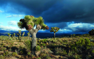
Hiking the PCT in Southern California Photo credit © Justin Helmkamp
Multi-jurisdictional collaborative management of the Pacific Crest, National Scenic, and John Muir Trails
Science & Research
August 2020 | Volume 26, Number 2
Information about visitor use in parks and protected areas is an essential component of effective management (Cessford and Muhar 2003). Data about recreation users has long been recognized as important for several reasons, including the ability to manage budgets, personnel, protect resources, and to provide visitors with enjoyable experiences (Manning 2010). Useful visitor information for managers includes data on visitor counts, type of visitor use (e.g., primary activity), timing of use (e.g., season), indicators and thresholds of quality, and rule compliance (Manning 2010; Marion, 2016; Cahill et al. 2018). Previous studies also indicate that it is beneficial for managers to understand characteristics of users, including activity type (Manning 2010). Activity type can influence visitors’ temporal and spatial distributions, impacts on natural resources, or user conflicts (Jacob and Schreyer 1980; Kyle, Graefe, Manning, and Bacon 2003). The Pacific Crest Trail (PCT) runs 2,650 miles along the mountain ranges of California, Oregon, and Washington, connecting America’s borders with Mexico and Canada. It is designated as a National Scenic Trail (NST) and along with the Appalachian and Continental Divide National Scenic Trails, is considered one of the “Triple Crown” long-distance trails in the United States. The PCT runs through numerous public land units (e.g., seven National Parks, twenty-six National Forests, four Units of BLM land, five State Parks, and forty-eight federally designated Wilderness areas) and overlaps with other trails and routes (e.g., John Muir Trail [JMT] and the Tahoe Rim Trail). Therefore, the PCT is both a stand-alone NST and a part of the trail networks of many other areas and designations.
Over the past decade, long-distance use (i.e., trips that are 500 miles long or longer) of the PCT has increased dramatically. In 2019, approximately 8,000 long distance PCT permits were issued, and nearly 1,000 users reported a completed thru-hike (PCTA, 2020). Thru-hike completion numbers have risen by an order of magnitude in the past decade. The increases in PCT use align with increases in use of the national parks and forests through which the PCT runs. Combined, the national park and forest systems received nearly 500 million visits in 2018, which is approximately 15% higher than use levels from a decade before (US Forest Service, 2018; US National Park Service, 2020). While this recreation provides numerous health and economic benefits, the volume of use and its rapid growth is placing management pressures related to crowding, conflict, environmental damage, and administrative burden and coordination on the region’s public land managers and neighboring communities.
Use pressure within the Central Sierra has been particularly high between Mount Whitney and Tuolumne Meadows where the PCT and JMT are coincident. In this area, the trails cross through eight unique federally managed public land units. These include the National Park Service administered units of Yosemite National Park, Devils Postpile National Monument, and Sequoia and Kings Canyon National Parks. Additionally, the trails cross through US Forest Service administered units including the Inyo, Sequoia, Humboldt-Toiyabe, Eldorado and Sierra National Forests. Together these public lands encompass over two-million acres, 176 miles of the PCT and the entirety of the 211-mile JMT. Federally designated Wilderness areas account for approximately 95% of this land area. In addition to direct federal management of recreation along the PCT in these units, several non-profit and NGO partners including the Pacific Crest Trail Association (PCTA) contribute to the region’s collaborative management system. Boundaries of each land unit are porous as visitors travel and recreate utilizing hundreds of miles of trails that allow for relatively seamless backcountry experiences.
With high visitation levels throughout the summer, permit systems are used throughout the region to balance recreational access with resource protection and conservation mandates. These systems limit the number of overnight users accessing wilderness lands to protect environmental and experiential character from use-created impacts. Acquiring these unit-level permits to enable a long-distance trip along the PCT can be challenging. To ease this challenge and facilitate the experiences for which the PCT was designated as an NST, a long-distance travel permit, administered by the PCTA on behalf of the USFS, allows PCT travelers on trips of greater than 500 miles to travel and camp on the PCT without the need to secure individual unit-level permits.
Together, these permit systems create a mosaic that simultaneously created diverse recreation opportunities and ever shifting management challenges. As units adapt their own permit systems to address unit-specific issues, their actions influence the conditions and permit system operations of surrounding units, which often adapt in response. The overlay of the PCT long-distance permit creates complexity as PCT users travel through land management units in ways that are unaccounted for by unit-level permitting and management systems. The ad hoc nature of responses and interaction effects have highlighted a need for collaboration among trail and land managers to coordinate their actions. This article documents this collaborative process and how research and analyses are being leveraged to support informed adaptive management of the PCT and JMT.
Methods
The research and analyses we describe here were guided by, and conducted in direct response to, prioritized needs expressed by PCT and JMT managers. The process began with review and organizing of existing information, identifying critical gaps, and analysis and synthesis of the available information to inform collaborative discourse on visitor use management across the region. The process resulted in three areas of research and analysis: 1) compilation of wilderness permit data; 2) synthesis of permit systems in the central Sierra Nevada; and 3) analysis of annual surveys of PCT long-distance permit holders.
Compilation of Wilderness permit data
Each federal land unit in the PCT/JMT area uses overnight permit systems to manage wilderness camping. These unit-administered wilderness camping permit systems generate a wealth of information about visitor use along the PCT/JMT including group and trip characteristics, use estimates along trails and in camping areas, and changing patterns of visitor use. In 2017, researchers and land managers compiled this permit-derived information from individual units and assessed: 1) the potential for integrating the data into an area-wide dataset; and 2) its suitability for modeling visitor use along the PCT/JMT. Compilation was based on identifying common variables and data formats within the multiple unit-level permit datasets. Examples of these variables included the start and end dates and locations of trips, group sizes and types, and planned itineraries.
Synthesis of permit systems: the Central Sierra Nevada
To better understand the administrative operations and constraints that shape each unit-level permit system, the research team conducted structured interviews with wilderness permit managers from the Eldorado, Humboldt-Toiyabe, Inyo, Sierra, and Stanislaus National Forests and Sequoia, Kings Canyon, and Yosemite National Parks. The interviews elicited information about the structure and operations of permit systems, any limits to visitor use that are imposed by the permits and the underlying rationale for limits, and the methods used by units to coordinate permits that cross jurisdictional boundaries. Table 1 presents the question areas addressed in the interviews. Results from the interviews were synthesized to document the characteristics of each permit system and their interactions.

Table 1 – Permit System Interviews & Synthesis
Analysis of PCT long-distance permit holders
To better understand the travel patterns and behaviors of long-distance permit holders, the PCTA administered a survey to every adult PCT long-distance permit holder between 2016 and 2019. Long-distance permit holders were recruited to participate at the end of the travel season (i.e., late autumn) by email and data was collected using an online questionnaire. This survey gathered information on each long-distance traveler’s prior long-distance trail experience, group characteristics, travel patterns (i.e., trip and trip-segment starting and ending dates and locations), visitation to key locations in the PCT/JMT areas (e.g., Mount Whitney, Yosemite Valley), and time spent off the trail during long-distance trips. Based on results from the 2016 and 2017 surveys, the questionnaire was revised in 2018 to better collect information on the travel patterns of trips with multiple major segments (i.e., “flip-flop” or discontinuous trips) and resupply behaviors in the PCT/JMT area. Table 2 presents details about PCTA’s survey responses.
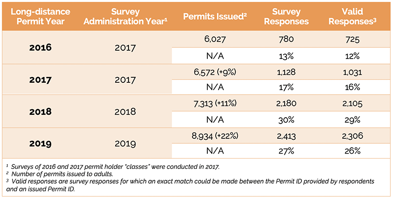
Table 2 – PCT Long-distance Permit Holder Survey Population & Responses
Primary analysis sought to distill information on actual travel patterns and behaviors of PCT long-distance travelers to answer questions about how actual travel patterns differ from those implied in permit applications. To explore these topics, trip and trip-segment starting and ending dates and locations from the survey were analyzed to create computational models of visitor travel for each year of the survey. The models use the reported start and end time and location information to estimate average travel speeds for each respondent. These travel speeds are applied to the reported start dates, start locations, and durations of each segment of each respondent’s trip to estimate how many respondents are expected to have camped on any given section of the PCT on each night of the travel season. These expected use levels were weighted by survey response rates to represent the full population of long-distance permit holders and to calculate estimated daily densities of long-distance permit holders along the PCT.
Results
Compilation of Wilderness permit data
Efforts to compile data collected by area units’ permit systems into a comprehensive and coherent dataset revealed disparities in detail, quality, and accessibility among the various permit systems. Each system collects different variables (i.e., some systems collect full itineraries while others have only trip state date and location), store data in different formats (e.g., paper forms, local databases, web-hosted databases), and has different data extents (i.e., years and seasons covered). These differences highlight two challenges to leveraging this information for management. First, the task of creating a single, consistently formatted dataset for common analysis of all historic permit data would take significant time and effort and the resulting database would have substantial gaps and caveats. Second, managers were collaborating based on incomplete and assumed knowledge about the nature of and relationship among the different permit systems.
Synthesis of permit systems: the Central Sierra Nevada
The difficulties encountered compiling and using permit data revealed a need for a systematic documentation and understanding of the area’s unit-level permit systems. Interviews with permit system managers provided insights about the permits’ operations, administrative constraints, and the ways the systems integrate beyond each unit’s boundary.
The scientific and management rationale for the permit systems were established and revised at different times (i.e., from the 1970s until the present) and in response to different pressures (e.g., crowding, conflict, environmental damage). Following their establishment, most of the systems have adapted at an operational level in response to changing conditions and circumstances. Some of these adaptations have been motivated by changing visitor use patterns, others have been in response to the consequences of management actions implemented by other units in the region. For example, as individual units implement unit-level permit actions (e.g., Inyo National Forest’s Whitney Portal exit permit, Yosemite National Park’s Donahue Pass exit permit), PCT and JMT users quickly adapted their travel patterns in ways that created new management issues elsewhere (e.g., beginning trips at low-use locations, increasing popularity of northbound JMT trips).
Wilderness permitting in the PCT/JMT overlap area is variable at the operational level. The methods used to apply for and receive permits and the types of information that must be provided when applying for a permit differ by unit. Some permits are available online and others only by an in-person visit to a ranger station. Some require specification of a planned itinerary, while others do not. Some limit lengths of stay in particular areas, while others allow groups to overnight wherever they please. Additionally, there are not standardized or codified systems for recognizing the validity of permits across the region. Although all land management units in the PCT/JMT overlap area are seamlessly connected by trails, all units do not recognize the validity of each other’s permits. Although a great deal of difference and diversity was found among permit systems, the interviews also confirmed a commitment to communication and collaboration among units. Permit managers in the area regularly communicate with each other, and informal or ad hoc communication has matured into regular and organized collaboration.
“Significant differences emerged in the data between wilderness and trail conditions based on the intended behaviors reported at the time of permit application and the actual behaviors of long-distance travelers reported through the PCTA survey.”
Analysis of PCT long-distance permit holders
Significant differences emerged in the data between wilderness and trail conditions based on the intended behaviors reported at the time of permit application and the actual behaviors of long-distance travelers reported through the PCTA survey. Much of the divergence between intended behaviors and actual behaviors was legitimate and common (e.g., hikers ending their trips early because of injury, illness, or changing motivations; planned timing and routing changing in response to safety concerns related to snow and fire). However, some of it was not legitimate (e.g., using PCT long-distance permits for trips of less than 500 miles) or was unexpected (e.g., permit holders taking long periods of time off the trail during their trips).
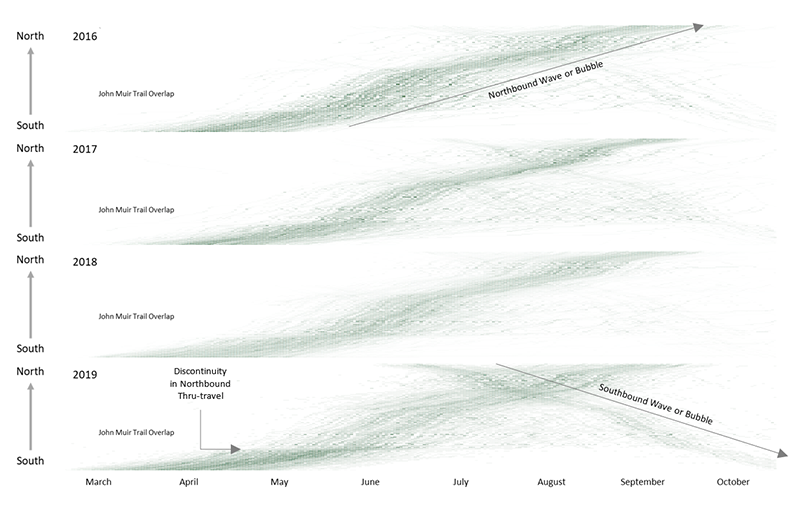
Figure 1 – Estimated Density of PCT Long-distance Permit Holders along the PCT: 2016 – 2019
Survey derived travel pattern models highlighted times and locations where long distance travel use was high, patterns of attrition for the seasonal northbound thru-hike “bubble” (i.e., northbound thru-trips that end earlier than planned), and how travel patterns changed from year to year in response to environmental conditions (e.g., snow and fire), management actions (e.g., permit regulations), and social conditions (e.g., crowding, trail culture). Modeling and estimation of the density of PCT long-distance permit holders revealed trail-wide travel patterns and changes in these patterns over time. Figure 1 depicts four years (2016-2019) of modeled travel patterns. For each year, days of the long-distance permit holder season are arrayed along the X-axis and sections of the PCT between trail access points are arrayed along the Y-axis. The darkness of each cell (i.e., each day and section combination) increases as the estimated number of permit holders increases, from a minimum of zero to a maximum of approximately 20 permit holders per mile.
Examination of these model estimates yield the following insights about PCT long-distance traveler behavior.
- A primary northbound wave of long-distance travelers passes along the PCT beginning at the southern terminus in April and ending at the northern terminus in September. In the early season (i.e., March, April, and May), northbound long-distance permitted thru-trips typically seek to balance passing through the southern California desert early in the season before summer heat begins while also allowing adequate time for mountain snows to melt and associated flooded watercourses to calm. A limit of 50 trip starts per day at the southern terminus prevents the number of northbound travelers from growing too large and seeks to spread use evenly throughout the period. Late in the season, travelers seek to reach the northern terminus before autumn storms begin and temperatures drop in the northern Cascades.
- In years with high snow levels (e.g., 2017 and 2019), there is a greater amount of long-distance permit holder use of the Central Sierra region of the trail in July, August, and September. This use pattern is the result, in large part, of northbound travelers initially bypassing sections of the trail to avoid lingering snow and associated flooding in the Sierra Nevada and returning to the area later in the summer and autumn when trail conditions are more favorable for travel. This is seen in the discontinuity in the primary northbound wave just south of the PCT/JMT overlap, particularly in years with heavy spring snowpack. The discontinuity is evidence that the northbound traveler wave or bubble is disturbed and broken-up by heavy or late-season snow in the Sierra Nevada mountains.
- In 2019, a distinctly concentrated wave of southbound hikers emerged. The strengthened southbound wave is likely the result of several factors including, among others, saturation of northbound thru-permits, which are limited at 50 per day during the primary trip start season. Additionally, anecdotal evidence suggests a response among some thru-travelers to changing experiential conditions along the PCT, in which travelers who are seeking greater levels of solitude are choosing to make southbound trips to avoid traveling within the prominent northbound traffic.
Understanding the interactions between these trail-wide travel patterns and federal land management units was one of the core objectives of the permit holder survey. Figure 2 displays the travel pattern data provided by survey respondents specifically for the PCT/JMT overlap. The line graph presents expected average daily density of long-distance permit holders per mile for 2016 through 2019. For each year, the proportion of total permit holder density attributable to single leg trips (i.e., conventional continuous thru-trips) is depicted. The table presents the estimated daily average number of long-distance permit holders present in the PCT/JMT area for each week of the primary travel season. These analyses highlight significant changes in PCT traveler behavior in this area over the past four years. Since 2016, the peak density of PCT long-distance permit holders expected to be in the PCT/JMT area at one time had steadily decreased, a nearly 50% decline between 2016 and 2019. This reduction in peak pressure when the northbound bubble or wave of PCT long-distance travelers passes through the area may be positive news for managers. However, this reduction in peak pressure is accompanied by increased long-distance permit holder presence later in the year during the primary unit-level visitor use season. This increases the functional pressure (i.e., direct interaction between PCT long-distance travelers and unit-level users) placed on units by long-distance travelers. It is the product of increasing numbers of PCT long-distance travelers breaking their trips into multiple segments, with northbound thru-hikers skipping the Sierra Nevada mountains in the early summer and returning later when travel conditions are more favorable. Ultimately, although the maximum number of PCT long-distance travelers present along the PCT/JMT at one time has declined, more long-distance travelers are using the trail each year.
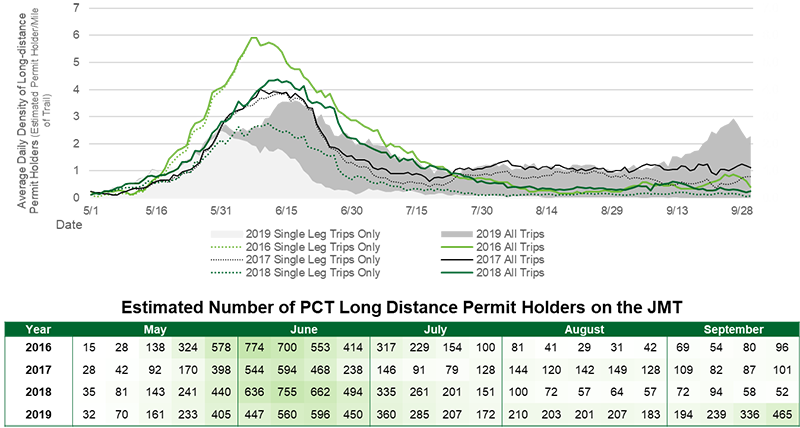
Figure 2 – Estimated PCT Long-distance Permit holder Use in the John Muir Trail Area
Discussion and Conclusion
Collaborative Research Strengthens Management
We have presented diverse analyses conducted in direct response to a priority need collaboratively identified and expressed by the trail and land managers. Together, the analyses have documented visitor use conditions and tracked changes from year to year, informed collaborative adaptive management, and strengthened the capacity of the management community of practice along the PCT. Long-distance and national scenic trails, including the PCT, are dynamic recreational settings. Environmental conditions, especially those related to snow and fire, vary from year to year. They influence when and where long-distance travelers are present on the trail and, consequently, when and where long-distance travel interacts with unit-level visitor use and resource management. Social conditions also vary from year to year. Some of this social variation is responsive to management actions (e.g., changes in permit requirements) and some is the product of forces outside the control of trail and land managers (e.g., social media, third-party information sources, global travel and experience trends). Regardless of the source, trail and land managers benefit from accurate and up-to-date understanding of long-distance traveler behavior and how these traveler characteristics relate to environmental and management conditions.
By collaborating with each other and their stewardship partners, trail and land managers of the PCT/JMT have systematically leveraged existing data, new data, and scientific analysis to document changing trends in use of the PCT and PCT traveler behavior over a critical four-year period. Specific examples of these trends include understanding the influence of snow levels in the Sierra Nevada mountains have on delaying the northbound wave or bubble of thru-travelers and stimulating multi-segment trips and the emergence of a distinct southbound bubble as quotas for northbound travel become exhausted.
Synthesizing data along the PCT, particularly in the JMT area, have informed adaptive management of the PCT and its interaction with the federal land units the trail traverses. Adaptive management of the PCT and adjacent lands begins by developing an operational understanding of user behavior on the trail and the broader regional system of public lands. The research and analysis presented above helped to build this understanding from both an administrative (e.g., permit data compilation, permit system synthesis) and visitor use (e.g., long-distance permit holder survey) perspective. PCT/JMT trail and land managers’ understanding of existing conditions is used to identify, plan for, and implement necessary management actions through a collaborative process. Examples of the resulting management actions include enhancement and coordination of safety and impact-reduction information, education, and communication; revision of long-distance permitting quotas and regulations; and expansion and consistency data collection including ranger and volunteer patrols, trail registers and counters, and permit holder surveys. The effects of these actions on trail use and users were then monitored and evaluated during successive years of data collection and analysis (e.g., annual permit holder surveys, collaborative management deliberation). The results of these multi-year analyses support PCT and JMT trail and land managers to further refine and adapt their management approaches and generate insights into how trail use and conditions may change in the future.
Along with the technical contributions made by the research and analysis described, it has also been a key to growing the collaborative community of management practitioners along in the PCT. Through their collaborative activities, PCT and JMT trail and land managers have grown both the body of knowledge available for management and their capacity for using knowledge to improve management. This capacity building includes the extension and strengthening of professional relationships the enable collaboration and the expansion of processes for integrating science, data, and analysis in management.
In this article we have illustrated the ways that applied science and data analysis can inform long-distance and national scenic trail management in responsive and collaborative ways. The research and analytical activities we discussed leveraged existing information and partnerships. Support responded directly to the expressed needs of managers and help managers adapt to changes in visitor use and administrative constraints. Additionally, science and data supported collaboration and development of a cohesive management community in the PCT/JMT area.
About the Authors
NATHAN REIGNER, PhD, is a research assistant professor in the Recreation, Park, and Tourism Management Department at the Pennsylvania State University; email: npr5097@psu.edu.
JEREMY WIMPEY, PhD, is Principal of Applied Trails Research and an adjunct faculty member in the Forest Resources and Environmental Conservation Department at the Virginia Polytechnic Institute and State University; email: jeremyw@appliedtrailsresearch.com.
References
Pacific Crest Trail Association. 2020. PCT visitor use statistics. Retrieved June 15, 2020 from https://www.pcta.org/our-work/trail-and-land-management/pct-visitor-use-statistics/
US Forest Service. 2018. National Visitor Use Monitoring Survey Results National Summary Report. Retrieved June 15, 2020 from https://www.fs.usda.gov/sites/default/files/2019-09/5082018_national_summary_report_070219.pdf;
US National Park Service. 2020. Visitation Highlights. Retrieved June 15, 2020 from: https://www.nps.gov/subjects/socialscience/highlights.html;
Read Next
Foundation and Future of Long Distance Trails
We begin this special edition of the International Journal of Wilderness with references to the U.S. Wilderness and National Trails System Acts to illustrate the significance and interconnectedness of wilderness areas and long-distance trails.
With Collaboration We Can Overcome Challenges Together
The concepts of “shared stewardship” or “collaborative management” can be challenging. They require shared vision, definition of clear roles and responsibilities, and commitment to the collaborative process.
Shared Stewardship and National Scenic Trails: Building on a Legacy of Partnerships
National Scenic Trails connect people with the natural and cultural heritage of the United States. Theses trails also provide important opportunities for agencies to engage partners in trail stewardship and sponsorship.