Photo credit © Katie Orlinksky
Managing Cultural Resources On The Alaska Peninsula
Science & Research
August 2020 | Volume 26, Number 2
PEER REVIEWED
ABSTRACT
Twentieth-century cultural resources provide physical evidence of human relationships with a landscape that has shaped the wilderness areas we know today. These cultural resources enrich the meaning of an area as wilderness, but also present multiple management challenges surrounding visitor use in designated wilderness areas. The National Geographic Society Katmai Expeditions of the 1910s present a case study of how historic trails and their associated artifacts interact not only with present issues toward the dual-enforcement of the National Historic Preservation Act and Wilderness Act, but also with the management of visitor use along a corridor containing relatively recent traces of historically significant activities and events. This study draws on the findings of a 2018 expedition identifying convergence of a historically significant trail with a popular path for backpackers through the Katmai Wilderness and explores the importance of cultural resources in long-distance trail planning and cultural resource management in designated wilderness.
Across the Wilderness Preservation System, there is an increasing interest by federal agencies in the management of contemporary cultural resources—those left behind “by hunters, traders, miners, settlers, and travelers” (Cowley et al., 2012 p. 29). However, of the innumerable paradoxes that exist in federal land management policy, perhaps none is more confounding than the competing resource preservation goals of the Wilderness Act and the National Historic Preservation Act (NHPA). Both pieces of legislation seek to preserve areas and objects from humankind’s fervor to develop, yet the Wilderness Act largely excludes the preservation of human-made objects—the primary goal of the NHPA. Thus, land managers are left with a choice in the management of cultural resources in wilderness areas: ignore the strict provisions of the Wilderness Act and preserve cultural resources or ignore the provisions of the NHPA and disregard cultural resources altogether.
This study examines the policy and management complexities of preserving twentieth century cultural resources in wilderness areas that intersect long-distance trails by providing an example from Katmai National Park and Preserve, Alaska. Following the format of qualitative, exploratory case-study research, we address how legislation and recent debates about the dual-enforcement of the NHPA and Wilderness Act might inform future management decisions surrounding the protection of cultural resources along long-distance trails extending through protected wilderness areas (Yin 2003).
This examination provides examples of decisions regarding the management of a growing class of cultural resources (twentieth century materials) that have only recently become part of the archaeological record. Often, the recency of significant events and phenomena associated with such cultural materials has precluded them from inclusion in the designation of wilderness character on U.S. public lands, limiting their protection in the management plans of specific protected areas. The case of a recently rediscovered historic trail through Katmai National Park was selected to examine how current national and region-specific legislation may be used in the development of new wilderness narratives and mitigation strategies for the protection of significant cultural resources and history previously omitted from this national park’s management plan. This representative case study about the management of historic resources at Katmai National Park and Preserve provides a significant contribution to the limited pool of available literature on the dual-enforcement conflict that is currently available to resource managers seeking to address similar issues elsewhere.
Relevant Legislation
The relevant legislation outlined here refers specifically to laws protecting cultural resources and wilderness character in the context of national park lands (NPS-specific policies) and federally-owned lands in Alaska (Alaska National Interest Lands Conservation Act) that are specifically relevant to our case study. For further discussion of designations of historic and cultural resources and policies intended to protect wilderness character refer to DeSantis (2020) and Landres et al. (2015)
Antiquities Act of 1906
In response to acts of vandalism seen at archaeological sites across the U.S. Southwest, Congress provided the first official measure of protection to cultural resources on public lands by enacting the Antiquities Act of 1906. This act prohibits the excavation of antiquities on all U.S. public lands without a permit from the Secretary of the Interior (King 2008). This was the first piece of major legislation to firmly establish research and education as valid goals of public land management in the United States. In addition, the Act authorized the creation of National Monuments on public lands that are especially significant to science (Sellars 2007).
Organic Act of 1916
The Organic Act of 1916 created the National Park Service (NPS) to mandate the protection of scenery, natural history, cultural history, and wildlife in public park lands for future generations. As such, the NPS was the first federal agency to be charged with maintaining the integrity of both natural and cultural resources on public lands, setting a precedent that other federal land-management agencies would subsequently follow (Ross 2013). The Act calls for the setting aside of public lands for both recreation and conservation purposes, with the caveat that current enjoyment should not impair that potential for generations to come. As cultural resources are nearly always non-renewable, it is this policy that managers consider when weighing the informative potential or educational value of a given resource against the potential risk of its destruction (National Park Service 1998).
Wilderness Act
In 1964, President Lyndon Johnson signed the Wilderness Act—defining parameters public lands must meet for inclusion in the National Wilderness Preservation System. The first of these requires that a Wilderness area “generally appears to have been affected primarily by the forces of nature, with the imprint of [hu]man’s work substantially unnoticeable.” The fourth—and last parameter—concedes, however, that lands may also contain “historical value.” This fourth parameter provides the basis for much of the cultural resource preservation in Wilderness, as will be discussed.
The Alaska National Interest Lands Conservation Act (ANILCA)
While the policies set forth by the Wilderness Act are generally still applicable in Alaska, they are occasionally superseded by regulations proposed in the Alaska National Interest Lands Conservation Act, established in 1980. This complex piece of legislation was primarily intended to provide rural residents with access to subsistence resources and permit the continuance of traditional activities, but has inadvertently provided further protection to archaeological resources and standing structures within wilderness areas (see ANILCA , Subchapter I and Section 1315). Specifically, ANILCA conflicts with the protection afforded to wilderness areas elsewhere in the United States by allowing for the use of motorized boats and planes in designated wilderness, as well as the construction and maintenance of hard-sided structures for overnight shelter (Landres 2017).
National Historic Preservation Act
In 1966, President Johnson signed the National Historic Preservation Act (NHPA)—expanding the National Park Service’s (NPS) ability to catalog and preserve “places that represented historical events, archaeological sites, and historic buildings” (Kirn 2013, p. 53). The NHPA also established the National Register of Historic Places (NRHP), which gives the NPS the authority to establish and preserve historic “districts, sites, buildings, structures and objects that are significant in American history, architecture, archeology, engineering, and culture” (NPS 1988, p. 2). To be eligible for listing on the NRHP, a resource must meet two basic criteria: 1) be significant (through a relationship with an important event or person, their embodiment of a particular type, period, or method of construction, or in their potential to yield further information about history and prehistory); and 2) have enough integrity to continue communicating its significance (in other words, the site or structure cannot be too damaged to demonstrate its own significance or potential) (36 CFR 60.4).
In 1972, President Nixon signed executive order 11593, extending the same degree of protection to any cultural resource found on federal lands that were merely deemed eligible for listing on the National Historic Register (even if the resource was not yet listed on the register). This order has been critical to ensuring a legally protected status to sites immediately after their assessment by a qualified professional—potentially years ahead of an official acceptance of a nomination to the National Historic Register (King 2008). A further revision made to the NHPA in 1980 expanded the same policy of protection to encompass all cultural resources—those attributes of a place relating to social identity—beyond legally defined districts or sites to include the preservation of ethnographic resources and cultural landscapes in addition to archeological resources, structures, and museum objects (National Park Service 1998).
These two revisions have had a few significant consequences for the way that most public agencies now protect cultural resources.First, nomination to the NRHP generally contributes little additional protection to sites on federal lands already maintaining sufficient integrity and informative potential to be considered for nomination (Sebatian 2009). For example, Fannie Quigley’s House, located in Denali National Park, was only added to the NRHP in late 2019 (NRHP Ref # 100004765). Built around 1907, the structure is only slightly older than Denali National Park itself and has been maintained and protected by the NPS for the better part of a century (Norris 2006). Secondly, it has elevated cultural resources on the register to holding a sort of ‘honorary’ status by establishing a public record articulating why a place, phenomenon, or history is so important that the public really should know about it (King 2008). This honorary status may confer the benefit of additional funding for preservation purposes through federal programs and grants (Sebastian, 2009). Lastly, this approach also has the occasional drawback of subjecting many sites to unintentional damage by users of public lands who have no knowledge of their existence or significance (Ryan 1999). Often, those responsible for their preservation see the safest option as steering people away from them. In the case of a trail that is itself a resource, strategies implemented by park managers might focus on limiting the damage inflicted upon adjacent and associated archaeological sites through trampling, erosion, climbing on structures or moving artifacts (Wildesen 1982). Effective strategies used by cultural resource managers include restricting traffic around archaeological sites to pedestrian use only and developing and maintaining a clear footpath with signage and amenities nearby (Palumbo 2002). However, when not executed carefully, such additional developments and amenities have the potential to detract from an area’s wilderness character.
National Trails System Act
Finally, in 1968, President Johnson signed the National Trails System Act (NTSA) “to provide for the ever-increasing outdoor recreation needs of an expanding population and in order to promote the preservation of, public access to, travel within, and enjoyment and appreciation of the open-air, outdoor areas and historic resources of the Nation.” This legislation includes elements of both the Wilderness Act and the NHPA. For instance, designated National Scenic Trails are to “provide for maximum outdoor recreation potential and for the conservation and enjoyment of the nationally significant scenic, historic, natural, or cultural qualities of the areas through which such trails may pass.” Since this time, archaeologists have increasingly adopted the perspective that, while trails do lead people to cultural resources, their strategic placement may also function as an effective tool for minimizing impact to a site (Lipe 2009).
Relevant Case Studies
Previous attempts to balance the Wilderness Act, the NHPA, and—in some cases—the NTSA have ended with mixed results. The management of the Phillip Burton Wilderness of Point Reyes National Seashore provides perhaps the most controversial example. Watt’s (2002) analysis of the area’s contentious 1976 wilderness designation concludes that a purposeful erasure of the land’s relatively recent history of ranching and dairy production was required for the area to meet wilderness eligibility. Existing ranch buildings and barns were removed or burned and the NPS reported to Congress that the area had been left “unaltered by the hand of man” (Watt 2002, p. 60). More recently, the wilderness garnered national attention after a 2013 federal court ruling upheld an NPS decision to not renew the historic oyster farming lease adjacent to the wilderness on the basis that it did not conform to the area’s wilderness character (Nagle 2014).
Cultural resource management along the Appalachian National Scenic Trail within the Shenandoah Wilderness provides another contentious example. Human impacts on the landscape are evident throughout the Shenandoah Wilderness (Cowley et al. 2012); as noted by Shaffer (2016), the Appalachian Trail through Shenandoah provides access to its abundance of cultural landscapes and resources. In fact, the trail’s significant standing in American lore as a uniquely American pilgrimage has transformed it into cultural landscape unto itself, where the trail and its accompanying structures and viewscapes purvey and preserve an important experience (Shaffer 2016). Until recently, however, the NPS largely ignored the presence of contemporary “mountain culture” artifacts along the Appalachian Trail through the Shenandoah Wilderness and the other areas of the national park to ensure compliance with the Wilderness Act—in spite of the high density of nineteenth and early-twentieth century homesites in the area (Gourley 2017). The NPS has now moved to catalog the “mountain culture” artifacts throughout the park and comply with all relevant policies (Gourley 2017).
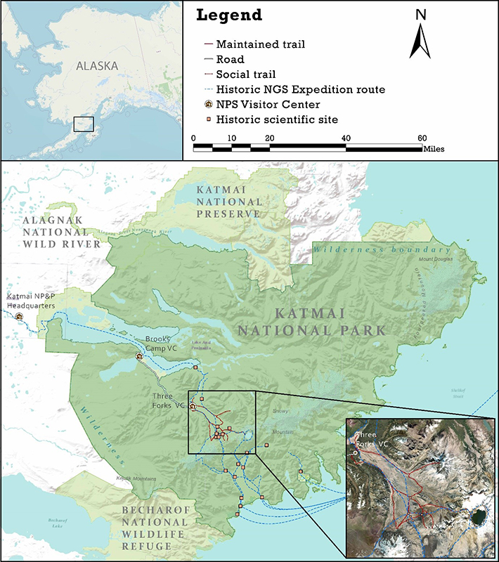
Figure 1 – Map of Katmai National Park showing historic National Geographic Society expedition routes, historic base camp and scientific site locations, park facilities and wilderness boundaries. instagram.com/p/BJNxxOQguqK/.
Examples of cultural resource inclusion under the “historical value” clause of the Wilderness Act can be found in the Chiricahua and Death Valley Wilderness areas (Crowley et al. 2012). The Chiricahua Wilderness—which is completely enveloped by the NHPA-protected Chiricahua National Monument Historic Designed Landscape—preserves retaining walls and historic structures related to the history of the Civilian Conservation Corps (Crowley et al., 2012). In Death Valley, artifacts including “mill sites, claim markers, aerial tramways, mine shafts…town sites… aircraft wreckage, abandoned roads, cabins (some still in use), rock walls, fences, gravesites, graffiti, survey markers, bearing trees, and many other things” (p. 116) are preserved and included in the wilderness character qualities of the park’s Wilderness Stewardship Plan (Death Valley National Park 2012).
The Death Valley Wilderness also provides a prominent example of how visitor trip planning can be influenced by relatively contemporary cultural resources. A recent study found that the trips of Death Valley hikers were—in part—motivated by an eagerness to engage with historical sites and learn about the cultural history of the area (Rice et al. 2019). Additionally, public input to the area’s 2012 Wilderness Stewardship plan revealed that “visitors value historic mining sites [and] there is concern that the park needs to provide access to historic mining sites and other historical mining remains” (Death Valley National Park 2012, p. 12).
The Case of Katmai Wilderness
In 1918, President Woodrow Wilson established Katmai National Monument on just over one million acres of the Upper Alaska Peninsula for the protection of the unique and highly active volcanic landscape created by the Mt. Katmai-Novarupta volcanic event of 1912 (Presidential Proclamation #1487). In spite of the Valley’s long pre-eruption history of use as a travel corridor by Alaska Native peoples and Euroamericans, the Monument’s original boundaries were drawn close to the edges of the volcanic devastation, as the primary resources to be protected were the scenic beauty and geologic resources of its famed Valley of 10,000 Smokes. Central to the efforts to explore and protect this area were the National Geographic Society (NGS) and their well-known leader of four expeditions to Katmai, Robert F. Griggs.
Figure 2 – Signage has been used by protected area managers to preserve contemporary cultural resources. Photo by Will Rice.
The four years Griggs years spent documenting the fumarole-ridden desert left behind by the Novarupta event resulted in numerous National Geographic publications recounting the expedition teams’ fantastic adventures and important scientific discoveries and directly influenced Wilson’s decision to protect Katmai’s landscape (Griggs 1917, 1918, 1921, 1922). For many, Griggs’ widely-distributed photographs and narrative of an ‘authentic’ discovery served to provide a more personal connection to this strange and far-away place (see Figure 3 for example). One century later, Katmai is still expensive, with guided tours, dining, and lodging drawing visitors from around the world—with approximately one quarter of visitors hailing from outside of the U.S. (Strawn & Le 2014).
Recognition of the area’s important cultural history, diverse wildlife, and pristine habitats prompted the boundaries of the Park and Preserve to expand to what they are today. All combined, protected lands at Katmai span an area larger than the entire state of Connecticut – nearly 5 million acres. Together with this tremendous growth in size came a host of management concerns. While Katmai is best known today as a sanctuary for Alaska Brown Bears or as a world-class destination for anglers and sportfishermen, the park also boasts an archaeological record amongst the richest in all of Alaska (Norris 2004). Over 240 archaeological sites have been documented within its boundaries, several of which represent large villages once occupied by hundreds of historic Alutiiq and ancestral Sugpiaq people (Dumond 2011). These concerns, and many others, converge most acutely at the Brooks River Archaeological District National Historic Landmark; also Katmai’s primary destination for bear viewing (Ringsmuth 2013).
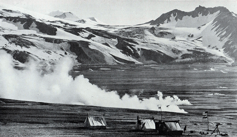
Figure 3 – Historic photo of the active fumeroles in Katmai’s Valley of 10,000 Smokes published in a 1921 edition of National Geographic Magazine; original caption reads: “The headquarters of the National Geographic Society’s latest Katmai expedition during its stay in the Valley of 10,000 Smokes” (Credit: National Geographic Society/Emory Kolb)
Outside of Brooks Camp, Katmai has only six miles of maintained trails, and, as a result of sweeping changes and expansions by ANILCA, over 95% of the park’s land lies in designated or eligible wilderness (Morris & Evison 1986). The majority of this wilderness is only accessible to the public by watercraft or small fixed-wing aircraft on floats or specialized landing gear, significantly limiting the range of places where visitors might go. Nevertheless, all of the cultural and natural resources found within the park’s wilderness areas are managed by a very small core staff working remotely from King Salmon, AK. The park’s enormous size and abundance of resources, combined with the arrival of visitors on planes departing from numerous airports in Southern Alaska make it impossible for this small staff to educate all visitors about potential encounters in advance of their visit, or even closely monitor adverse impacts to all of these sites on a regular basis.
Methodological Process
It was this history of early scientific exploration and conservation that our multidisciplinary team of scientists and storytellers sought to explore in 2018. In spite of the historical significance of these expeditions, the precise routes which these early explorers followed as well as the exact locations of their base camps remained unknown (Clemens & Norris 2008). By delving into the maps printed in various century-old editions of National Geographic Magazine, our team pieced together the approximate locations of the various base camps these expeditions used from 1915 through 1919, as well as the routes that they would have followed from Katmai’s Pacific Coast all the way across the Aleutian Mountains, through the Valley of to 10,000 Smokes and down to the Iliuk Arm of Naknek Lake—a waterway leading directly out to the Bering Sea (see Figure 2). Our goal was to identify the archaeological remains of their associated camp sites. Over the course of 34 days of backpacking, our team retraced the routes of these historic expeditions, visiting the sites of twelve different historic NGS expedition camps. Incidentally, the majority of the expedition’s travels were found by our project to overlay an extant historic trail known as the “Katmai Pass Route”, which had already been in use for hundreds, if not thousands, of years prior to its concealment by Novarupta’s massive ashfall.
Findings and Discoveries
Katmai’s primary destination for backpackers remains the Valley of 10,000 Smokes, which contains an extensive network of social trails that visitors manage to navigate on their own without direct guidance or amenities (Norris 1996). Included in this trail network are large sections of the historic Katmai Pass Route, along with numerous spurs leading to nearby mountains and geologic features once navigated by the NGS’s expedition teams. How many visitors to Katmai choose to follow these historic trails, how far they go, and what historic sites they interact with has yet to be investigated. “Backcountry” use of Katmai’s wilderness areas is facilitated through numerous commercial-use authorized (CUA) guiding services, not all of whom report their activities to the park. Unreported CUA visits have been estimated to raise the number of annual visitors by 16,000 people or more (Fay & Chistensen 2012). In 2014, 15% of park visitors stated that they visited the Valley of 10,000 Smokes, and 13% stated that they camped overnight in the Park’s backcountry (Strawn & Le 2014). If these percentages are transposed onto the number of visitors in 2019 (84,167 people), then the number of visitors taking extended backpacking trips in this area may be as many as 11,000 annually (NPS Visitor Use Statistics 2019). However, based on the authors’ own observations, the actual number of backpackers at Katmai is likely not this high and has not increased at the same rate as day-trip visitation to the park. Backpackers and hikers who follow the course of a well-worn social trail down from Katmai’s Three Forks visitors center, located near the northern boundary of the Valley of 10,000 Smokes are not informed that they are literally following in the footsteps of famous NGS explorers, trailblazers and prominent scientists who came before and after them.
Two century-old base camp locations documented along the historic NGS routes were found to contain archaeological features and artifacts scattered on their surface. Findings included a roll of film, portable chemistry equipment, a shell casing, camping gear, and many personal effects, such as socks and a hat pin—all scattered in clusters over a 100m area, as if they came from different tents (Figure 4). Beyond the NGS-associated findings, the 2018 expedition documented even more sites within the Valley of 10,000 Smokes linking this location to an era of scientific exploration that the NGS had spurred at Katmai (Stelson & Walton 2019). The expedition team also found evidence of researchers attracted by Griggs. For instance, two members of the NGS expedition of 1919 that later went on to become prominent geologists, carved their initials on stone at the base of the Novarupta volcano (Hildreth & Fierstein 2012; Figure 7). Inspired by Grigg’s original scientific work, Smithsonian Institute biologist Victor Cahalane established his own permanent vegetation monitoring plots around the valley in 1954 and the rebar stakes delineating their corners can still be seen today (Cahalane 1959). Taken in isolation, each of these features might appear to look like old garbage, graffiti, or dilapidated shacks, but together they are part of a long scientific legacy—the continuation of which can be seen in the occasional encounter of seismographs now maintained by the Alaska Volcano Observatory.

Figure 4 – The site of a National Geographic Society base camp used in 1917 and 1919. Findings such as the base of a scientific flask stand and crushed gaslight in the foreground provide clues to its antiquity and research-oriented purpose. Each pink flag marks an artifact. Photo by Laura Stelson.
Many visitors who choose to stay in the Valley of 10,000 Smokes overnight wind up having a very personal encounter with this scientific legacy by taking shelter in the now historic-age USGS research station known as the Baked Mountain huts—situated in the core of Katmai Wilderness (Figure 5). Constructed by USGS in 1965, and used by various geological projects for administrative purposes until 1982, these structures have served as a temporary shelter for those caught off guard by the valley’s powerful windstorms (Hildreth & Fierstein 2012). To be sure, these strange, musty shacks have always stood out against the natural landscape as functional rather than beautiful—complaints about their “unkempt” appearance, have been on record since 1969 (Norris 1996). Nevertheless, protection through their usefulness as the only form of shelter within a twelve-mile radius kept them standing for 52 years, and they might now even be considered an essential part of the Valley of 10,000 Smokes experience. In spite of their historic nature, the future of the Baked Mountain Huts (and the possibility of finding a hard-walled shelter beside the Katmai Pass trail) became significantly less certain after a storm caused two of the structures to collapse. As the most tangible and functional remnants of Katmai’s history of scientific exploration, their fate now rests in the managerial interpretation of the NPS wilderness and cultural resources management legislation outlined above.

Figure 5 – A historic USGS geologic research station known as “the Baked Mountain Huts” used as a hard-sided shelter by backpackers traveling through the Valley of 10,000 Smokes. Public use of the huts is currently discouraged due to their deteriorating state. Photo by Will Rice.
Implications for Management
Katmai staff have the unique challenge of managing designated wilderness under ANILCA policies, while also balancing the preservation of abundant cultural resources under the NHPA. In its intent to preserve traditional Alaskan subsistence strategies, ANILCA protects the practices of travel by motorized vehicles and the construction of hard-sided structures in Alaska’s designated wilderness areas. These stipulations present park managers in Alaska with additional challenges in defining wilderness character and assessing visitor impacts to sites in this region.
Evaluating the potential for damage to these relatively ephemeral cultural resources has become increasingly urgent as growing demand for adventure tourism drives ever more backpackers to remote and undeveloped locations such as Katmai’s wilderness (Huddart & Stott 2020). In 2019, visitor numbers at Katmai more than doubled from what was typical some five years earlier (NPS Visitor Use Statistics 2015-2019). The lack of guidance and amenities for visitors seeking to navigate the network of historic and informal tails throughout the Valley of 10,000 Smokes increases the vulnerability of the natural and cultural resources of this wilderness to accidental damage by visitors seeking to access ‘off-trail’ locations. To effectively combat such threats, an approach of mixed direct (i.e. physical barrier) and indirect (i.e. informative) methods for managing visitor impacts to cultural resources is recommended. Realization of this area’s significant history and cultural resources opens new possibilities for developing such a comprehensive strategy. Connecting with Katmai’s history of scientific exploration and tales of epic adventure by being guided along this known route may well enhance the adventure experience for long-distance trail hikers, while simultaneously discouraging them from unintentionally disturbing other vulnerable resources. In this particular case, the justification for maintaining a hard-sided shelter that is specifically afforded by ANILCA may be used to justify the rehabilitation of a historic amenity affording access to Katmai’s backcountry wilderness for many visitors.
A trail as rich in history as Katmai Pass might have much more to offer the informed hiker than the scenic beauty of wilderness alone.
With regard to the cultural resources explored during this study’s expedition, many of the artifacts directly aligned spatially, with the Katmai Pass Route. In spite of its millennia long history, large sections of the Katmai Pass Route that might provide visitors with this historic experience (if officially established as a historic long-distance trail) have fallen into virtual disuse. Some experts contend that “undeveloped” backcountry sites may be particularly effective in helping people to reflect on the past and construct their own views of history (Lipe 2009). If so, a trail as rich in history as Katmai Pass might have much more to offer the informed hiker than the scenic beauty of wilderness alone. At present, the chance of visitors encountering more than one of the historic sites along the route without prior knowledge of their existence is fairly low and the advance knowledge that would place these encounters in their historic context is difficult to come by—as the only known maps and related descriptions are found in now-rare editions of 100-year old books and magazines. However, in an age where technology allows for real-time connectivity and knowledge sharing, amidst the ever-increasing demands for more recreational opportunities, this area has the potential to be a hotspot for visitor use. Research suggests that long-distance hikers are continually seeking new challenges, varying in levels of remoteness, social connectedness, and cultural significance (Lum et al. 2019; Sheldon 2019; Yuh & Peden 2018), and the Katmai Pass Route would certainly offer a unique long-distance hiking challenge and experience. If funding and associated staffing and maintenance were to be improved, (which is the opposite of current park trends where permanent positions have been phased out, and frequent government shutdowns have complicated consistent seasonal hiring), the revival of this trail and its legendary history yields much potential for providing visitors to Southwest Alaska with a meaningful connection to both the people and the Wilderness of these lands.
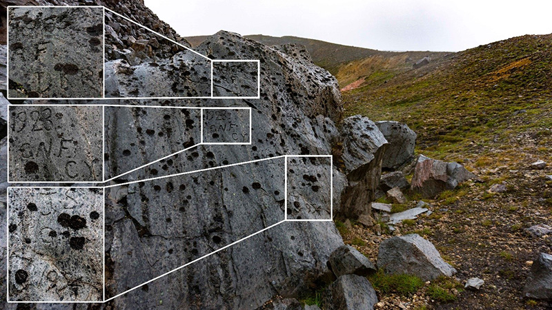
Figure 6 – Carved graffiti found on the south side of the Novarupta volcano lava plug. The initials and dates (1923/1953/1954/1955) indicate that these carvings were made by research teams from Carnegie Institute and the Katmai Project Photo by Laura Stelson.
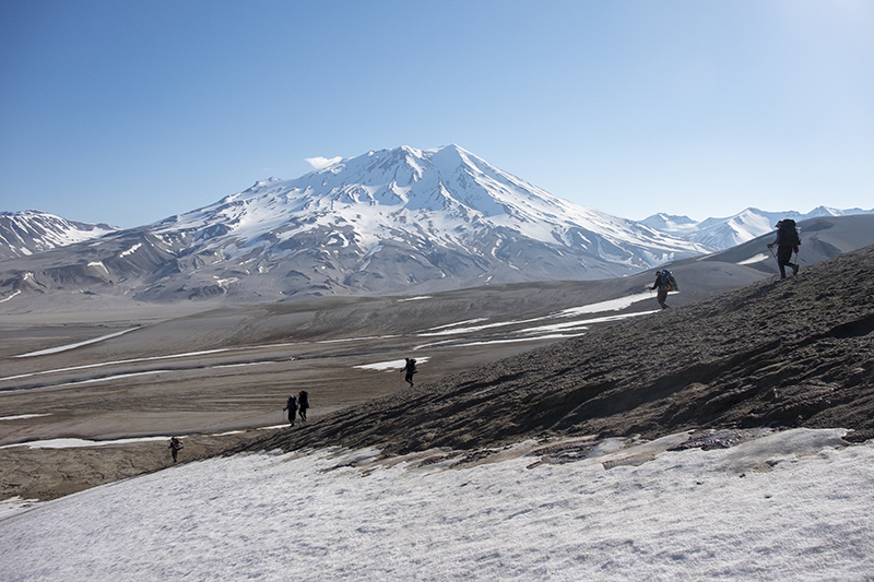
Figure 7 – Backpackers descend into the Valley of 10,000 Smokes from Baked Mountain. Photo by Mark Melham.
Whether the new knowledge and significance of these unusual remnants of historic scientific activity will spark a greater visitor appreciation of and access to these resources, remains to be seen. While access to Katmai remains fairly difficult compared to other large wilderness areas in Alaska (e.g., Denali; Wrangell-St. Elias), the potential for increased use, and associated risks to the wilderness and cultural resources is always of concern. Given the discoveries of this examination, the growing popularity of long-distance hiking, the relative easy travel on much of the Katmai Pass Route (i.e., approximately 40 miles of flat, accessible terrain), and the ever-increasing effect of social media on visitor use trends (Donahue et al. 2018; Miller et al. 2019), these numbers could increase. Finally, we would be remiss not to acknowledge the potential unintended consequences associated with this National Geographic-sponsored expedition. For example, the expedition’s findings could induce increased visitation, and therefore associated need for more direct and indirect management along the Katmai Pass Route, and Katmai as a whole. Continued monitoring and future research are merited, to document the media presence and dissemination of the expedition’s findings, and potential correlations with use increases as well as resource conditions. In a landscape defined by rapid change, these possibilities are difficult to discount.
About the Authors
LAURA STELSON is an archaeologist and Ph.D. candidate at the Pennsylvania State University, Department of Anthropology and Human Dimensions of Natural Resources and the Environment Program; email: lfs20@psu.edu
WILLIAM L. RICE is an assistant professor at University of Montana, Parks, Tourism and Recreation Management Program; email: will.rice@mso.umt.edu
DERRICK TAFF is an assistant professor at the Pennsylvania State University, Department of Recreation, Park and Tourism Management; email: bdt3@psu.edu
References
Cahalane, V. 1959. Biological survey of Katmai National Monument. Smithsonian Miscellaneous Collections 138. Washington D.C.: The Smithsonian Insititution
Clemens, J., & F. B. Norris. 2008. Building in an ashen land: Katmai National Park and Preserve historic resource study. Anchorage: National Park Service.
Cowley, J., P. Landres, M. Memory, D. Scott, & A. Lindholm. 2012. Integrating cultural resources and wilderness character. Park Science 28(3): 29–33.
Death Valley National Park. 2012. Death Valley National Park Wilderness and backcountry stewardship plan and environmental assessment. Death Valley, CA: National Park Service.
DeSantis, M. K. 2020. The federal role in historic preservation: An overview. Washington, DC: Congressional Research Service.
Donahue, M. L., B. L. Keeler, S. A. Wood, D. M. Fisher, Z. A. Hamstead, & T. McPhearson. 2018. Using social media to understand drivers of urban park visitation in Twin Cities, MN. Landscape and Urban Planning 175: 1-10.
Dumond, D. E. 2011. Archaeology on the Alaska Peninsula: the northern section, fifty years onward. University of Oregon anthropological papers (Vol. 70). Eugene, OR: University of Oregon.
Fay, G., & N. Chistensen. 2012. Katmai National Park and Preserve economic significance analysis and model documentation. In S. Weber (Ed.), Rethinking protected areas in a changing world: Proceedings of the 2011 George Wright Society biennial conference on parks, protected areas, and cultural sites (pp. 93–98). Hancock, MI: The George Wright Society.
Gourley, S. R. 2017. Towards ethical stewardship: Balancing natural and historic cultural resources in national parks. Virginia Environmental Law Journal 35: 522–565.
Griggs, R. F. 1917. The explorations of the National Geographic Society in the Katmai District of Alaska. National Geographic Magazine 31(1): 12–68.
Griggs, R. F. 1918. The Valley of Ten Thousand Smokes: An account of the discovery and exploration of the most wonderful volcanic region in the world. National Geographic Magazine 33(2): 115–169.
Griggs, R. F. 1921. Our greatest National Monument: The National Geographic Society completes its explorations in the Valley of Ten Thousand Smokes. National Geographic Magazine 40(3): 219–292.
Griggs, R. F. 1922. The Valley of Ten Thousand Smokes. Washington D.C: National Geographic Society.
Hildreth, W., & J. Fierstein. 2012. The Novarupta-Katmai Eruption of 1912—Largest eruption of the twentieth century: Centennial perspectives professional paper 1791. U.S. Geological Survey Professional Paper 1791. U.S. Geological Survey.
Huddart, D., & T. Stott. 2020. Adventure tourism in Alaska. In Adventure Tourism (pp. 184–240). London: Palgrave Macmillan. https://doi.org/10.1007/978-3-030-18623-4
King. T. F. 2008. Saving places that matter: A citizen’s guide to the National Historic Preservation Act. New York: Routledge.
Kirn, L. A. 2013. A case for storied landscapes: Wilderness and historic preservation (Master’s thesis). Goucher College, Towson, MD.
Landres, P. 2017. Balancing the Benefits and Impacts of Science in Alaska’s Wilderness. Alaska Park Science Series: The Legacy of ANILCA, 4(2). Retrieved from https://www.nps.gov/articles/aps-v4-i2-c16.htm
Landres, P., C. Barns, S. Boutcher, T. Devine, P. Dratch, A. Lindholm, A., … R. Mountain. 2015. Keeping It Wild 2 Character Across the National Wilderness Preservation System, (RMRS-GTR-340), 114.
Lipe, W. D. 2009. Archaeological values and resource management. In L. Sebatian & W. D. Lipe (Eds.), Archaeology & Cultural Resource Management: Visions for the future (pp. 41–64). Santa Fe, NM: School for Advanced Research Press.
Lum, C. S., S. J. Keith, & D. Scott. 2019) The long-distance hiking social world along the Pacific Crest Trail. Journal of Leisure Research 51(2): 165-182.
Miller, Z., B. D. Taff, P. Newman, P & B. Lawhon. 2019. A proposed research agenda on social media’s role in visitor use and experience in parks and protected areas. Journal of Park and Recreation Administration 37(3): 134-142.
Morris, D. K., & Q. B. Evison. 1986. General management plan, Wilderness suitability review and land protection plan. U.S. Department of the Interior, National Park Service.
Nagle, J. C. 2014. Wilderness exceptions. Environmental Law 44: 373–414.
National Park Service. 1988. National register of historic places. Washington, DC: U.S. Department of the Interior, National Park Service, National Register of Historic Places.
National Park Service. 1998. NPS-28: Cultural Resource Management Guideline.
Norris, F. B. 1996. Isolated paradise: An administrative history of the Katmai and Aniakchak National Park units, Alaska. Anchorage, AK: National Park Service, Alaska Regional Office.
Norris, F. B. 2004. Tourism in Katmai Country: A History of Concessions Activity in Katmai National Park and Preserve. Anchorage, AK: National Park Service, Alaska Regional Office.
Norris, F. B. 2006. Crown Jewel of the North: An Administrative History of Denali National Park and Preserve, Volume 1 – General Park History to 1980 Produced. Anchorage, AK: National Park Service, Alaska Regional Office.
Palumbo, G. 2002. Threats and Challenges to the Archaeological Heritage in the Mediterranean. In J. M. Teutonico & G. Palumbo (Eds.), Management Planning for Archaeological Sites (pp. 3–12). Los Angeles, CA: The Getty Conservation Institute. https://doi.org/10.2307/4129643Park, L. O., Manning, R. E., Marion, J. L., Lawson, S. R., & Jacobi, C. (2008). Managing Visitor Impacts in Parks: A Multi-Method Study of the Effectiveness of Alternative Management Practices. Journal of Park and Recreation Administration , 26(1), 97–121.
Rice, W. L., Z. D. Miller, P. Newman, B. D. Taff, & K. Y. Zipp. 2019. Recreation impacts of road noise in Death Valley National Park: 2018 visitor study. Death Valley, CA: National Park Service, Natural Sounds and Night Skies Division.
Ringsmuth, K. 2013. At the heart of Katmai: an administrative history of the Brooks River Area, with special emphasis on bear management in Katmai National Park and Preserve 1912-2006. Washington D.C: U.S. Department of the Interior, Government Printing Office.
Sebatian, L. 2009. Deciding what matters: Archaeology, eligibility and significance. In L. Sebastian & W. D. Lipe (Eds.), Archaeology & cultural resource management: Visions for the future. Santa Fe, N.M.: School for Advanced Research Press.
Ross, M. N. 2013. The requirement to leave park resources and values “unimpaired.” The George Wright Forum 30(1): 67–84.
Ryan, J. S. 1999. Preventing cultural resources destruction: taking action through interpretation. Washington, D.C. Retrieved from http://hdl.handle.net/2027/umn.31951p009092940
Shaffer, D. 2016. Connecting humans and nature: The Appalachian Trail landscape conservation initiative. George Wright Forum 33(2): 175–184.
Sellars, R. W. 2007. A very large array: Early federal historic preservation – The Antiquities Act, Mesa Verde, and the National Park Service Act. Natural Resources Journal 47(2): 267–328.
Sheldon, K. M. 2019. Going the distance on the Pacific Crest Trail: The vital role of identified motivation. Motivation Science. Advance online publication.
Stelson, L., & J. Walton. 2019. Archaeological and botanical findings of the project “Following in the footsteps of the National Geographic Society’s original Katmai Expeditions. King Salmon, AK: National Park Service, Katmai National Park and Preserve.
Strawn, M., & Y. Le. 2014. Katmai National Park and Preserve Visitor Study. Pullman, WA: Washington State University.
Watt, L. A. 2002. The trouble with preservation, or, getting back to the wrong term for Wilderness protection: A case study at Point Reyes National Seashore. Yearbook of the Association of Pacific Coast Geographers 64: 55–72.
Wildesen, L. E. 1982. The Study of Impacts on Archaeological Sites. Advances in Archaeological Method and Theory 5(1982): 51–96. https://doi.org/10.1016/b978-0-12-003105-4.50007-8
Yin, R. K. 2003. Case study research: Design and methods (3rd ed.). Thousand Oaks, CA: Sage.
Yun, J. & J. G. Peden. 2018. Situational influences on experiences of long-distance hikers. Journal of Outdoor Recreation, Education and Leadership 10(3): 45, 226-237.
Read Next
Foundation and Future of Long Distance Trails
We begin this special edition of the International Journal of Wilderness with references to the U.S. Wilderness and National Trails System Acts to illustrate the significance and interconnectedness of wilderness areas and long-distance trails.
With Collaboration We Can Overcome Challenges Together
The concepts of “shared stewardship” or “collaborative management” can be challenging. They require shared vision, definition of clear roles and responsibilities, and commitment to the collaborative process.
Shared Stewardship and National Scenic Trails: Building on a Legacy of Partnerships
National Scenic Trails connect people with the natural and cultural heritage of the United States. Theses trails also provide important opportunities for agencies to engage partners in trail stewardship and sponsorship.