© Jayme Dittmar
Applying Recreation Ecology Science to Sustainably Manage Camping Impacts: A Classification of Camping Management Strategies
Communication & Education
August 2018 | Volume 24, Number 2
PEER REVIEWED
Wilderness and other protected natural areas such as national forests, parks, and refuges are managed to provide high-quality recreational opportunities while preserving natural resource conditions. In managing recreation visitation, land managers could allow visitors to create their own infrastructure of trails and campsites, or they could choose to apply an impact management strategy to provide an infrastructure that includes sustainably designed trails and campsites. Recreation ecology studies have repeatedly demonstrated that informal “visitor-created” trails and campsites are generally not sustainably designed or located (Cole 1981, 1982a, 2013; Marion 2016; Wimpey and Marion 2011). For example, informal trails frequently occur in flat terrain where trail widening and muddiness can be chronic problems, or are fall-aligned (perpendicular to contour lines) in sloping terrain, where they are considerably more vulnerable to soil loss and widening (Marion et al. 2016; Marion and Wimpey 2017). Similarly, visitors are highly attracted to flat terrain near water for camping, where they frequently create substantial numbers of large and unnecessary campsites at densities that threaten visitor solitude, experiential qualities, and natural resources.
Although wilderness managers have commonly adopted a professional approach to trail management that emphasizes sustainably designed, constructed, and managed formal trail systems, studies do not reveal a similar strategy applied to camping management (Cole 1982a 1982b, 2013; Leung and Marion 2000, 2004). Based on a review of the literature, this article describes the consequences of largely unconfined “dispersed” camping that emphasizes visitor-selected and -created campsites at locations of their choosing, with limited additional guidance. We present and describe a simple classification system of camping management strategies and options and urge managers to consider adopting a more proactive and sustainable camping “containment” strategy that emphasizes using a reduced subset of management-selected and -created campsites based on evaluations of their resource and social sustainability.
Next, we examine the “wilderness character” trade-offs associated with trail and camping infrastructure decision-making and suggest that the clear benefits for having an infrastructure of formal trails are the same for having an infrastructure of sustainable campsites, as part of a camping impact containment strategy. Finally, we examine several recreation ecology research studies that demonstrate how a combination of management strategies and actions have been applied to significantly reduce aggregate camping impact and promote high-quality social conditions.
Camping Management Strategies
Protected area managers have a diverse array of strategies and actions in their management “toolbox” for achieving resource protection and visitor management objectives (Cole et al. 1987, 1997; Leung and Marion 1999, 2004; Marion 2016). Related to camping, managers commonly seek to achieve the following core objectives: limit campsite numbers and the aggregate areal extent and severity or resource impact, promote high-quality social conditions, and preserve visitor freedom to camp in desirable locations. We further suggest that a key measure of agency success in achieving resource protection objectives is to minimize the aggregate area of camping impact by minimizing both campsite numbers and sizes.
Although land managers have commonly applied some form of unconfined or largely unregulated camping (Cole 1993), recreation ecology research has revealed the greater merits of two core camping impact management strategies, dispersal and containment, derived from an improved understanding of the relationship between amount of use and resource impact (Marion 2016). Experimental trampling and camping studies have consistently demonstrated that most biophysical changes occur with initial and low levels of use, generally fewer than 15 nights/year over the first two to three years (Figure 1) (Cole 1982b; Cole and Monz 2003; Marion 2016). Above this level, per capita impacts diminish substantially, and campsite conditions stabilize, achieving a relatively constant equilibrium over time (Cole 2013; Marion and Cole 1996). Even doubling use on a well-established campsite only marginally increases measurable resource impacts, particularly for sustainably selected campsites that resist site expansion.
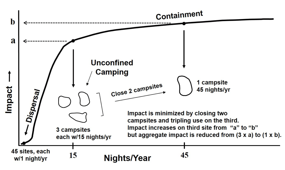
Figure 1 – A generalized model of the use-impact relationship for camping on vegetation and soil illustrating the empirical basis for effective dispersal and containment strategies. In this example, aggregate impact under many unconfined camping policies, three times an “a” level of impact, is substantially reduced under a Containment strategy that closes two campsites and shifts their use to a single site with a “b” level of impact. Alternatively, if camping could be fully dispersed to 45 sites used only once a year (and/or to highly resistant substrates), no lasting impact would occur (from Marion 2016).
This asymptotic relationship between camping use and resource impact has significant implications for devising effective camping impact management strategies (Figure 1). A clear implication is that managers can employ a Dispersal Strategy to avoid resource impacts by reducing use to levels that prevent impacts lasting more than a year. Alternatively, managers can employ a Containment Strategy to minimize aggregate camping impact by concentrating use on a limited subset of more heavily used sites (Leung and Marion 1999; Marion 2016). These two preferred strategies are featured in the following classification of Camping Strategies, along with unconfined camping (Table 1).
Unconfined
For more than four decades US federal land managers have favored a largely unregulated camping strategy that promotes visitor freedom to select and create campsites in locations of their choosing, with limited additional guidance (Cole 1993, 2013). Managers typically refer to this strategy as “dispersed camping,” although it can encompass a range of policies that may not seek to disperse or reduce site use. In practice, many managers who employ dispersed camping urge visitors to select well-established campsites and/or apply educational guidance or regulations to shift campsites away from waterbodies, and more rarely from formal trails or popular destination areas. Some managers have additionally sought to close and restore campsites that are unnecessary; too close to water, trails, or other campsites; or are considered less sustainable – when combined with a request to camp on established campsites this scenario is like the established site camping strategy described below. We note that the “dispersed camping” nomenclature is not the same as that conveyed in Figure 1, where dispersal explicitly refers to the reduction of use to levels that avoid lasting resource impact. For clarification in this article we refer to dispersed camping as an “unconfined” camping strategy because visitors, not managers, are mostly free to select or create campsites, generally without knowledge or consideration of sustainability attributes that promote the protection of resource and social conditions. This and other camping strategies can be applied to entire wilderness areas or to specific zones.
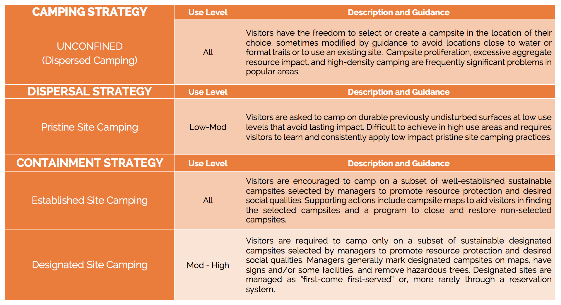
Table 1 – Camping management strategies, options, and guidance.
Dispersal Strategy
A strictly defined dispersal strategy is Pristine site camping, where visitors are asked to: (1) locate an area out of sight or distant from trails, water, and campsites with no evidence of visitor trampling or camping and trampling-resistant surfaces that show little evidence of camping impact; (2) camp one to several nights, concentrating use on the most resistant surfaces and departing before lasting impact is created; and (3) restore and naturalize the site to mask visible impacts and deter future campers from finding and reusing it. Trampling-resistant surfaces include durable rock, gravel, or snow; areas with little to no vegetation (e.g., shady forests, sandy shorelines, dry washes); or dry, grassy areas (Marion 2014). Cole and Benedict (1983) and Marion (2014) describe this form of camping, cautioning that visitors must apply these low impact practices to avoid the creation of new campsites. Though this form of camping is permitted in many protected areas, few managers have encouraged this practice, perhaps because when ineffectively applied it can lead to campsite proliferation (Marion 2016).
Containment Strategy
Recreation ecology studies support a containment strategy as the most effective option in moderate to high-use settings, with visitors encouraged to use a limited number of carefully selected Established sites that meet agency guidance, or with visitors required to use only Designated sites (Cole 2013; Marion 2016; Reid and Marion 2004). As use is to be concentrated on a subset of highly visited campsites under this strategy, a key component for successful implementation is that managers carefully select campsites that are sustainable to promote the protection of both natural resource and social conditions. We define a sustainable campsite as one that can accommodate the intended type and amount of use over time without unacceptable levels of expansion, degradation, maintenance, and social crowding or conflict.
Supporting Actions from the Management Toolbox
In addition to implementing a camping management strategy, agency staff can rely on a variety of tools, or actions, from the “management toolbox” (Cole et al. 1987; Marion 2016). When choosing tools, managers should consider the potential impacts of management actions on visitor freedom, access, and the quality of their experiences. These tools may be grouped as regulatory, educational, and site management actions that range along a management continuum from less to highly intensive.
Problems in Paradise: The Chronic Failures of Unconfined Camping
Particularly in wilderness, many managers have preferred some form of an unconfined (dispersed) camping strategy that allows visitors the freedom to find and select a campsite of their choice, with minimal regulatory interference. One common regulation that managers have applied has been to prohibit camping within various specified distances of waterbodies, as described in another article in this issue (Marion et al. 2018). Recreation ecologists who study the impacts of visitor use in protected areas have consistently documented some substantial avoidable and unacceptable natural resource and experiential impacts associated with unconfined camping policies (Cole 1982a 1982b, 2013; Leung and Marion 2000, 2004). Three common/chronic problems include (1) visitors frequently create nonsustainable campsites in flat terrain close to popular attraction features or destination locations, water, and formal trails; (2) visitors create high-density clusters of large campsites with unacceptable levels of resource and social impact in the most popular areas; and (3) site proliferation over time leads to exceptionally large numbers of unnecessary campsites. These topics are examined and illustrated below with data from campsite monitoring surveys and research in various US regions.
In 1999, the Appalachian Trail management community sought to identify the worst camping locations trailwide, and initiate consulting and management actions to resolve resource and social impacts (Marion 2003). Seventeen locations in eight states were identified and visited by an interdisciplinary team of land managers, volunteers, and scientists. Annapolis Rocks, a scenic overlook and popular camping spot in Maryland, was judged to be the “worst” location in 1999. It had been managed under an unconfined (dispersed) camping policy that permitted visitors to create a large cluster of 19 campsites in flat terrain adjacent to the vista, with exceptionally high levels of resource and social impacts (Figure 2). Mean campsite size was 2,271 feet2 (211 m2), including three mega-sites exceeding 5,000 feet2 (464.5 m2) formed by the expansion and merging of several proximate sites (Daniels and Marion 2006). The aggregate area of camping impact was 43,099 feet2 (4,004 m2), including 23,116 feet2 (2147 m2) of exposed soil, 83 damaged trees, and 137 tree stumps. A questionnaire examined visitor satisfaction with camping in the area using a scale of 1 (highly dissatisfied) to 5 (highly satisfied) to evaluate 22 utility, environmental, and social indicators. The indicators with the four lowest scores were “privacy of my campsite” (3.26), “noise from other groups” (3.27), “amount of bare soil” (3.27), and “number of people camped near me” (3.31) (Daniels and Marion 2006).

Figure 2 – One of three “mega-sites” within a cluster of 19 campsites at Annapolis Rocks, Maryland, identified by the Appalachian Trail management community in 1999 as its “worst” example of resource and social camping impacts. This location illustrates the chronic problems that an unconfined camping policy allows: excessive site proliferation and campsite expansion occurring in large flat areas that create unacceptable resource and social conditions.
The problems of unconfined camping were also evident in a survey of 11 US Forest Service wilderness areas in Virginia. Leung and Marion (2000) found that a large majority of campsites (72%) created by visitors were located along and within sight of formal trails, with 38% fewer than 25 feet (7.62 m) from formal trails. Campsites were unevenly distributed, with visitors creating high densities of campsites in large flat areas close to camping shelters and streams. Results suggest that visitors rarely select campsite locations based on a desire for solitude or privacy, and their proximity to trails and camping shelters reduces the potential for solitude of other hikers and campers. Neither were these campsites in resistant locations; most were located under forest canopies on fragile forest herbs in flat terrain where site expansion and proliferation have and will always be chronic problems (Leung and Marion 2000).
Virginia’s Shenandoah National Park (NP) wilderness managers applied a modified unconfined camping policy beginning in 1974 that actively sought to shift visitors away from trails and water by prohibiting camping within 25 feet of water and within sight of formal trails (Williams and Marion 1995). However, a comprehensive census survey in 1992–1993 found that 68% of all sites (n=725) were in violation of these polices, including 25% located fewer than 25 feet from water and 56% within sight of formal trails (58% were <150 ft. from trails). Based on permit data, managers estimated that campsite visitation ranged from 0 to 50 nights/year, with most sites receiving 5 to 20 nights/year. Scientists and managers who examined the survey findings and permit data concluded that there were large numbers of campsites receiving low levels of use that, if eliminated, would substantially reduce aggregate camping impact (Williams and Marion 1995).
Recreation ecology studies in the western states report similar findings to these eastern examples. In a study of wilderness campsites in Oregon’s Eagle Cap Wilderness, Cole (1982a) found that most campsites were concentrated at just a few popular destinations. Within two popular lake basins permit data suggest that about 10 groups/night camped on 221 campsites during the core part of the use season, an occupancy rate of only 4.5%. The unconfined camping policy had allowed excessive campsite proliferation to occur, most of which were “within a few hundred feet of water sources and within sight of a trail.” Cole’s recommendation was to reduce aggregate camping disturbance by concentrating use on “only a small proportion of the sites,” noting that their research also found that “the most frequently used sites were not disturbed much more than sites used no more than once a week” (Cole 1982b). A later study reported that the number of campsites at the 7 high-use lakes increased by 134% over 15 years, with campsite density in 1990 exceeding two sites per hectare and “many clusters of sites so dense that it is difficult to tell where one site ends, and another begins” (Cole 1993).
In a similar study of Montana’s Lee Metcalf Wilderness Cole (1993) documented campsite proliferation that increased site numbers 84% from 1972 to 1988, which he attributed to “an increase in site-pioneering behaviors” and “passive campsite management programs.” He concluded that “campsite proliferation is a highly significant problem that demands more attention from wilderness managers.” The authors noted that reducing use levels at popular destination areas “would likely have more negative than positive consequences,” and that “neither encounter levels nor physical impacts would be reduced to any meaningful extent.” The authors concluded that (1) the primary physical impact problem associated with camping is the large aggregate areal extent of camping impact, which is largely linked to campsite proliferation; (2) education by itself is insufficient to concentrate use; and (3) that direct management in the form of an intensive program of site management is needed to shift use to a subset of existing campsites (Cole et al. 1997).
Although unconfined camping policies allow visitors the ability to select and create preferred campsites, that freedom comes with a significant cost related to the creation of large numbers of unsustainable campsites in flat terrain near water and trails. It also reveals that use reduction is a poor tool for constraining campsite proliferation, aggregate camping impact, and crowding/conflict concerns, particularly in higher use areas (Cole et al. 1997). Neither have assisting direct actions such as camping setbacks or indirect actions such as education been very successful. Our review demonstrates that in popular high-use areas managers frequently experience chronic problems with dense clustering of campsites near trails and water that threaten visitor solitude and social conditions, and that site proliferation can also be a problem in low- and moderate-use areas.
Implementing a Containment Strategy
The dispersal and containment campsite impact management strategies (Figure 1 and Table 1) are directly derived from recreation ecology experimental trampling and camping studies and empirical research on campsites (Cole 1995a, 1995b; Marion 2016; Marion and Farrell 2002; Reid and Marion 2004). These studies also provided the basis for the national Leave No Trace program’s guidance to concentrate use on campsites in popular areas while dispersing use in remote or low-use areas (www.LNT.org; Marion 2014). For example, Cole (1982a) suggests camping dispersal on sedge meadows in the Eagle Cap Wilderness can be tolerated several nights/year if campfires are not constructed. However, his core recommendation was a containment strategy, to reduce aggregate camping disturbance by encouraging visitors to use a subset of the existing campsites.
Established campsites can be marked or unmarked on the ground, they typically have few or no facilities, and they are generally more numerous and offer greater visitor choice than designated campsites, which are marked and may have greater infrastructure development, such as anchored steel fire rings, primitive toilets, or food storage facilities. Because visitors are required to use designated campsites a management agency generally assumes greater responsibility for periodically surveying for and removing hazardous trees. Under established site camping visitors are encouraged to use management-selected sustainable campsites but retain the freedom to camp elsewhere so agency liability for hazardous trees is reduced (however, we note that some managers have “required” the use of established campsites). The smaller sizes of sustainable designated and established sites make it easier for agency staff to manage hazard trees, and agency control over campsite locations allows for shifting them to more open settings with fewer trees and more trampling-resistant grassy ground vegetation. Designated site camping is typically necessary only in the most popular and intensively visited areas. In some of these areas, managers additionally operate rationing or reservation systems that restrict the number of groups to the number of designated sites, or even assign groups to specific sites by date.
Several studies reveal that shifting camping to locations in sloping terrain is the most important sustainability factor in spatially concentrating camping activity on small campsites that will resist future expansion and campsite proliferation (Marion and Farrell 2002; Daniels and Marion 2006; Eagleston and Marion 2017). Other sustainability factors include durable surfaces such as rock, barren trampling-resistant substrates such as gravelly or sandy shorelines, dense shade that supports little vegetative ground cover, sunny locations with grassy vegetation, and extreme rockiness in off-site areas (Marion 2016). A 32-year study by Eagleston and Marion (2017) discovered that selecting campsites in dense woody vegetation is only temporarily effective in deterring site expansion, as woody vegetation is removed over time by insects, disease, fires, or felled by visitors for firewood.
Current studies by the authors on the Appalachian and Pacific Crest Trails (AT and PCT) is focused on the development, testing, and refinement of protocols for evaluating the sustainability of existing or new sites with ground- and computer-based Geographic Information System (GIS) assessments. The objective of this research is to identify sustainability criteria and develop GIS methods that can be efficiently applied to large numbers of agency backcountry and wilderness campsites. Unfortunately, GIS methods will require accurate Global Positioning System (GPS) campsite locations and high-resolution topographic data (e.g., aerial LiDAR derived DEMs) that are not yet available for many areas.
Preferred designated or established campsites can be identified through a careful selection process that emphasizes the selection of the most sustainable existing campsites and, over time, the creation and use of new, highly sustainable locations identified by managerial actions. Campsites that are not sustainable, are unnecessary, or are too close to water, cultural/historic sites or threaten wildlife, rare species, or sensitive habitats can be omitted and closed for restoration. Inclusion of social criteria such as campsite amenities, scenic beauty, and proximity to trails, other sites, or day-use areas such as vistas can also be incorporated to promote high-quality social conditions and visitor satisfaction (Daniels and Marion 2006). An important consideration is matching the availability of established or designated campsites to campsite demand within travel zones.
An essential element of the containment strategy is for managers to restrict camping to a small subset of campsites. For example, National Park Service managers at Delaware Water Gap National Recreation Area substantially improved their designated site policy for backcountry riverside campsites in 1988 by reducing campsite numbers and installing anchored steel fire rings to specifically identify each legal campsite location (Marion 1995). Limited river patrols and enforcement efforts improved designated site camping compliance while closed and illegal campsites were left to recover naturally. A comparison of monitoring data from 1986 to 1991 revealed a reduction from 179 campsites (116 designated and 63 illegal) to 110 campsites (87 designated and 23 illegal). Even though designated campsite use levels increased 28%, from 268 to 344 campers/site/year, the aggregate area of camping impact for all sites decreased 50%, from 302,896 feet2 (28,140 m2) to 150,910 feet2 (14, 020 m2). River rangers reported that campsite demand exceeded supply typically on only two peak use weekends each year.
A study by Reid and Marion (2004) evaluated actions at Shenandoah NP to convert an ineffective unconfined camping strategy to an established site camping strategy by asking visitors to only use “well-established” campsites. They also sought to close unnecessary and less sustainable campsites, assessed as sites with a higher potential for expansion potential based on topography, rockiness, and dense woody vegetation. Efforts were also made to increase the spacing of the selected sites from water, trails, and other selected sites to further protect resource and social conditions. Park staff performed limited restoration work once a year on the “closed” campsites, consisting of fire ring removal and placement of leaves, brush, and/or logs on barren areas to deter camping. Over three years, campsite numbers were reduced by 49%, aggregate campsite area by 50%, and area of vegetation loss by 44%. Campsite occupancy rates increased from approximately 19 to 29 nights/year on the remaining sites, but their mean size increased only 3%. We note that visitors frequently failed to find and use established campsites located out of sight from trails, so providing visitors with maps or GPS coordinates that identify campsite locations may be necessary.
Established site camping has also been implemented successfully in other wilderness areas when managers have implemented aggressive programs that target the closure and restoration of larger numbers of unnecessary, illegal, or nonsustainable campsites. For example, although not called established site camping, Cole and Ferguson (2009) describe how an active program of campsite closure and restoration in the Caney Creek Wilderness of Arkansas successfully reduced campsite numbers 40%, from 91 in 1994 to 54 in 2007. The largest decrease was in the number of highly impacted campsites, with median campsite size reduced from 2,500 ft2 (232 m2) to 915 ft2 (85 m2). Of note was the closure and relocation of a riparian corridor trail containing some of the most unacceptable camping impacts. Following the trail closure the old campsites were no longer accessed by visitors. Even greater success was achieved in Sequoia and Kings Canyon National Parks where visitors are directed to camp on “previously impacted areas.” An intensive program of campsite closure and restoration was primarily responsible for a more than two-thirds reduction in aggregate camping impact from the late 1970s to 2007 (Cole and Parsons 2013). Park staff obliterated large numbers of unnecessary campsites in areas of high site densities and where campsites were close to water and removed fire rings in areas where campfires were prohibited.
We stress that the efficacy of established site camping is improved when campsites are identified on maps and GPS coordinates and when managers can sustain efforts to actively close and restore nonselected campsites. We also suggest placing large flat “kitchen rocks” on established sites to attract and spatially concentrate intensive cooking activities to a single fixed location, and/or if campfires are permitted, ice-berging a few large rectangular rocks around a preferred campfire location (Figure 4) (Reid and Marion 2005).
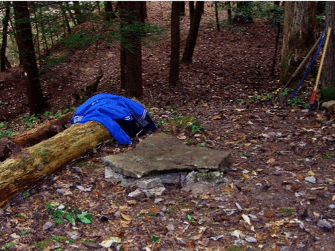

Figure 3 – Minimal site facilities such as a large flat “kitchen rock” for stove use (left) or a small fire ring of large ice-berged rocks (right) can serve to identify, attract, and spatially concentrate camping activity on established campsites.
Side-Hill Campsites
Based on research at Isle Royale National Park, Marion and Farrell (2002) suggested that aggregate camping impact can be most effectively minimized by promoting camping on constructed “side-hill” campsites in sloping terrain (>20% slope), where the topography naturally inhibits campsite expansion and proliferation (Figure 4). This practice had been applied to create many of Isle Royale’s campsites, achieving a very high level of camping activity concentration and constraining mean campsite size to 645 ft2 (60 m2), representing the lowest mean area of camping disturbance per overnight stay documented in the existing literature (Marion and Farrell 2002). Side-hill campsites can be located to enhance social qualities, and their small size and ability to provide pristine conditions in adjacent areas are also aesthetically pleasing to visitors.
Constructed side-hill campsites were recommended at numerous locations along the AT in 2003 as part of a larger campsite consulting study (Marion 2003), including as designated or established campsites. At Annapolis Rocks in Maryland side-hill campsites were constructed to resolve the substantial and unacceptable camping impacts there (Figure 2). The 19 visitor-created campsites that had resulted from unconfined camping were replaced in 2003 by 14 designated side-hill constructed campsites in sloping terrain just uphill from the former sites. The new campsites were distributed above and below a side-hill trail at locations to enhance the potential for solitude. The aggregate area of camping impact was reduced from 43,099 ft2 (4,004 m2) to 6,243 ft2 (580 m2) after 1 year and to 8,574 ft2 (796 m2) after 9 years (Daniels and Marion 2006). A questionnaire examined visitor satisfaction with camping on the side-hill campsites using a scale of 1 (highly dissatisfied) to 5 (highly satisfied) to evaluate 22 utility, environmental, and social indicators. The indicator that had scored lowest for the clustered visitor-created campsites, “privacy of my campsite” (3.26), became the highest score for visitors camping on the new side-hill campsites (4.30). The next three highest indicators were “number of people camped near me” (4.23), “security of my belongings at my campsite” (4.23), “noise from other groups” (4.21), and “naturalness of the area near my campsite” (4.18) (Daniels and Marion 2006).
Current AT and PCT studies by the authors are investigating efficient ground- and GIS-based methods for identifying optimal locations both for constructing side-hill campsites and for locating “naturally occurring” side-hill campsites (Figure 5). More than 800 side-hill campsites have been created along the AT since 2002, and they have proven to be highly sustainable and effective in reducing both resource and social/experiential camping impacts (Marion 2016). A significant advantage of side-hill campsites is that visitors spatially concentrate their camping activities to campsites with a small footprint through natural interactions with surrounding topography rather than in response to regulations and enforcement or their ethical knowledge and conscience (Marion and Farrell 2002). Shifting camping to constructed or naturally occurring side-hill sites resolves the chronic management problems of campsite expansion and proliferation that have proven to be inevitable in flat terrain. The extremely small size of these sites also makes it substantially easier for agency staff to manage hazardous trees.
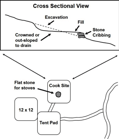
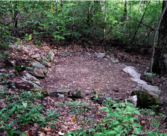
Figure 4 – Highly sustainable “side-hill” campsites can be constructed in sloping terrain to spatially concentrate camping activity on exceptionally small campsites. This site (right) was constructed along the AT at Annapolis Rocks, Maryland, and visitors expressed strong support and satisfaction with their creation (Daniels and Marion, 2006; figure from Marion 2016).
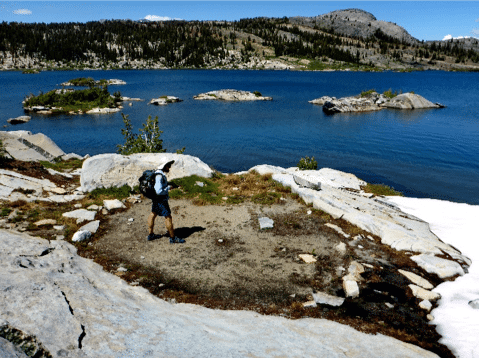
Figure 5 – Current research on campsite sustainability along the Pacific Crest Trail identified these highly sustainable naturally occurring “side-hill” campsites located in the Inyo National Forest at Thousand Island Lake, where surrounding topography and rockiness effectively inhibits site expansion and proliferation.
Wilderness Character Considerations
An examination of wilderness character concerns (Landres et al. 2015) reveals both benefits and costs associated with the provision of an infrastructure of sustainably selected campsites managed under a containment strategy. Research reveals that the successful application of this strategy can avoid or substantially reduce resource and social impacts from those occurring under an unconfined management strategy, particularly in high-use settings. The reduced campsite numbers and impacts would improve the natural conditions of wilderness, a core quality of wilderness character. A second quality, solitude or a primitive and unconfined type of recreation, is improved by separating campsites from trails and other sites, but designated site camping would restrict visitor freedom to camp anywhere. The reduction in campsite numbers would improve the undeveloped character of wilderness, but any facilities provided on designated sites would detract. The fourth core quality of wilderness character, untrammeled, is somewhat compromised by the required use of designated sites. Finally, other features of value are preserved when campsites are more sustainably selected and located to avoid degrading sensitive archaeological, historical, or paleontological sites.
In our evaluation the potential threats to wilderness character associated with formal trail systems that employ side-hill constructed treads, stone staircases, engineered drainage features, and treated dimensional lumber or steel in bridges greatly exceed those related to the use of designated site camping in high-use areas. We presume that wilderness managers have evaluated wilderness character qualities and trade-offs for developed trail infrastructures and justified their need. While the “rewilding” movement has sought to restore native flora and fauna in protected areas, and even to remove and restore unnecessary roads (Switalski et al. 2004), managers have continued to construct and maintain formal trail networks in wilderness. An important question raised in this article is why we have not found the same logic and decision-making to the professional management of trails applied to wilderness campsites, and why we less commonly have developed infrastructures of sustainable wilderness campsites.
Challenges and Research Needs
We suggest that additional studies be focused on evaluating and improving the implementation of the pristine site camping strategy in low-use areas and the containment strategy in moderate- to high-use areas. An important remaining challenge for implementing established site camping is developing compelling and effective education, communication, and navigation aids to direct visitors to established sites and to avoid using closed/illegal sites. Campsite closure and restoration programs applied to accomplish this are staffing intensive and difficult to sustain long-term, are frequently ineffective in closing well-used campsites, and cannot direct visitors to the most sustainable sites. The success of this work can be substantially improved by identifying established and designated site locations on printed and digital maps and in GPS files posted on websites, just as formal trail networks are. For example, Voyageurs National Park provides a digital file of GPS waypoints for all their backcountry campsites. Visitors are increasingly using smartphones, and their connectivity to accurate GPS satellite networks allows a variety of phone apps to access easily updated digital maps for wildland navigation. For example, one popular phone app includes campsites and navigational aids to easily find them and welcomes collaborations with managers to substitute a listing of more sustainable sites. These new media also facilitate the communication of information on camping regulations and low-impact practices based on a user’s specific location.
Important future research could test the use of printed and digital maps to direct visitors to the most sustainable established campsites. Such maps when viewed on GPS units or phone apps can utilize “digital fences” by depicting shaded regions that clearly illustrate camping setbacks from water or formal trails. The rapidly increasing use of digital maps by backpackers and hikers on GPS units and smartphone apps offer managers an innovative, inexpensive, and accurate method to create, update, and widely distribute information about regulations, low-impact practices, and the locations of sustainable established or designated campsites. The benefits of using these new methods is contrary to the observations of some of our colleagues, who cite the expanding use of technological devices and their personal wilderness character concerns with the electronic connectedness of wildland visitors (Dustin et al. 2017). However, Harmon (2015) observed that long-distance hikers were not constantly connected and instead had punctuated moments of interaction and use of their smartphones, concluding that disconnection is less about unplugging from these devices and more about a context shift, and social reconfiguration that takes place in the wildland setting.
Recognizing that some managers may not view the use of such technological devices to be appropriate in wilderness, we suggest that: (1) device use is legal and optional, with visitors deciding whether or not to use them; (2) these platforms offer substantial advantages in effectively communicating relevant information, particularly for shifting visitors to a sustainable subset of existing campsites; and (3) not engaging via these technologies may pose an increasing risk that agency communication efforts will become less relevant. Further, we recommend additional discourse between scientists, managers, and visitors, and additional research to evaluate the potential risks and opportunities of these expanding digital technologies on wilderness character, visitor experiences, and the efficacy of visitor use management actions.
Conclusions
Recreation ecology research and management experience reveal significant problems with unconfined camping, particularly in popular moderate- to high-use areas such as riparian corridors and lake basins. We suggest that a dispersal strategy with pristine site camping can be a viable option in remote and/or low-use areas, although more research and management experimentation are needed. In moderate- to high-use settings a containment strategy with either established or designated sites can be a preferred strategy to concentrate camping on a more sustainable subset of campsites selected to promote improved resource and social conditions. Higher levels of use and impact generally require more intensive and direct visitor-management actions such as designated site camping. Constructed and naturally occurring side-hill campsites offer another option, particularly in popular high-use areas where other strategies and actions have proved ineffective.
Acknowledgments
The authors express their thanks to Beth Boyst, USFS Pacific Crest Trail program manager; Susan Fox, director, Aldo Leopold Wilderness Research Institute; and Laura Belleville, vice president, Conservation and Trail Programs, Appalachian Trail Conservancy; and to their respective organizations for their strong and continued support of our PCT and AT programs of research. We also thank Mitch Rosen for his dedicated AT and PCT field research, Yu-Fai Leung for his peer review, and Ken Straley and Ralph Swain for their helpful comments on this article.
JEFFREY L. MARION is a recreation ecologist with the US Geological Survey stationed at Virginia Tech; email: jmarion@vt.edu
JOHANNA ARREDONDO is a graduate student at Virginia Tech, Forest Resources & Environmental Conservation; email: johanna.arredondo@gmail.com
JEREMY WIMPEY is the owner of Applied Trails Research, an outdoor recreation firm that develops science-based solutions to challenging visitor use management issues; email: jeremyw@appliedtrailsresearch.com
FLETCHER MEADEMA is a graduate student at Virginia Tech, Forest Resources & Environmental Conservation; email: fmeadema@vt.edu
References
Cole, D. N. 1981. Managing ecological impacts at wilderness campsites: An evaluation of techniques. Journal of Forestry 79: 86–89.
———. 1982a. Controlling the spread of campsites at popular wilderness destinations. Journal of Soil and Water Conservation 37: 291–295.
———. 1982b. Wilderness Campsite Impacts: Effect of Amount of Use. USDA Forest Service, Res. Pap. INT-284. Ogden, UT: Intermountain Forest and Range Experiment Station.
———. 1993. Campsites in Three Western Wildernesses: Proliferation and Changes in Condition Over 12 to 16 Years. USDA Forest Service, Res. Pap. INT-463. Ogden, UT: Intermountain Research Station.
———. 1995a. Disturbance of natural vegetation by camping: Experimental applications of low-level stress. Environmental Management 19(3): 405–416.
———. 1995b. Experimental trampling of vegetation. II. Predictors resistance and resilience. Journal of Applied Ecology 32: 215–224.
———. 2013. Changing Conditions on Wilderness Campsites: Seven Case Studies of Trends Over 13 to 32 Years. USDA Forest Service, Gen. Tech. Rpt. RMRS-GTR-300. Fort Collins, CO: Rocky Mountain Research Station.
Cole, D. N., and J. Benedict. 1983. Wilderness campsite selection: What should users be told. Park Science 3(4): 5–7.
Cole, D. N., and T. E. Ferguson. 2009. A relatively nonrestrictive approach to reducing campsite impact: Caney Creek Wilderness, Arkansas. International Journal of Wilderness 15(1): 20–25.
Cole, D. N., and C. A. Monz. 2003. Impacts of camping on vegetation: Response and recovery following acute and chronic disturbance. Environmental Management 32: 693–705.
Cole, D. N., and D. J. Parsons. 2013. Campsite Impact in the Wilderness of Sequoia and Kings Canyon National Parks: Thirty Years of Change. USDI National Park Service, Nat. Res. Tech. Rpt. NPS/SEKI/NRTR – 2013/665. Fort Collins, CO.
Cole, D. N., M. E. Petersen, and R. C. Lucas. 1987. Managing Wilderness Recreation Use: Common Problems and Potential Solutions. USDA Forest Service Gen. Tech. Rpt. INT-GTR-230. Ogden, UT: Intermountain Research Station.
Cole, D. N., A. E. Watson, T. E. Hall, and D. R. Spildie. 1997. High-Use Destinations in Wilderness: Social and Biophysical Impacts, Visitor Responses, and Management Options. USDA Forest Service, Res. Pap. INT-RP-496. Ogden, UT: Intermountain Research Station.
Daniels, M. L., and J. L. Marion. 2006. Visitor evaluations of management actions at a highly impacted Appalachian Trail camping area. Environmental Management 38(6): 1006–1019.
Dustin, D., L. Beck, and J. Rose. 2017. Landscape to Techscape: Metamorphosis along the Pacific Crest Trail. International Journal of Wilderness 23(1): 25–30.
Eagleston, H., and J. L. Marion. 2017. Sustainable campsite management in protected areas: A study of long-term ecological changes on campsites in the Boundary Waters Canoe Area Wilderness, Minnesota, USA. Journal for Nature Conservation 37: 73–82.
Harmon, M. E. 2015. Computing as context: Experiences of dis/connection beyond the moment of non/use. Dissertation, Information and Computer Science, University of California, Irvine.
Landres, P., C. Barns, S. Boutcher, T. Devine, P. Dratch, A. Lindholm, L. Merigliano, N. Roeper, and E. Simpson. 2015. Keeping It Wild 2: An Updated Interagency Strategy to Monitor Trends in Wilderness Character across the National Wilderness Preservation System. USDA Forest Service, Gen. Tech. Rpt. RMRS-GTR-340. Fort Collins, CO: Rocky Mountain Research Station.
Leung, Y. F., and J. L. Marion. 1999. Spatial strategies for managing visitor impacts in national parks. Journal of Park & Recreation Administration 17(4): 20–38.
———. 2000. Wilderness campsite conditions under an unregulated camping policy: An eastern example. In Proceedings: Wilderness Science in a Time of Change, Vol 5: Wilderness Ecosystems, Threats, and Management, ed. D. N. Cole et al. (pp. 148–152), May 23–27, 1999, Missoula, MT. USDA Forest Service, Proceedings RMRS-P-15-Vol-5. Ogden, UT: Rocky Mountain Research Station.
———. 2004. Managing impacts of campsites. In: Environmental Impact of Tourism, ed. Ralf Buckley (pp. 245–258). Cambridge, MA: CABI Publishing.
Marion, J. L. 1995. Capabilities and management utility of recreation impact monitoring programs. Environmental Management 19(5): 763–771.
———. 2003. Camping Impact Management on the Appalachian National Scenic Trail. Report published by the Appalachian Trail Conservancy, Harper’s Ferry, WV.
———. 2014. Leave No Trace in the Outdoors. Mechanicsburg, PA: Stackpole Books.
———. 2016. A review and synthesis of recreation ecology research supporting carrying capacity and visitor use management decision-making. Journal of Forestry 114(3): 339–351.
Marion, J. L., and D. N. Cole. 1996. Spatial and temporal variation in soil and vegetation impacts on campsites: Delaware Water Gap National Recreation Area. Ecological Applications 6(2): 520–530.
Marion, J. L., and T. Farrell. 2002. Management practices that concentrate visitor activities: Camping impact management at Isle Royale National Park, USA. Journal of Environmental Management 66(2): 201–212.
Marion, J. L., Y. F. Leung, H. Eagleston, and K. Burroughs. 2016. A review and synthesis of recreation ecology research findings on visitor impacts to wilderness and protected natural areas. Journal of Forestry 114(3): 352–362.
Marion, J. L., and J. Wimpey. 2017. Assessing the influence of sustainable trail design and maintenance on soil loss. Journal of Environmental Management 189: 46–57.
Marion, J. L., J. Wimpey, and B. Lawhon. 2018. Conflicting messages about camping near waterbodies in wilderness: A review of the scientific basis and need for flexibility. International Journal of Wilderness (this issue).
Reid, S. E., and J. L. Marion. 2004. Effectiveness of a confinement strategy for reducing campsite impacts in Shenandoah National Park. Environmental Conservation 31(4): 274–282.
———. 2005. A comparison of campfire impacts and policies in seven protected areas. Environmental Management 36(1): 48–58.
Switalski, T. A., J. A. Bissonette, T. H. DeLuca, C. H. Luce, and M. A. Madej. 2004. Benefits and impacts of road removal. Frontiers in Ecology and the Environment 2(1): 21–28.
Williams, P. W., and J. L. Marion. 1995. Assessing Campsite Conditions for Limits of Acceptable Change Management in Shenandoah National Park. USDI National Park Service, Chesapeake System Support Office, Nat. Res. Tech. Rpt. NPS/MARSHEN/NRTR-95/071. Annapolis, MD.
Wimpey, J., and J. L. Marion. 2011. A spatial exploration of informal trail networks within Great Falls Park, VA. Journal of Environmental Management 92: 1012–1022.
Read Next
WILD11: Why China, and Why Now
The 11th World Wilderness Congress (WWC), or WILD11, will convene in China in late 2019. Our China partners have promised exact venue and date for 2019 in September of this year.
Paradigms Lost: A Rumination on the Pursuit of Wildness
Recently, two reissued books from the early 1900s caught my attention. The books are That Summer on the Nahanni 1928: The Journals of Fenley Hunter and Sleeping Island: A Journey to the Edge of the Barrens, by P. G. Downes.
Understanding and Mitigating Wilderness Therapy Impacts: The Grand Staircase-Escalante National Monument Case Study
Studies demonstrate that wilderness therapy programs can be beneficial for participants; however, little research has explored the ecological impacts of these programs.