Stewardship
December 2014 | Volume 20, Number 3
By PAUL HARTFIELD
The Lower Mississippi River is defined as that portion of the river between the confluence of the Ohio River and the Gulf of Mexico – the end of a massive system draining more than 40% of the continental United States (Figure 1). As a recipient of all discharges within the Interior Basin, and developed as a flood control, port, and transportation system, most Americans visualize it as a highly polluted, engineered, and sterile channel. In reality, the Lower Mississippi River is one of the most intact and functional big river channel ecosystems in the nation, as evidenced by water quality, fishery productivity, and lack of species extinctions or even extirpations. Also, this reach of the river provides an assortment of unique and quality wilderness recreation opportunities throughout its length.
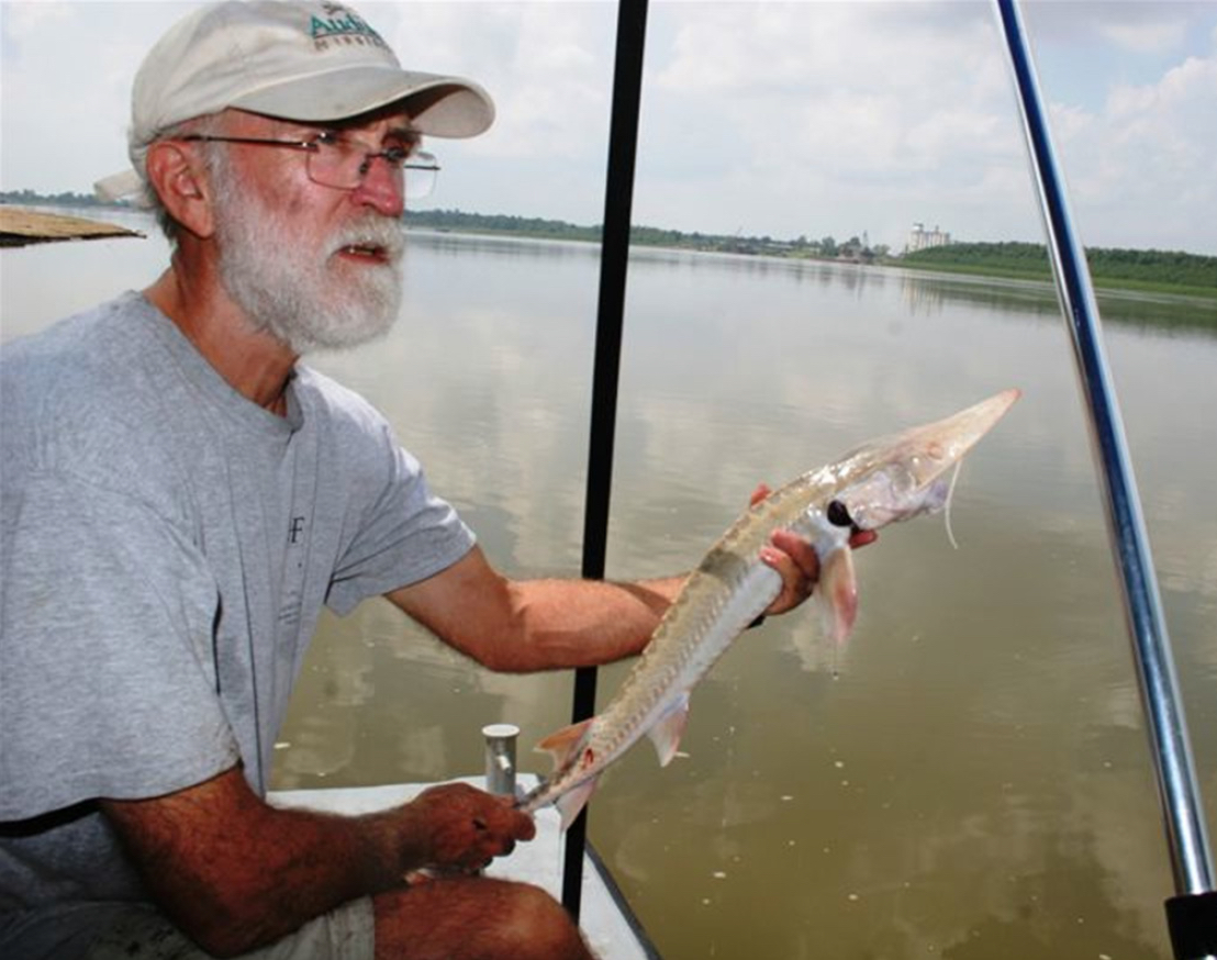
Paul Hartfield releases endangered pallid sturgeon. Photo by Bruce Reid, LMRCC.
Mississippi River Wilderness?
The WILD Foundation (2014) defines wilderness as “the most (biologically) intact, undisturbed wild natural areas left on our planet … that humans do not control and have not developed with roads, pipelines or other industrial infrastructure.” The Lower Mississippi River is highly developed, and significant efforts and resources are expended annually to control it; therefore, it seems unlikely that we could or should refer to it as a wilderness. However, a case might be made that although “developed,” the channel ecosystem is relatively “intact” and an example of wild nature.
The WILD Foundation (2014) suggests that “the essence of a wilderness area is that it is a place where humans can maintain a relationship with wild nature.” The Lower Mississippi River emanates wildness, offering hundreds of miles of opportunities to enjoy and reconnect with wild nature on a world-class river!
The Wild Mississippi River
Undeveloped, uninhabited, unmanageable, uncontrollable, unrestrained … these are all used as dictionary descriptors of wildness. In the conservation literature, one finds “wildness” used to reflect the autonomy of nature or that which is not controllable by humans (Evanoff 2005; Grumbine 1995). Wildness in nature is valued for spiritual and aesthetic reasons and is perceived as characteristic of functioning, complex, natural ecosystems.
The Lower Mississippi River retains a high degree of complexity and a functioning river channel ecosystem. Although access to its historical floodplain has been limited by levees, the river remains unconstrained by dams between those levees (Figure 2). Its autonomy arises from receiving the combined rainfall, snowmelt, and discharge of 40% of the continental United States. For example, the average discharge of the Lower Mississippi River is about 600,000 cubic feet per second (cfs) (16,990 cubic meters per second, cms) or, in other terms, 4.5 million gallons (17.1 million liters) of water passing every second. For comparison, the average discharge of the Missouri River is 87,520 cfs (2,478 cms).
Changes in high and low river stages of 30 feet (10 m) occur annually along the Lower Mississippi River, with a river stage variation of 40 ft (12 m) occurring every few However, discharge can vary even more dramatically, from a high of 2.2 million cfs (62,297 cms) in 2011 at Vicksburg, Mississippi, to less than 0.2 million cfs (5,663 cms) in 1988 and 2012. This translates into an almost 60-foot (20 m) vertical change in water height within the active floodplain at Vicksburg, Mississippi!
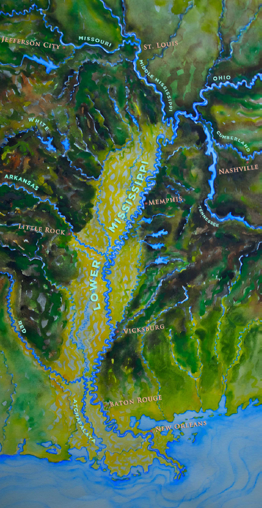
Figure 1 – Lower Mississippi River map.
In human terms, the natural hydrograph (timing, magnitude, and duration of unimpaired flow in response to weather and snowmelt) keeps the batture, or land on the river- side of levees, relatively undeveloped and sparsely inhabited. Even so, the extreme flows create local, regional, and even national economic chaos. Most agricultural exports from the Mississippi Basin move down the river by barge, passing barges moving upstream loaded with imports, and with industrial products moving both ways. Extreme low flow events transform the river from a six-lane commercial interstate to a one-lane country road, slowing navigation and affecting commerce throughout the Interior Basin; for example, the 1988 low water event brought hundreds of barges to a standstill and caused about $1 billion (U.S.) in economic losses. High water events affect not only commerce, but also land-based properties and infrastructure. Total economic damage estimates from the 2011 flood reached several billion dollars, as well as almost $2 billion in damage to the flood and navigation management infrastructure (Camillo 2012).
In ecosystem terms, it is the natural, sometimes extreme, hydrograph that builds and structures in-stream habitats and maintains the “wildness” and function of the Lower Mississippi River ecosystem. Annual high river stages not only regenerate secondary channels, oxbows, and back swamps, but they also restrict agriculture to only the most elevated lands between the levees, ensuring the dominance of bottomland forests within the river batture. Extreme high flow events maintain ecosystem and habitat complexity within the channel through periodically redistributing large quantities of sediment, maintaining or forming islands and secondary channels, and setting back plant succession on sandbars and low islands.
Wildness in Context
During the last century, large multipurpose dams were constructed throughout the larger tributaries of the Mississippi River to capture and store high seasonal precipitation or snowmelt. The purposes for these large dams are various, but most were intended to reduce downstream infrastructure flooding, and release stored water during dry seasons and droughts for irrigation, human consumption, electricity, and/or navigation (e.g., Missouri, Platte, upper Red, upper Arkansas, Upper Mississippi, Ohio, Tennessee, Cumberland Rivers). Lock and dam systems were also built to provide efficient year-round commercial navigation (e.g., lower Red and Arkansas Rivers, Ohio, Upper Mississippi). More than 50,000 smaller dams have been constructed throughout the Mississippi River watershed (Schneider 2013). Regardless of the purpose of the dams, they all functioned to reduce extreme flow events and variation in the river hydrographs, reduce sediment movement through the systems, and decrease river channel habitat complexity. Cumulatively, these dams and their impounded waters and controlled discharges have diminished or eliminated habitat values for many river-adapted species.
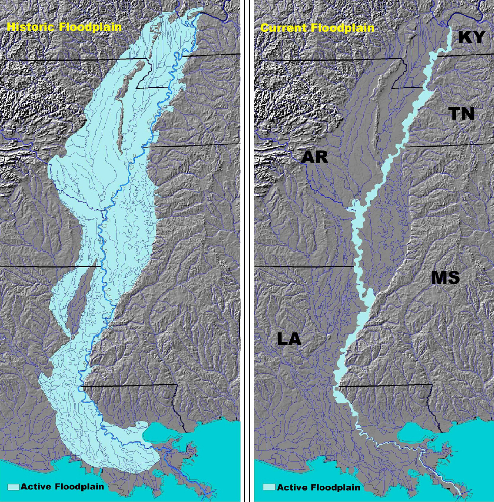
Figure 2 – The disconnection of the Lower Mississippi River from its historic floodplain has increased flood height between the levees and contributed to the Gulf of Mexico dead zone. Photo credit LMRCC.
Basin tributary dams affected the Lower Mississippi River through small shifts in the seasonal timing and duration of high and low flows, and diminished sediment input. However, these effects are attenuated in the Lower Mississippi River by the size of the basin drainage, the cumulative flows from all tributaries, the absence of dams, the constriction of the floodplain, and the high volume of “stored” channel sediment. Therefore, dams in the tributaries have had little effect on the dynamic nature of Lower Mississippi River flows or the complexity of its channel habitats.
The Lower Mississippi River channel ecosystem has been affected by human intervention. Channel engineering (e.g., river bend cutoffs, bank paving, dike construction) over the past 85 years by the U.S. Army Corps of Engineers (Corps), under the direction of Congress, to “fix” the channel in place, control flooding, and to develop an efficient and safe commercial navigation system in the Lower Mississippi River (Camillo 2012) have resulted in a gradual and cumulative diminishment of channel habitat complexity, measured by the loss of islands and secondary channels and floodplain connectivity at lower river stages.
Considering the extent of modification, and the separation of the river from 90% of its historical floodplain, the Lower Mississippi River channel ecosystem remains remarkably intact, especially in context with other large temperate river systems throughout the United States and the world. The forested batture and wetlands (Figure 3) remain critically important to hundreds of bird species, including Neotropical songbirds (hummingbirds, thrushes, flycatchers, warblers, and others), waterfowl (ducks and geese), colonial waterbirds (herons, egrets, pelicans, and others), shorebirds (sandpipers), gulls and terns, and other species closely associated with the river (e.g., eagles, osprey). The lower river channel itself is home to 109 of the 140 fish species resident to the entire Mississippi River (Schramm 2004), and there have been no known fish species extinctions or extirpations.
Even though the aquatic fauna is relatively intact, there have been changes in relative abundance of some channel species. For example, freshwater river shrimp (Machrobra- chium ohione) were once so abundant they were the target of a commercial fishery from St. Louis to New Orleans. Considered a delicacy in river towns and cities, as well as on steamboats, they supported an abundant harvest from the mid-1800s through the mid-20th century. During 1898, more than 200,000 pounds of river shrimp were reported harvested from the Lower Mississippi River (U.S. Fisheries Commission 1899) and the actual harvest likely exceeded that significantly. River shrimp are amphidromous, living and breeding in flowing fresh water but requiring a saline environment for larval development. Following a larval stage in the Gulf or an estuary, juvenile river shrimp migrate up the Mississippi River to grow, and were known to travel as far as 500 miles (805 km) up the Ohio River prior to its impoundment. After one or more years of growth, the adults swim downstream to breed and release their newly hatched larvae to drift into the salty waters of the coast. Today, collecting enough large shrimp for a single meal requires multiple traps over several days (personal observation). This decline is likely due to the increased current speed of the river resulting from decades of channel engineering, and/or by levees restricting access of the larvae to the saline estuaries lining the lower river. Even so, river shrimp remain common in the Lower Mississippi River, and the upstream movement of millions of tiny larval shrimp, and the return trip of the adults (up to a 2,000-mile [3,218 km] round-trip!) is one of the longest and most remarkable of North American faunal migrations.
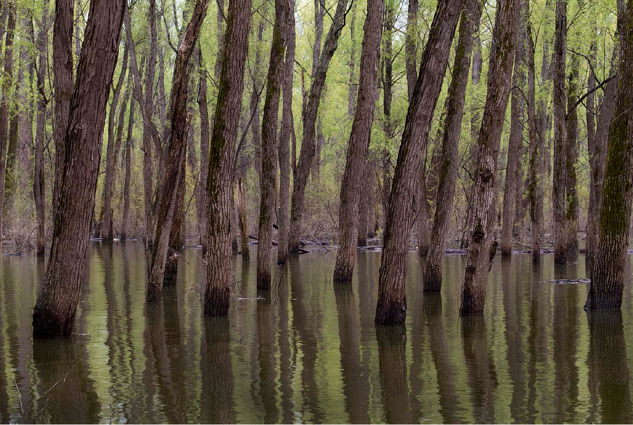
Figure 3 – Backswamps still exist between the levees, removing sediment, processing nutrients, and providing habitats for numerous species. Photo credit USFWS.
Among the resident species of the Lower Mississippi River that have been increasing in abundance are two federally protected species: the endangered interior least tern and pallid sturgeon. While these are obviously very different species, they have more in common than their present status under the Endangered Species Act (ESA). Both are species of extremes, found at the north/south extremes of the continental United States from Montana to the Gulf of Mexico, under climatic conditions ranging from boreal to semitropical, and in small rivers (e.g., Yellowstone River) to the largest (Lower Mississippi River).
The interior least tern and pallid sturgeon were protected under the ESA primarily because the construction of dams in the major tributaries of the Mississippi River (Missouri, Platte, Red, Arkansas, and Ohio Rivers) eliminated their nesting or recruitment habitats in large portions of these drainages. However, both species have been proliferating in the Lower Mississippi River over the past two decades.
When the interior least tern was listed under the ESA in 1985, only about 300 birds nesting in 11 colonies were known from a short reach of the Lower Mississippi (Hardy 1957; Downing 1980), constituting less than 20% of the range-wide population at that time. Over the past decades, nesting colonies have expanded from Cairo, Illinois, to Baton Rouge, Louisiana, and now support upwards of 12,000 terns per year, more than 60% of the listed population (Lott 2006; Lott et al. 2013; U.S. Fish and Wildlife Service 2013). Based largely on this remarkable recovery, the U.S. Fish and Wildlife Service recently considered the interior least tern as “recovered,” and have recommended delisting it under the ESA (U.S. Fish and Wildlife Service 2013).
Pallid sturgeons were also considered similarly historically rare in the lower river. When this fish was listed under the ESA (1990), only 28 historical records were known from the Lower Mississippi River (Keenlyne 1989). Analysis of recent collection data, however, indicates the population may now be as high as 20,000 fish (Friedenberg et al. 2013).
The recruitment habitats for both of these species are associated with river islands and secondary channels, which are formed, maintained, and dependent on extreme flow events, specifically periodic floods. These habitats remain relatively common in the Lower Mississippi River, and are now being purposely maintained through management (U.S. Army Corps of Engineers 2013).
Management of the Lower Mississippi River
Over the past decade, the Corps, U.S. Fish and Wildlife Service, and state conservation agencies along the lower river (AR, KY, LA, MO, MS, TN) have worked together under the Lower Mississippi River Conservation Committee (LMRCC) to experiment with and develop a management approach to maintain and restore features of the river ecosystem that are tied to its “wildness.” The management approach that has evolved is realistic, cost-effective, and, to date, has been extremely successful (U.S. Army Corps of Engineers 2013).
In order to reach a multiagency/ state management consensus, it was first necessary to establish baseline conditions on current ecosystem health and function, along with realistic expectations for outcomes. These were and continue to be closely linked. For example, synthesis of research data on current conditions led to recognition of the improved status of the two endangered species, the importance of the river corridor to migratory birds, the quality of fisheries resources, and other aspects of the overall quality and function of the Lower Mississippi River ecosystem (e.g., the continued presence and importance of river shrimp). Consideration of these in light of congressionally mandated requirements for flood control, navigation, ecosystem management, and future human demand in the United States and world for water and food (Montgomery 2007; Solomon 2007) led to the realization that river engineering is a component of the baseline ecosystem conditions, as well as a powerful ecosystem management tool.
Putting Wildness to Work
During the 1980s, the Corps began developing and testing engineering techniques and designs to mitigate the negative effects of channel engineering to the Lower Mississippi River habitats. Some of these (e.g., grooves in bank paving to increase aquatic insect productivity) were easily and readily incorporated into engineering designs. Others were more experimental in nature (e.g., notches in dikes, novel river structures such as chevrons and hardpoints, and beneficial placement of dredged materials) due to concerns for navigation and flood control infrastructure integrity (Figure 4).
By 2001, the Corps was prepared to work with its LMRCC partners to focus these tools on the habitat needs of species such as the interior least tern and pallid sturgeon, and to experiment with their uses to mitigate the ecosystem effects of almost a century of channel engineering. Novel channel engineering designs are intended to use the natural (wild) hydrograph to move excess sediments and water into areas important to the ecosystem and its species. Because these designs can be incorporated into planned channel construction and routine maintenance actions, they can also be implemented incrementally at little to no extra cost to the program.
The Corps works with LMRCC partners to cost-share the reengineering of secondary channels (more than 14 secondary channels over just the past few years, increasing flows and connectivity to more than 50 miles [80 km] of channel and thousands of acres of channel habitats). Following more than a decade of testing by the rise and fall of the river (including the record discharge of 2011), the Corps has adopted most of these modifications as channel engineering Best Management Practices in the Lower Mississippi River (U.S. Army Corps of Engineers 2013).
Multiple species of migratory birds and fish, including both the interior least tern and pallid sturgeon, are benefiting from the LMRCC partnership and the Corps’ new management strategy. Secondary channels, dike notches, and dike tips provide spawning and feeding areas for multiple game and forage fish species and are the most productive fisheries habitats in the Mississippi River. Another species that appears to be benefiting is the endangered fat pocketbook mussel, which has recently expanded its range into the Lower Mississippi River by colonizing secondary channels characterized by notched dikes (U.S. Army Corps of Engineers 2013). Secondary channels also provide safe fishing, paddling, and wildlife-viewing recreational opportunities outside of the navigation channel.
Because of the increasing societal demand for water, flood control, and commerce, the Lower Mississippi River is unlikely to return to its preindustrial wilderness condition. The Corps,U.S. Fish and Wildlife Service, and LMRCC partners have demonstrated the use of “wildness” as a management tool, and the ability to transform threats to endangered species and their habitats into conservation tools.
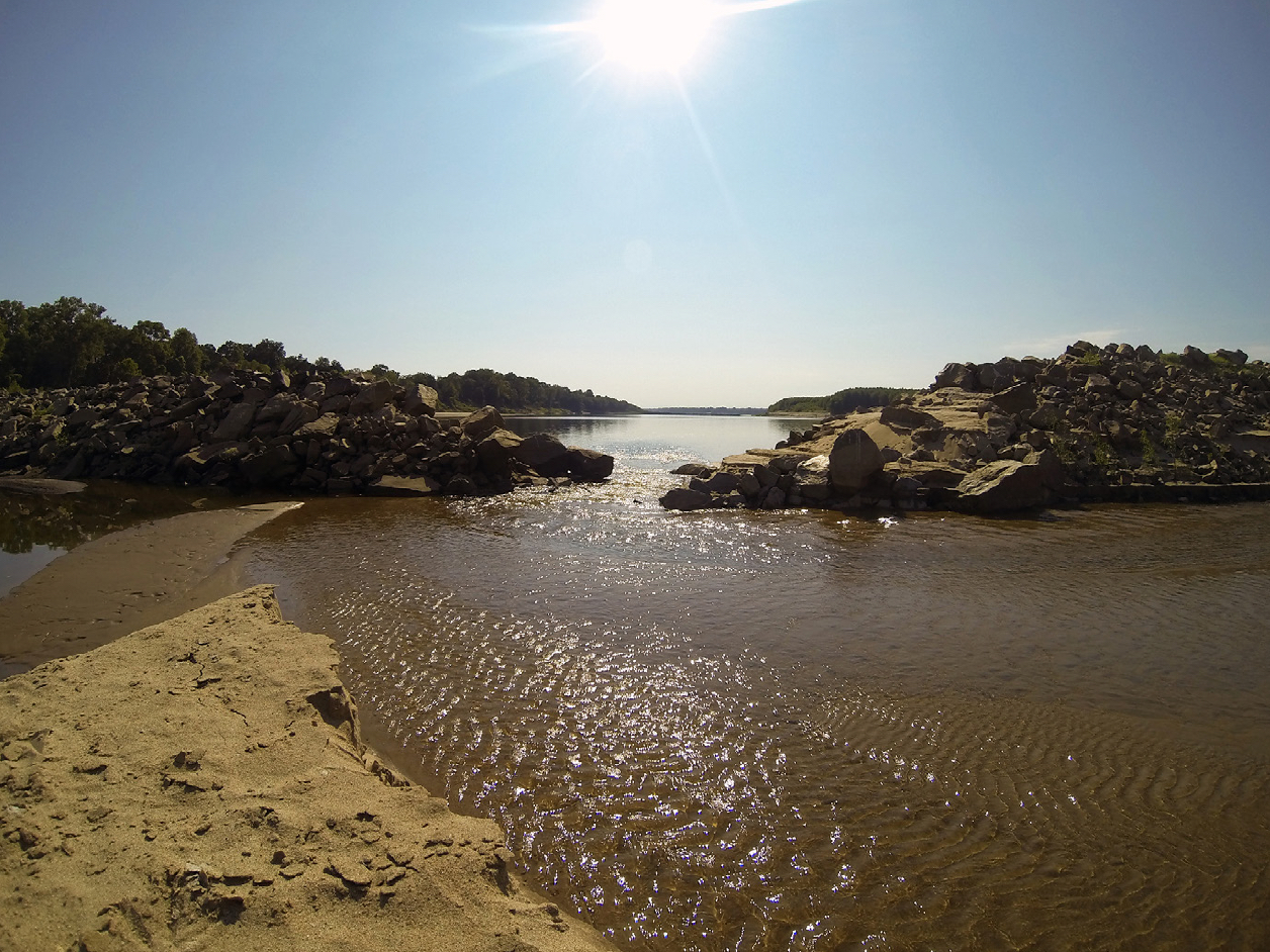
Figure 4 – A dike notch at the Shipland Wildlife Management Area maintains connectivity between the secondary channel and the river. Photograph by Bruce Reid, LMRCC.
PAUL HARTFIELD is an invertebrate biologist with U.S. Fish and Wildlife Service in Jackson, Mississippi; email: paul_hartfield@fws.gov.
VIEW MORE CONTENT FROM THIS ISSUE
References
Camillo, C. A. 2012. Divine Providence: The 2011 Flood in the Mississippi River and Tributaries Project. Vicksburg, MS: Mississippi River Commission.
Downing, R. L. 1980. Survey of interior least tern nesting populations. American Birds 34: 209–211.
Evanoff, R. J. 2005. Reconciling realism and constructivism in environmental ethics. Environmental Values 14: 61–81.
Friedenberg, N. A., J. J. Hoover, K. Boysen, and K. J. Killgore. 2013. Estimating pallid sturgeon (Scaphirhynchus albus) abundance in the Lower and Middle Mississippi River from the absence of recaptures. Entrainment Studies of Pallid Sturgeon Associated with Water Diversions in the Lower Mississippi River, November 15, 2013 (draft). Vicksburg, MS: U.S. Army Corps of Engineers, ERDC-EL: 29–46.
Grumbine, R. E. 1995. Wise and sustainable uses: Revisioning wilderness. In Wild Ideas, ed. D. Rothenberg (pp. 3–26). Minneapolis: University of Minnesota Press.
Hardy, J. W. 1957. The Least Tern in the Mississippi Valley. East Lansing: Museum of Michigan State University Biological Series, 1:1.
Keenlyne, K. D. 1989. A Report on the Pallid Sturgeon. Pierre, SD: U.S. Fish and Wildlife Service.
Lott, C. A. 2006. Distribution and Abundance of the Interior Population of Least Tern (Sternula antillarum) 2005: A Review of the First Comprehensive Range-Wide Survey in the Context of Historic and Ongoing Monitoring Efforts. ERDC/EL TR-06-13. Vicksburg, MS: U.S. Army Engineer Research and Development Center.
Lott, C. A., R. L. Wiley, R. A. Fischer, P. D. Hartfield, and J. M. Scott. 2013. Interior least tern (Sternula antillarum) breeding distribution and ecology: Implications for population-level studies and the evaluation of alternative management strategies on large, regulated rivers. Ecology and Evolution 3(10):3613-27.
Montgomery, D. R. 2007. Dirt: The Erosion of Civilizations. Berkeley: University of California Press.
Schneider, P. 2013. Old Man River. New York: Henry Holt & Co.
Schramm, H. L., Jr. 2004. Statusandmanagement of fisheries in the Mississippi River. In Proceedings of the Second International Symposium on the Management of Large Rivers for Fisheries, Volume 1, ed. R. Welcomme and T. Petr (pp. 301–333). Bangkok: FAO Regional Office for Asia and the Pacific, RAP Publication 2004/16.
Solomon, S. 2007. Water: The Epic Struggle for Wealth, Power, and Civilization. New York: Harper Perennial. Reprint edition, January 18, 2011.
U.S. Army Corps of Engineers. 2013. Conser- vation Plan for the Interior Least Tern, Pallid Sturgeon, and Fat Pocketbook Mussel, in the Lower Mississippi River (Endangered Species Act, section 7(a) (1)). Vicksburg, MS: U.S. Army Corps of Engineers, Mississippi Valley Division.
U.S. Fish and Wildlife Service. 2013. Interior least tern (Sternula antillarum) 5-year review: Summary and evaluation. Jackson, MS: U.S. Fish and Wildlife Service. Retrieved from http://ecos.fws.gov/docs/ five_year_review/doc4294.pdf.
U.S. Fisheries Commission. 1899. Report of the Commissioner for the Year Ending June 30, 1898. Washington, DC: Government Printing Office.
Wild Foundation, The. 2014. What is a wilderness area? Retrieved May 2014 from www.wild.org/main/how-wild-works/ policy-research/what-is-a-wilderness- area/.