Wenaha Wild and Scenic River. Photo credit © Robert Burns.
Monitoring Outdoor Recreation Use: The Umatilla National Forest, Wenaha Wild and Scenic River Corridor
Communication & Education
April 2020 | Volume 26, Number 1
ABSTRACT This case study sought to determine if current Weneha Wild and Scenic River Corridor recreation use is appropriate and compatible with the numerous applicable legislation and regulations. The study was conducted following a 2013 capacity analysis for the Wenaha River Comprehensive River Management Plan. The capacity analysis examined several items related to social carrying capacity, including parking at trailheads, campsite use, and group size, as well as information about recreationists’ characteristics and experiences. Quantitative data were collected in the form of vehicle counts, and field observational data were used to supplement the quantitative results. A document analysis was also performed using relevant documents, including federal legislation, Forest Service management plans and policies, and other federal, state, and county documents. Results confirmed that virtually all recreation use in the setting was appropriate and within established thresholds. With anticipated growth in recreation visitation, resource managers can focus on better cooperation and coordination with other agencies to improve management of the setting.
The political environment of the United States during the 1960s and 1970s quickly and drastically shaped the future of land management. This period gave rise to the Clean Water Act (1972), Endangered Species Act (1973), and Forest and Rangeland Renewable Resources Planning Act (1974) in just three short years (USDA Forest Service 2005). Two key legislative actions from this period were important for this study: The Wilderness Act of 1964 and the Wild and Scenic Rivers Act of 1968.
The Wilderness Act, arguably the most significant piece of legislation to federal land managers in the United States, defines wilderness, in part, as “an area where the earth and its community of life are untrammeled by man, where man himself is a visitor who does not remain” (Wilderness Act section 2 [c]). These lands are the most highly protected lands in the United States, as use of these areas is the most restricted and the terms of the Wilderness Act supersede those of other land management laws. Policy development, management plans, and day-to-day decisions are guided by the act for all federally designated wilderness lands.
The Wild and Scenic Rivers Act (WSRA) was signed into law in 1968, just four years after the Wilderness Act. The WSRA states that designated rivers “shall be preserved in free-flowing condition, and that they and their immediate environments shall be protected for the benefit and enjoyment of present and future generations” (WSRA section 1[b]). To be designated, a river must possess at least one “outstandingly remarkable value” (ORV), which has been defined as “a unique, rare, or exemplary feature that is significant at a comparative regional or national scale” (USDA Forest Service 2015a). Whether a river possesses such a value is to be determined by the federal land management agency that manages that river.
The Oregon Omnibus National Wild and Scenic Rivers Act of 1988 amended the WSRA of 1968, granting federally protected status to dozens of Oregon rivers and river segments including the Wenaha Wild and Scenic River (WSR). The Forest Service was named as responsible for the protection of the Wenaha WSR (section 102), and the Forest Service also determined it to possess four outstandingly remarkable values: recreation, scenery, wildlife, and fisheries (USDA Forest Service 1992). The Umatilla National Forest (NF) was thereby required to develop a Comprehensive River Management Plan (CRMP) for the river. The Wenaha WSR CRMP (USDA Forest Service 2015b) outlines goals and standards to protect and enhance the ORVs for which the river was designated into the WSR system, while providing for public use and enjoyment of the WSR (USDA Forest Service 2015b).
There are also lands and natural resources within and adjacent to the WSR that are administered by other federal, state, and local agencies. Although the Forest Service has jurisdiction over areas within the WSR, it may not enforce its rules outside of its boundaries. Thus, interagency cooperation is necessary to achieve management objectives and to ensure consistency in management and enforcement. This means the Forest Service must collaborate with other agencies and stakeholders to ensure that river values are protected on the 2.9 river miles (4.7 km) that extend beyond the forest boundary.
Purpose of Study
The Wenaha WSR depends on recreation, scenery, wildlife, and fisheries ORVs for its character and the types of recreation opportunities it provides. The Forest Service and collaborating agencies are directed to maintain (and enhance) ORV conditions that are consistent with (or exceed) conditions at the time of designation (USDA 2015b). To accomplish this, the Forest Service and collaborating agencies must balance “appropriate” levels of use and protection of outstanding remarkable values. This task can become challenging, as a river’s classifications may also inform decisions regarding user capacities and protection of resources across different river segments. WSR river classifications vary in levels of accessibility, user capacity, and ORV sensitivity to degradation (e.g., erosion, bank trampling, loss of vegetation). Thus, “appropriate” levels of use are those that achieve and maintain the desired conditions established within the CRMP (IWSRCC 2018).
The Forest Service must address user capacities and develop management actions to ensure that use levels stay within the established capacities directed by the CRMP. A visitor capacity analysis was prepared in 2013 for the Wenaha WSR with recommendations for the desired conditions, standards, and guidelines for the recreation ORVs. Managers are required to monitor current use levels and determine if those levels are consistent with, or threaten, the established desired conditions for those resource values (IWSRCC 2018). This requires evaluating visitors and trends over time in the amounts, types, and distribution of recreational use throughout the Wenaha WSR. Assessments of visitor use levels inform management on whether those levels are compatible with the visitor capacity established for a WSR area and help determine the amount of investment needed to support changing visitor capacity decisions (IVUMC 2019).
The Interagency Visitor Use Management Council (IVUMC) recently published a new visitor management framework, developed collaboratively across federal natural resource agencies (IVUMC 2019). This framework offers a flexible, iterative, and responsive process to develop, implement, and monitor visitor use. It describes a sliding scale approach to assess resource impacts that provides guidance in matching the investment in time and money needed to monitor and address impacts, and to commensurate levels of impact, uncertainty, and risk related to the resource (IVUMC 2019). For instance, visitor capacity scenarios in which the levels of impact risk and issue uncertainty are relatively low may indicate that less investment is needed at that time. On the other end of the spectrum, high levels of impact risk and issue uncertainty would warrant a higher amount of investment. The purpose of this case study was to understand if existing recreational use in the Wenaha WSR can be considered appropriate and within established capacities, in accordance with the many different guiding documents, regulations, and legislation.
Study Area
The Wenaha-Tucannon Wilderness (WTW) is in the Umatilla NF, located in the Pacific Northwest of the United States, in northeastern Oregon and southeastern Washington. The specific study area included the 21.5 miles (35 km) of the Wenaha Wild and Scenic River and areas that access the river corridor. The Wenaha WSR study area was segmented into four categories based on their designated segments within the CRMP (2015): (1) Wild River (Wilderness), (2) Wild River (Nonwilderness), (3) Scenic River, and (4) Recreational River sections. These categories vary in accessibility and level of surrounding development. Wild Rivers are primitive without development and are mostly accessible by trail, whereas Recreational Rivers are accessible by road or rail and may have shoreline or watershed developments, and Scenic Rivers fall in between Wild and Recreational Rivers accessibility and development levels.
The Wild River segment consists of 18.7 river miles (30 km) within the Umatilla NF boundary, and 15.2 (24 km) of those miles are also within the Wenaha-Tucannon Wilderness (USDA Forest Service 2013b). The majority of the wilderness corridor is characterized by remote wild landscapes and is not typically used for recreational floating. The remainder of the Wild River (3.5 miles/6 km) is outside of the wilderness (i.e., nonwilderness) but still within the Forest Service boundaries. The Scenic and Recreational River sections flow through the Wenaha State Wildlife Area and include a mix of state, private, and federal lands administered by the Bureau of Land Management (BLM). Private and BLM-administered lands in these sections are primarily used as forest or pasture, for residential living, and for private business. The Scenic River section (2.7 miles/4 km) is located outside of the wilderness and Forest Service boundaries. Much of this section is still remote, providing recreation opportunities similar to those provided by the Wild River sections. The Recreational River section (extending only 0.15 mile/.24 km) is found in the last river mile in which the community of Troy, Oregon, greets the mouth of the Wenaha just before its confluence with the Grande Ronde Wild and Scenic River. Recreation visitation is low, and the vast majority of visitors report a high level of satisfaction (Burns, Popham, and Smaldone 2018).
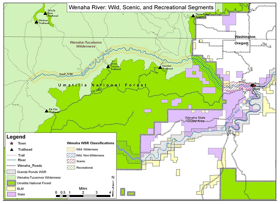
Figure 1 – Map of the Wenaha Wild and Scenic River classifications (USDA Forest Service 2015b).
Methods
Four stages of research were utilized to understand existing recreational use in the Wenaha WSR : (1) a review of federal legislation, Forest Service documents, and other regulations; (2) quantitative data collection through surveys and vehicle counts (Burns, Popham, and Smaldone 2018); (3) field observations; and (4) an analysis of existing visitor use compliance with the goals and expectations outlined in the documents. The documents were reviewed to understand the desired levels of use within the Wenaha WSR. The data collection and field observations were conducted to determine the levels of “current recreational use” in the study area and analyze those levels for consistency with the agency’s guidelines. Current recreational use was determined by a series of indicators or social attributes that can be measured to track changes in conditions associated with human use. These indicators are specified within the Wenaha WSR CRMP (USDA Forest Service 2015b). This study focused on four of those recreational use indicators: (1) group size, (2) group encounters, (3) vehicle use, and (4) recreational activity type. These data were analyzed for consistency with the desired use levels outlined in the documents.
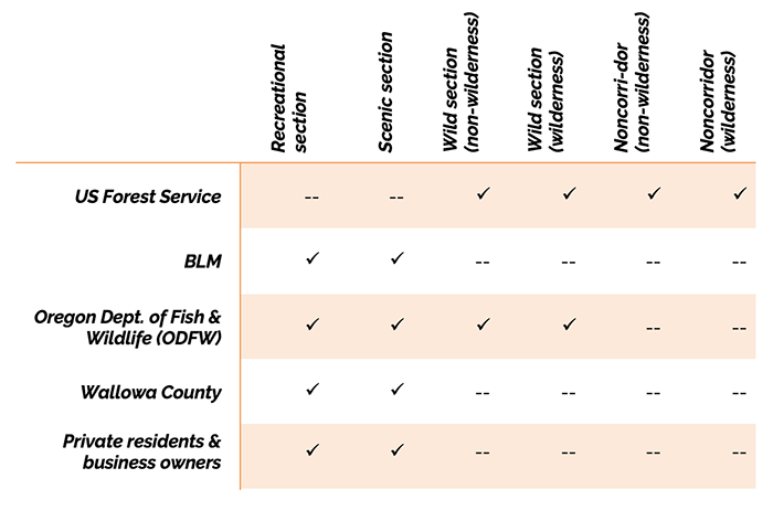
Table 1 – – Stakeholders with direct administrative authority within the Wenaha Wild and Scenic River study area.
Document Review
Documents were obtained through meeting and speaking with natural resource agency managers from several agencies listed and through web searches. Not only were the myriad guiding documents challenging to navigate, but the study area is itself extremely complex because many jurisdictions are involved. Table 1 shows which agencies or other stakeholders have direct administrative authority in different portions of the study area. It is important to note that management efforts should be cooperative and collaborative in planning and regulation, and each stakeholder is involved at different levels with the administration of many parts of the study area.
The second step was to organize all relevant documents into three categories: (1) primary, (2) secondary, and (3) tertiary (Figure 2). Primary documents included federal legislation; those documents are most authoritative. However, not all current use was addressed by these documents – they provide loose direction but also grant agencies authority to manage details. Secondary documents were also analyzed, including Forest Service plans, policies, and directives that provide specific management direction. Tertiary documents included other federal (BLM), state, and county plans and regulations that are important for managing the study areas of the river corridor that lie outside the Forest Service boundary.
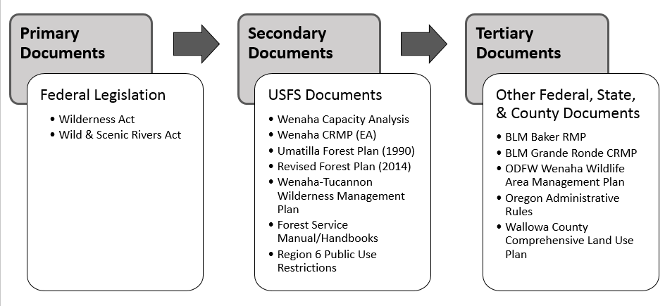
Figure 2 – Document Organization developed during Document Review Analysis.
A variety of documents provide management direction for different portions of the study area (Table 2). Because these documents often complement one another, all are arguably applicable to the entire study area. For example, the Forest Service Manual and Handbooks discuss general management of Wild and Scenic Rivers. However, the documents noted in the following tables provide the most specific and relevant criteria by which to evaluate appropriate use.
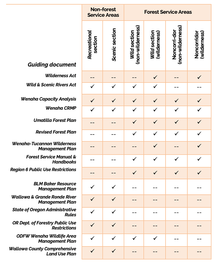
Table 2 – Documents used to evaluate appropriate use in the Wenaha Wild and Scenic River study area
Survey
An onsite survey was used to collect visitor data on a variety of topics including demographic and group characteristics; visitor perceptions related to crowding, conflict, and satisfaction; encounters with other visitors; and activity participation. The survey was developed as part of a larger visitor study conducted in the Wenaha WSR from mid-June through early August of 2014 (Burns, Popham, and Smaldone 2018). Survey items of relevance to this study included three of the four recreational use indicators: (1) group size (the number of adults and children in a group), (2) group encounters (the number of times recreationists encounter other groups), and (3) participation in recreational activities (based on a list of 23 potential activities). A total of 74 surveys were collected at trailheads accessible to the Wenaha River corridor and at campsites in Troy.
Vehicle Counts
Vehicle counts can be used to represent people at one time (PAOT) in an area (Lawson, Manning, Valliere, Wang, and Budruk 2002). Vehicle counts were conducted upon arrival and departure from the survey site locations. Following the same method used in the Forest Service capacity analysis (USDA Forest Service 2013a), vehicles at trailheads or other locations with attached trailers (of all types) were counted as one vehicle.
Also following the capacity analysis methodology, vehicles at all 20 campsites were included for the Troy private campground count. For the Elk Flat Trailhead (TH), vehicles or trailers are often parked in a location approximately 0.25 mile (.40 km) from the actual trailhead. These vehicles were included in the Elk Flat TH count. Counts were recorded on paper to be entered into a spreadsheet every time the interviewer arrived at or departed a survey site location.
Field Observations
Reporting field observations is an effective method of supplementing quantitative research (Axinn and Pearce 2006; Onwuegbuzie and Leech 2005). This method provides context and can result in richer explanations than quantitative reporting alone (Sieber 1973). Observational data were collected via field notes and photographs taken at survey locations and on trails within the study area. Observations were determined noteworthy based on knowledge gathered both prior to and during data collection, especially if observations were made related to potential issues that were not addressed by the survey. For example, the presence of campsite litter was noticed, but the survey instrument did not include items related to this issue. This was considered important, as results from the 2011 capacity analysis defined litter as an inappropriate use and a threat to visitor capacity.
Analysis of Existing Use Compliance
The data collected from surveys, vehicle counts, and field observations were evaluated to determine “current recreational use” levels. The amount of recreational use was measured by the visitors’ group size, number of encounters with other groups, number of vehicles at the study site, and the types of recreation activities in which the visitors participated. These data were then evaluated for consistency with applicable legislation and regulations.
The method used to determine if current recreational use was appropriate was adapted from the “Appropriate Use Protocol,” suggested by the Federal Interagency Task Force on Visitor Capacity on Public Lands (Haas 2002). This method involves completing a worksheet that uses criteria that can help managers decide whether a specific recreational use is appropriate for an area. In the protocol, 21 decision criteria were identified, and examples included: “Does the use comply with applicable statutory requirements? (Yes/No)” and “Will the use significantly impact desired future conditions? (Yes/No).” At the conclusion of the evaluation, the decision maker reports whether use is appropriate or not appropriate.
The protocol’s decision criteria were modified for this study to determine appropriate use for the study area. The added questions below reflect the organization of the documents (primary, secondary, and tertiary) used to determine what is considered appropriate use for the Wenaha WSR. (The “Not Applicable” category was added, as Forest Service documents and state/other federal documents often did not apply to the area being evaluated.)
- Does the use comply with applicable federal legislation? (Yes/No/N/A)
- Does the use comply with applicable Forest Service documents? (Yes/No/N/A)
- Does the use comply with applicable other federal and/or state policies? (Yes/No/N/A)
Results
Group Size
Data collected during the sampling period suggested that group sizes were appropriate for the areas evaluated. Group size is regulated in wilderness in order to provide “outstanding opportunities for solitude” (Wilderness Act section 2[c]). Regulating group size also can be used to uphold the WSRA for those rivers that have been identified as possessing recreation as an outstandingly remarkable value, because regulating group size can help protect social carrying capacity (Manning 2011; Whittaker et al. 2011). While federal legislation does not specify group sizes in wilderness, land management agencies do. Therefore, Forest Service (secondary) and other agency (tertiary) documents were used to evaluate appropriate group size for the area.
The Wenaha-Tucannon Wilderness Management Plan (WTWMP) (USDA Forest Service 1989), the Revised Forest Plan (USDA Forest Service 2014), and the CRMP (2015) all specify the maximum group size as 12 persons/18 head of stock for those areas in wilderness. The CRMP also proposed a new standard that would extend this limitation of 12 persons/18 head of stock for that portion of the Wild river segment that is outside of wilderness. While the CRMP cannot enforce group size for lands outside of forest boundaries, another guideline proposed by the CRMP is that those nonforest entities that manage the Scenic river section should incorporate a group size limit that is consistent with these limits within the Wild section. However, this limit has yet to be determined. No known state or other document addresses group size limits for the Scenic or Recreational segments, and therefore this measure could not be applied in these areas. The CRMP does recommend a maximum number of PAOT for the entire river corridor, a measure used in tandem with vehicle capacity recommendations.
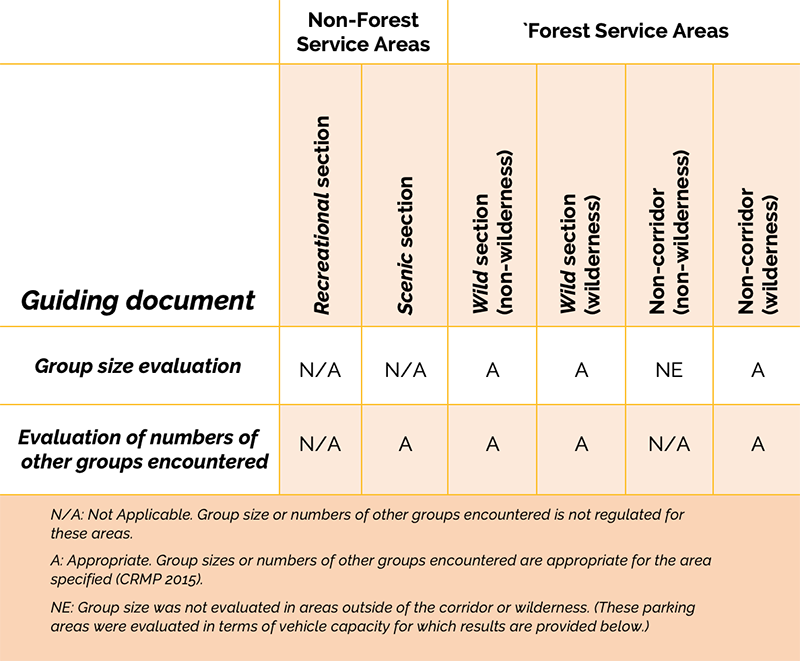
Table 3 – Appropriate use: Group size and numbers of other groups encountered in the Wenaha Wild and Scenic River study area (by River Corridor Section)
The mean group size reported by this study was 3.97 (Table 3). Only one group was larger than the 12 persons limit, and there was a party of 30 on the private campground in Troy on a holiday weekend. Parties recreating within those areas with group size regulations included just three separate parties of 11 people. No groups on Forest Service–managed land exceeded the limit of 12 people or 18 head of stock.
Group Encounters
The number of times recreationists encounter other groups is another indicator that managers can investigate in order to protect opportunities for solitude in wilderness and social carrying capacity in general. The CRMP and the Wilderness Plan were the only documents that addressed group encounters for the study area. The CRMP states that encounters of no more than three to six other groups within the river corridor (excluding the recreational section) are appropriate, allowing for more encounters during “peak visitation” (which includes about 10 days per year, such as certain holiday weekends). The mean number of encounters with other groups during the sampling period in the corridor was < 1.00 (0.97). This number excludes those who only used the recreational section and/or that portion of the scenic section which is the state campground. As this mean number of encounters was well below the three to six group encounter threshold identified in the CRMP, existing use was compliant in the corridor according to this measure (Table 3). Use outside of the corridor in wilderness was also appropriate. For those visitors who recreated in non-corridor wilderness areas (n=11) the mean number of other groups encountered was 1.00. This number is appropriate according to the standard set by the Wilderness Plan (USDA Forest Service 1989), which states that this semiprimitive wilderness area should maintain an 80% probability of encountering 10 or fewer other groups per day.
Vehicle Use
Appropriateness of vehicle use was assessed by comparing vehicle counts with thresholds outlined by Forest Service documents. Observational data revealed some inappropriate use regarding the exact locations of where visitors were choosing to park at trailheads and other locations, and also two isolated cases where vehicle use violated specific wilderness restrictions.
Vehicle count data were compared to the recommended standard set by the CRMP (2015). One method used by the Forest Service to estimate visitor use and to set use limits is through associating numbers of vehicles with numbers of PAOT, where one vehicle represents a count of four PAOT. Specific thresholds were identified in the CRMP and were based on results from the capacity analysis conducted in 2011. The CRMP focused on the total vehicle capacity for only those trailheads that most easily access the corridor and set this standard at 50 vehicles. This standard was not exceeded (Table 4). Even when considering the maximum number recorded for all trailheads simultaneously, the total count (N=26) of vehicles is only half of the set standard (50 vehicles).
The Forest Service did not set a standard for the private campground in Troy and the state campground, as the agency cannot enforce standards on nonforest lands. No known state or other document reports vehicle capacity or sets standards for vehicle capacity for these areas. The Forest Service lists 20 vehicles as the capacity for the private campground in Troy (USDA Forest Service 2013a). The maximum count recorded at one time by this study was 21 vehicles (including trailers), and the mean for the entire sampling period was 1.95 (Table 4). For state lands, capacity is reported as 10 vehicles. This capacity was only exceeded on one high use day, when 12 vehicles were counted. The mean was much lower, 1.03 vehicles. Table 4 compares the maximum vehicle counts recorded on state and private lands with the existing capacity reported in the capacity analysis (USDA Forest Service 2013a). Accordingly, the use of vehicles and parking areas with regard to numbers of vehicles is appropriate for the study area.
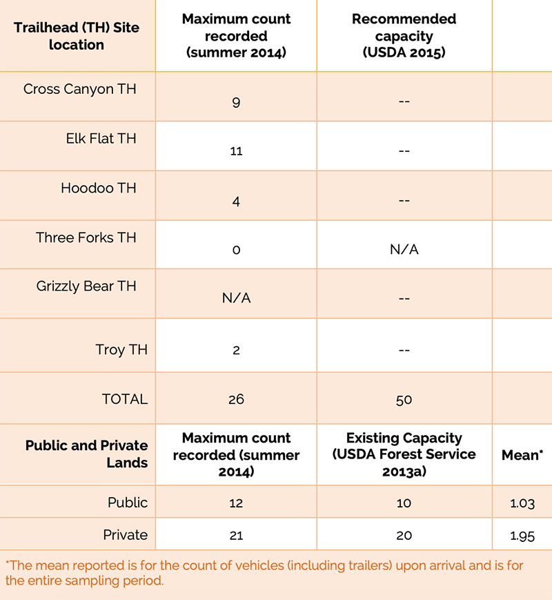
Table 4 –Vehicle counts at trailheads, state and private lands compared to recommended and existing capacity levels
Recreational Activities
“Recreational activities” included all recreational activity survey items listed on the survey instrument (Popham 2015). Each activity was evaluated to ensure that the activity was appropriate for all areas of the river corridor and noncorridor areas during the sampling time frame by checking the activity with management documents (Table 2) and the modified “Appropriate Use Protocol” noted earlier (Haas 2002). All activities were deemed appropriate, but observational data supplemented these results and did identify some instances of inappropriate use (Table 5). The most notable pertained to litter in campsites. The 2011 capacity analysis conducted by the Forest Service included an impact assessment of 131 campsites (USDA Forest Service 2013a). Each campsite was rated based on the presence of ground disturbance, tree damage, area disturbance, litter, human waste, weeds, user-created trails, and an overall impact rating (Cole 1983). Results showed a “low” overall impact rating for 128 of the 131 campsites of the corridor, and the remaining 3 showed “moderate” impact.
Some user-developed trails and trail impacts were noted through interviewer observational data (Table 5). According to the capacity analysis (USDA Forest Service 2013a), one inappropriate use identified as having a higher potential impact on visitor capacity is “unmanaged recreation use causing excessive permanent destruction of vegetation or multiple user-developed trails; especially along the banks of the river” (pp. 9, 11). Some evidence of user-developed trails was noted in all sections of the river corridor.
Discussion
In general, the answer to the question of whether recreation use is compliant and appropriate for the Wenaha WSR is “yes.” The CRMP (2015) developed for the Wenaha defines what uses (and use levels) are appropriate or inappropriate for the study area. When data collected for this study were compared to these thresholds, recreational use within the study area was determined to be appropriate with very few exceptions. If use remains low and monitoring continues to indicate the CRMP standards are not being exceeded, a sliding scale approach as recommended in the recent IVUMC (2019) framework would indicate that higher levels of investment are not needed. However, the management complexity related to the Wenaha WSR indicates that some issues remain to be addressed.

Table 5 – Appropriate use: Other recreational activities in the Wenaha Wild and Scenic River study area (by River Corridor Section).
Group sizes in the study area were appropriate and acceptable as they were well below the thresholds identified by the CRMP (2015). The CRMP proposed a new standard to limit group sizes to 12 people/18 head of stock in the Wild section outside of wilderness. It also proposed a new guideline to work with nonforest entities to incorporate a group size limit in the management of the Scenic section of the river corridor. This is important, as no other federal, state, or county document addresses group size on nonforest lands in the study area. This action would help protect and enhance the recreation ORVs, as these remote areas are comparable to the regulated Wild section. Should recreational use in the study area increase, it is recommended that the Umatilla NF monitors group sizes within the corridor to ensure that visitor capacity is not exceeded.
Regarding group encounters, the numbers of other groups encountered by recreationists are appropriate for the study area. Group encounters are only addressed by Forest Service documents, and although the Scenic section of the river lies outside of Forest Service boundaries, the CRMP suggests three to six should be the maximum number of encounters in this and the Wild section of the corridor. Use levels were well below this threshold during the time of data collection. As with group size data, the number of group encounters currently occurring shows that current management guidelines are being met. The number of encounters of other groups should continue to be monitored to see if recreational use in the study area increases.
The number of vehicles parked at trailheads and other parking areas was appropriate for the study area, as it was well below the threshold proposed by a new guideline in the CRMP (USDA Forest Service 2015). On rare occasions, visitors parked in shaded areas just outside of designated trailhead parking. As parking in vegetation can harm native species and contribute to the spread of invasive species, monitoring trailheads for invasive species and assessing vegetation impacts would be helpful.
The types of recreational activities that occurred in the study area were generally appropriate (as identified within the CRMP), with only a few exceptions, particularly regarding campsite use. Even small numbers of campers can negatively impact the river’s outstandingly remarkable values, and litter at some campsites threatens all four of the Wenaha’s ORVs (USDA Forest Service 2015). While annual monitoring of all corridor campsites may not be feasible for this area, it is suggested that at least the more convenient campsites located at trail intersections be monitored when possible. These are often, although not always, more popular sites, and have greater potential for increased use. In addition, the location of some campsites in wilderness near the river was inconsistent with the proposed guideline of the Revised Forest Plan (USDA Forest Service 2014). The CRMP guidelines for campsite management advised a reduction in the number of campsites through resting or closing those sites that are more highly impacted in the corridor. This reduction in campsites is regulated to achieve the “desired future conditions” section of the CRMP, which proposed the reduction of streamside sites.
Observational data also found evidence of user-created trails in the study area. Resource managers are aware of this and have addressed the issue through two proposed guidelines in the CRMP (USDA Forest Service 2015). These focus on user-created trails in riparian areas that have the potential to negatively affect ORVs. According to the CRMP, Leave No Trace (LNT) principles are encouraged in the area. Additional educational materials could focus on two of the seven LNT principles: “Leave what you find” and “Minimize campfire impacts” (Leave No Trace 2015). Posting information and interpretive messages at visitor centers and at wilderness trailheads could be beneficial, along with posting public use restrictions. Research on nonpersonal interpretation shows that simple messages can be one of the most successful delivery methods (Ham 2013).
In cases of areas with overlapping jurisdictions, agencies tend to default to the more specific management plans and policies developed by other agencies for a given area, and rightly so.
Management Implications and Conclusions
Management complexities due to the overlapping jurisdictions within the study area should be addressed, particularly if recreational use increases in the future. The inherent administrative complications that can arise in areas with complex jurisdiction situations have presented challenges for land managers for a long time (Lewis and Marsh 1977). The most specific direction for the study area comes from Forest Service documents. However, the Forest Service cannot enforce regulations outside of its boundaries, and few specific rules and regulations pertaining to recreation in the Wenaha corridor are defined for those portions of the study area that are on non-Forest-Service lands. In cases of areas with overlapping jurisdictions, agencies tend to default to the more specific management plans and policies developed by other agencies for a given area, and rightly so.
Nevertheless, confusion can still occur, and implications can be felt at a micro level. For example, on one occasion during this study a US Forest Service resource manager suggested that on the state-managed campground BLM rules are followed regarding the use of fire pans. On a separate occasion, a BLM employee explained that the BLM has no authority over state land at all, and that the state must regulate its own lands. Thus, two federal employees appear to be contradicting each other regarding specific rules. Regulatory guidance indicated that if the state wished to follow BLM rules, then regulations should have been developed requiring mandatory fire pans as prescribed by the Wallowa and Grande Ronde Rivers Management Plan (USDI BLM 1993, p. 138). However, if the state were to follow its own Oregon Administrative Rules (OARs), rock fire rings are inappropriate for this area, as they violate the OAR specifying that fire should be contained in fireproof containers (fire pans) within this portion of the Wenaha river corridor.
This is an example that illustrates the difficulties that can arise when multiple agencies are involved in managing an area. Interagency councils have been created in recent years to help coordinate management of complex areas such as wildernesses (e.g. Interagency Wilderness Policy Council) and Wild and Scenic Rivers (Interagency Wild and Scenic Rivers Coordinating Council 2018) and recently, the Interagency Visitor Use Management Council was formed to focus specifically on visitor use management on federal lands (IVUMC 2019). However, all three of these councils are composed of exclusively federal land management agencies. No state or other entities are included. Therefore, it is up to federal agencies to engage these other entities to ensure that the details of management plans are understood and applied. Incorporating state level and private stakeholders into the management process would serve the federal agencies well (Selin and Mendoza 2016).
As previously mentioned, the US Forest Service is very aware of other agency plans and activities in the study area and have incorporated that consideration into Forest Service management plans. Further, the CRMP (2015) proposed a “cooperative management” guideline, which will encourage other agencies to adopt a group size limit on nonforest lands (in the Scenic river corridor section) that is comparable to Forest Service limitations. Cooperative management will be very important for the non-Forest-Service lands of this study area, especially if recreational use increases. Numbers of visitors would likely increase on the more accessible Scenic and Recreational sections of the river corridor that are outside of Forest Service boundaries. Therefore, future collaboration among agencies might be warranted in order to ensure those visitor capacity thresholds defined for the CRMP are not exceeded. Purposeful collaboration between all stakeholders will help to ensure consistency in agency planning, which can and should result in better management of our public lands.
Funding for this research study was provided by the US Forest Service (Agreement14 DG-11132762-156) and the National Institute for Food and Agriculture.
DR. ROBERT C. BURNS is professor and director of the West Virginia University Division of Forestry and Natural Resources; email: Robert.Burns@mail.wvu.edu.
DR. DAVID SMALDONE is associate professor of Recreation, Parks and Tourism Resources at the West Virginia University Division of Forestry and Natural Resources; email: David.Smaldone@mail.wvu.edu.
DR. MARY E. ALLEN is a postdoctoral research associate at the West Virginia University Division of Forestry and Natural Resources; email: Mary.Allen1@mail.wvu.edu.
ASHLEY R. POPHAM is a resource assistant for the US Forest Service, Mt. Hood National Forest, Oregon; email: apopham@fs.fed.us.
References
Axinn, W. G., and L.D. Pearce. 2006. Mixed Method Data Collection Strategies. Cambridge, UK: Cambridge University Press.
Burns, R. C., A. Popham, and D. Smaldone. 2018. Examining satisfaction and crowding in a remote, low use wilderness setting: The Wenaha Wild and Scenic River case study. International Journal of Wilderness 24(3): 40–54.
Clean Water Act, US Code 33 (1972), § 1251 et seq.
Cole, D. N. 1983. Assessing and monitoring back-country trail conditions. Research Paper. INT-303. Ogden, UT: USDA Forest Service.
Endangered Species Act, US Code 16 (1973), § 1531 et seq.
Forest and Rangeland Renewable Resources Planning Act, US Code 16 (1974), § 1600 et seq.
Haas, G. E. 2002. Visitor Capacity on Public Lands and Waters: Making Better Decisions. Ashburn, VA: National Parks and Recreation Association.
Ham, S. H. 2013. Interpretation: Making a Difference on Purpose. Golden, CO: Fulcrum Publishing.
IVUMC (Interagency Visitor Use Management Council). 2019. Visitor Capacity Guidebook: Managing the Amounts and Types of Visitor Use to Achieve Desired Conditions. Lakewood, CO. https://visitorusemanagement.nps.gov/VUM/Framework.
IWSRCC (Interagency Wild and Scenic Rivers Coordinating Council). 2018. Steps to Address User Capacities for Wild and Scenic Rivers. A Technical Report of the Interagency Wild and Scenic Coordinating Council. Washington, DC, 23.
Lawson, S., R. Manning, W. Valliere, B. Wang, and M. Budruk. 2002. Using simulation modelling to facilitate proactive monitoring and adaptive management of social carrying capacity in Arches National Park, Utah, USA. In Proceedings: Monitoring and Management of Visitor Flows in Recreational and Protected Areas (pp. 205–210), ed. A. Arnberger, C. Brandenburg, and A. Muhar. Vienna: Bodenkultur University.
Leave No Trace Center for Outdoor Ethics. 2015. Leave No Trace. https://lnt.org, accessed August 27, 2015).
Lewis, D. E., and G. G. Marsh. 1977. Problems resulting from the increased recreational use of rivers in the West. In Proceedings: River Recreation Management and Research, USDA Forest Service General Technical Report, NC-28, pp. 27–31.
Manning, R. E. 2011. Studies in Outdoor Recreation, 3rd ed. Corvallis: Oregon State University Press.
Onwuegbuzie, A. J., and N. L. Leech. 2005. On becoming a pragmatic researcher: The importance of combining quantitative and qualitative research methodologies. International Journal of Social Research Methodology 8(5): 375–387.
Popham, A. 2015. An Assessment of Recreational Use: The Wenaha Wild & Scenic River,
Umatilla National Forest, Oregon. Master’s thesis, West Virginia University, Morgantown.
Selin, S., and C. Mendoza. 2016. Collaborative planning and public participation: Emerging design and strategy. In Outdoor Recreation Planning (pp. 133–158), ed. J. M. Baas and R. C. Burns,. Urbana, IL: Sagamore.
Sieber, S. D. 1973. The integration of fieldwork and survey methods. American Journal of Sociology 78(6): 1335–1359.
USDA Forest Service. 2005. The Greatest Good: A Forest Service Centennial Film. Directed by S. Dunsky and D. Steinke. DVD.
———. 1989. Wenaha-Tucannon Wilderness Management Plan. On file at the Pomeroy Ranger District, Washington.
———. 1992. Resource Assessment, Wenaha WSR. On file at the Pomeroy Ranger District, WA.
———. 2013a. Umatilla National Forest. http://www.fs.usda.gov/umatilla, accessed January 3, 2015.
———. 2013b. Wenaha Wild and Scenic River Capacity Analysis. On file at the Pomeroy Ranger District, Washington.
———. 2014. Blue Mountains National Forests Proposed Revised Land Management Plan. Schedule of Proposed Actions. http://www.fs.fed.us/sopa/forest-level.php?110614, accessed April 18, 2015.
———. 2015a. Wenaha Wild and Scenic River Management Plan Final Environmental Assessment. Schedule of Proposed Actions. http://www.fs.fed.us/sopa/forest-level.php?110614, accessed April 18, 2015.
———. 2015b. Wenaha Wild and Scenic River Comprehensive River Management Plan. Pomeroy Ranger District, Umatilla National Forest, Pomeroy, Washington.
USDI Bureau of Land Management (BLM). 1993. Wallowa & Grande Ronde Rivers Final Management Plan/Environmental Assessment. On file at the Vale District, Oregon.
Whittaker, D., B. Shelby, R. Manning, D. Cole, and G. Haas.2011. Capacity Reconsidered: Finding Consensus and Clarifying Differences. Journal of Park and Recreation Administration 29(1): 1–20.
Wild and Scenic Rivers Act, US Code 16 (1968), § 1271 et seq.
Wilderness Act, US Code 16 (1964), § 1131 et seq.
Read Next
Of Global Concern: Reliance upon Resilience
There is no argument that the Australia bushfires are of global concern, but what may be of more concern is the lack of a greater resonance across the globe. If nature can no longer react and response to threats, then nature must rely upon us.
Wilderness Trails: Influences of Perceptions
Wilderness areas may not be perfect, and there may be some rules, but without a doubt they benefit society, and it is imperative that society can access those benefits. Trails are a perfect guide leading people to those benefits.
The Toda People: Stewards of Wilderness and Biodiversity
At a period when humankind appears to be so disconnected with nature that they assume their species can survive without respecting other forms of life, it might be pertinent to see how a traditional Toda mind is trained to interact with nature.